Dolní Přím | |
|---|---|
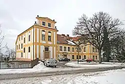 Dolní Přím Castle | |
 Flag 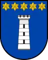 Coat of arms | |
 Dolní Přím Location in the Czech Republic | |
| Coordinates: 50°14′23″N 15°42′31″E / 50.23972°N 15.70861°E | |
| Country | |
| Region | Hradec Králové |
| District | Hradec Králové |
| First mentioned | 1378 |
| Area | |
| • Total | 10.84 km2 (4.19 sq mi) |
| Elevation | 284 m (932 ft) |
| Population (2023-01-01)[1] | |
| • Total | 753 |
| • Density | 69/km2 (180/sq mi) |
| Time zone | UTC+1 (CET) |
| • Summer (DST) | UTC+2 (CEST) |
| Postal code | 503 16 |
| Website | www |
Dolní Přím is a municipality and village in Hradec Králové District in the Hradec Králové Region of the Czech Republic. It has about 800 inhabitants.
Administrative parts
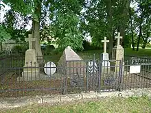
Memorials to the fallen of the battle in 1866
Villages of Horní Přím, Jehlice, Nový Přím and Probluz are administrative parts of Dolní Přím.
History
The first written mention of Dolní Přím is from 1378.[2]
Dolní Přím was partly the site of the Battle of Königgrätz in 1866.
References
- ↑ "Population of Municipalities – 1 January 2023". Czech Statistical Office. 2023-05-23.
- ↑ "Obec Dolní Přím" (in Czech). Obec Dolní Přím. Retrieved 2021-09-28.
External links
Wikimedia Commons has media related to Dolní Přím.
This article is issued from Wikipedia. The text is licensed under Creative Commons - Attribution - Sharealike. Additional terms may apply for the media files.