Sayat | |
|---|---|
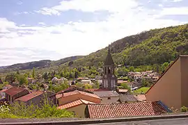 View of Sayat in 2004 | |
.svg.png.webp) Coat of arms | |
Location of Sayat | |
 Sayat  Sayat | |
| Coordinates: 45°49′38″N 3°03′12″E / 45.8272°N 3.0533°E | |
| Country | France |
| Region | Auvergne-Rhône-Alpes |
| Department | Puy-de-Dôme |
| Arrondissement | Riom |
| Canton | Cébazat |
| Intercommunality | CA Riom Limagne et Volcans |
| Government | |
| • Mayor (2020–2026) | Nicolas Weinmeister[1] |
| Area 1 | 8.29 km2 (3.20 sq mi) |
| Population | 2,491 |
| • Density | 300/km2 (780/sq mi) |
| Time zone | UTC+01:00 (CET) |
| • Summer (DST) | UTC+02:00 (CEST) |
| INSEE/Postal code | 63417 /63530 |
| Elevation | 390–818 m (1,280–2,684 ft) (avg. 440 m or 1,440 ft) |
| 1 French Land Register data, which excludes lakes, ponds, glaciers > 1 km2 (0.386 sq mi or 247 acres) and river estuaries. | |
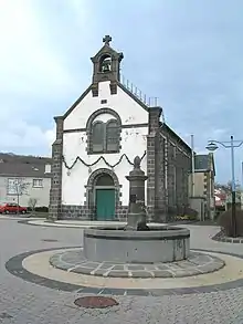
Façade of the village church in Argnat topped by a bell-gable
Sayat (French pronunciation: [saja]) is a commune in the Puy-de-Dôme department in Auvergne in central France.[3]
Geography
Sayat is situated northwest of Clermont-Ferrand. The commune consists of the villages Sayat, Argnat and Le Mas d'Argnat.
Population
| Year | Pop. | ±% p.a. |
|---|---|---|
| 1968 | 1,215 | — |
| 1975 | 1,733 | +5.20% |
| 1982 | 1,996 | +2.04% |
| 1990 | 2,208 | +1.27% |
| 1999 | 2,256 | +0.24% |
| 2007 | 2,270 | +0.08% |
| 2012 | 2,155 | −1.03% |
| 2017 | 2,344 | +1.70% |
| Source: INSEE[4] | ||
See also
References
- ↑ "Répertoire national des élus: les maires". data.gouv.fr, Plateforme ouverte des données publiques françaises (in French). 2 December 2020.
- ↑ "Populations légales 2021". The National Institute of Statistics and Economic Studies. 28 December 2023.
- ↑ INSEE commune file
- ↑ Population en historique depuis 1968, INSEE
External links
Wikimedia Commons has media related to Sayat.
This article is issued from Wikipedia. The text is licensed under Creative Commons - Attribution - Sharealike. Additional terms may apply for the media files.