Combronde | |
|---|---|
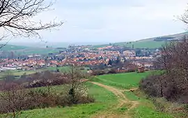 A general view of Combronde | |
.svg.png.webp) Coat of arms | |
Location of Combronde | |
 Combronde  Combronde | |
| Coordinates: 45°58′55″N 3°05′20″E / 45.9819°N 3.0889°E | |
| Country | France |
| Region | Auvergne-Rhône-Alpes |
| Department | Puy-de-Dôme |
| Arrondissement | Riom |
| Canton | Saint-Georges-de-Mons[1] |
| Intercommunality | CC Combrailles Sioule et Morge |
| Government | |
| • Mayor (2020–2026) | Alain Espagnol[2] |
| Area 1 | 18 km2 (7 sq mi) |
| Population | 2,148 |
| • Density | 120/km2 (310/sq mi) |
| Time zone | UTC+01:00 (CET) |
| • Summer (DST) | UTC+02:00 (CEST) |
| INSEE/Postal code | 63116 /63460 |
| Elevation | 356–701 m (1,168–2,300 ft) (avg. 392 m or 1,286 ft) |
| 1 French Land Register data, which excludes lakes, ponds, glaciers > 1 km2 (0.386 sq mi or 247 acres) and river estuaries. | |
Combronde (French pronunciation: [kɔ̃bʁɔ̃d]; Occitan: Combaronda) is a commune in the Puy-de-Dôme department in Auvergne-Rhône-Alpes in central France.
See also
References
- ↑ "Décret 2014-210 du 21 février 2014 portant délimitation des cantons dans le département du Puy-de-Dôme" [2014-210 decree delimiting cantons of Puy-de-Dôme department]. Légifrance (in French). 21 February 2014.
- ↑ "Répertoire national des élus: les maires" (in French). data.gouv.fr, Plateforme ouverte des données publiques françaises. 13 September 2022.
- ↑ "Populations légales 2021". The National Institute of Statistics and Economic Studies. 28 December 2023.
Wikimedia Commons has media related to Combronde.
This article is issued from Wikipedia. The text is licensed under Creative Commons - Attribution - Sharealike. Additional terms may apply for the media files.