Bahçesaray | |
|---|---|
District and municipality | |
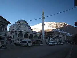
 Central mosque in Bahçesaray | |
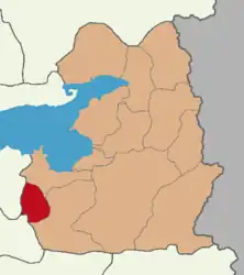
 Map showing Bahçesaray District in Van Province | |
 Bahçesaray Location in Turkey | |
| Coordinates: 38°07′43″N 42°48′27″E / 38.12861°N 42.80750°E | |
| Country | Turkey |
| Province | Van |
| Government | |
| • Mayor | Meki Arvas[1] (AKP) |
| Area | 426 km2 (164 sq mi) |
| Population (2022)[2] | 348,046 |
| • Density | 820/km2 (2,100/sq mi) |
| Time zone | TRT (UTC+3) |
| Postal code | 65710 |
| Area code | 0432 |
| Website | www |
Bahçesaray (Armenian: Մոկս, romanized: Moks, Kurdish: Miks[3]) is municipality and district of Van Province, Turkey.[4] Its area is 426 km2,[5] and its population is 13,495 (2022).[2] It was a bucak in Pervari District of Siirt Province until 1964 and in Gevaş district of Van Province between 1964 and 1987. It is at a distance of 110 kilometres (68 mi) from Van. The town is built on the banks of the Bahçesaray River.[6]
Etymology
The name comes from Persian باغچه سرای "bāghche-sarāy" which means "the Garden Palace". Its former name was Müküs, derived from Armenian Mokkʿ (Armenian: Մոկք) region. In Kurdish: Miks, derived from the Armenian. The word "Mokk'" in classical Armenian language means: "the place of the magic". According to the legend, Amenap'rkich ("Wholly Saviour") abbey that was nearby Moks, has the grave of a magician by name Gaspar. Probably name of "the place of the magic" or just "Mokk" is connected with this mysterious personality. But scientific sources say that in the Urartu era there existed the Moxene tribe and Moxoene, so the names Mokk' and Moks originated from this tribe's name.
The word Bahçesaray is compound of bahçe ("garden") and saray ("palace"). Bakhchysarai in Crimea has the same name.
History
The district corresponds to Historical Armenia's Mok Arandznak district, which was part of the greater province of Moxoene. The district has several ancient Armenian monasteries and churches.[7] The Aparank monastery is located in the vicinity of the town.[8]
In the 19th century Bahçesaray was the center of the Kurdish Emirate of Müküs,[9] until the emirate was defeated by the troops of Ottoman Empire in 1846.[10]
2020 avalanches
On 4 and 5 February 2020, a pair of avalanches struck a highway in the district, leaving at least 41 people dead and 84 others injured.[11]
Composition
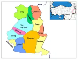
There are 20 neighbourhoods in Bahçesaray District:[12]
- Akyayla
- Altındere
- Altıntaş
- Arvas
- Bağcılar
- Çatbayır
- Cevizlibelen
- Çiçekli
- Çömlekçi
- Elmayaka
- Fekiye Teyran
- Güneyyamaç
- İslam
- Kaşıkçılar
- Paşaköy
- Şişli
- Ulubeyli
- Ünlüce
- Yaşlıkavak
- Yaylakonak
References
- ↑ "BELEDİYE BAŞKANI MEKİ ARVAS GÖREVİNE BAŞLADI" (in Turkish). Archived from the original on 28 January 2020. Retrieved 19 February 2020.
- 1 2 "Address-based population registration system (ADNKS) results dated 31 December 2022, Favorite Reports" (XLS). TÜİK. Retrieved 19 September 2023.
- ↑ Adem Avcıkıran (2009). Kürtçe Anamnez Anamneza bi Kurmancî (PDF) (in Turkish and Kurdish). p. 57. Archived (PDF) from the original on 27 January 2020. Retrieved 17 December 2019.
- ↑ Büyükşehir İlçe Belediyesi, Turkey Civil Administration Departments Inventory. Retrieved 19 September 2023.
- ↑ "İl ve İlçe Yüz ölçümleri". General Directorate of Mapping. Retrieved 19 September 2023.
- ↑ Sinclair, T. A. (1987). Eastern Turkey: An Architectural & Archaeological Survey, Volume I. Pindar Press. p. 234. ISBN 0907132324.
- ↑ Sinclair, T. A. (1987), pp. 234–237
- ↑ Sinclair, T. A. (1987), pp. 238–239
- ↑ Aydın, Suavi; Verheij, Jelle (2012). Jorngerden, Joost; Verheij, Jelle (eds.). Social Relations in Ottoman Diyarbekir, 1870-1915. Brill. p. 27. ISBN 9789004225183.
- ↑ Aydın, Suavi; Verheij, Jelle (2012). Jorngerden, Joost; Verheij, Jelle (eds.). Social Relations in Ottoman Diyarbekir, 1870-1915. Brill. p. 38. ISBN 9789004225183.
- ↑ "Avalanche in Turkey wipes out rescue team; 38 dead overall". Associated Press. 5 February 2020. Archived from the original on 5 February 2020. Retrieved 5 February 2020.
- ↑ Mahalle, Turkey Civil Administration Departments Inventory. Retrieved 19 September 2023.

.svg.png.webp)