Berzosa del Lozoya | |
|---|---|
 Flag  Coat of arms | |
_mapa.svg.png.webp) | |
 Berzosa del Lozoya Location in Spain | |
| Coordinates: 40°58′31″N 3°31′28″W / 40.97528°N 3.52444°W | |
| Country | |
| Autonomous community | |
| Province | |
| Area | |
| • Total | 14.3 km2 (5.5 sq mi) |
| Elevation | 1,094 m (3,589 ft) |
| Population (2018)[1] | |
| • Total | 198 |
| • Density | 14/km2 (36/sq mi) |
| Time zone | UTC+1 (CET) |
| • Summer (DST) | UTC+2 (CEST) |
| Postal code | 28194 |
Berzosa de Lozoya (Spanish pronunciation: [beɾˈθosa ðe loˈθoʝa]) is a municipality situated in the north of the autonomous community of Madrid in central Spain.[2] It had 234 inhabitants in 2011, covers an area of 14.3 km² and a population density of 16.36people per km².
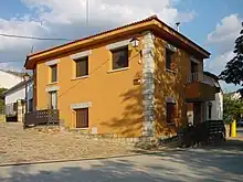
City Hall
Education
There is one nursery (public) in Berzosa del Lozoya.
References
- ↑ Municipal Register of Spain 2018. National Statistics Institute.
- ↑ Los 'nuevos vecinos' de Berzosa, el único consuelo, El País, 16 March 2004
External links
Wikimedia Commons has media related to Berzosa del Lozoya.
- Statistics institute of the Comunidad de Madrid > Ficha municipal Archived 2016-03-03 at the Wayback Machine
This article is issued from Wikipedia. The text is licensed under Creative Commons - Attribution - Sharealike. Additional terms may apply for the media files.