Paracuellos del Jarama | |
|---|---|
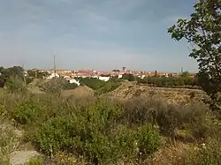 View of Paracuellos from the South | |
 Flag  Seal | |
 Paracuellos del Jarama Location in Spain | |
| Coordinates: 40°30′17″N 3°31′48″W / 40.50472°N 3.53000°W | |
| Country | |
| Autonomous community | Community of Madrid |
| Comarca | Madrid metropolitan area |
| Government | |
| • Mayor | Mesa |
| Area | |
| • Total | 16.96 sq mi (43.92 km2) |
| Elevation | 2,152 ft (656 m) |
| Population (2018)[1] | |
| • Total | 24,521 |
| • Density | 1,400/sq mi (560/km2) |
| Time zone | UTC+1 (CET) |
| • Summer (DST) | UTC+2 (CEST) |
| Website | Official website |
Paracuellos del Jarama is a small town and municipality in the Community of Madrid, Spain. It is located northeast from Madrid and very close to Madrid-Barajas Airport. The etymology of the name is unclear.[2]
In 1936, it (along with Torrejón de Ardoz) was the site of the Paracuellos massacres.
Transport
Urban lines
- Line 1: Altos de Jarama urbanization - Miramadrid
- Line 2: Picón del cura - Los Berrocales urbanization
- Line 3: Industrial estate - C.C. San Fernando
Interurban lines
- 210: San Sebastián de los Reyes (Infanta Sofía Hospital) - Paracuellos del Jarama
- 211: Madrid (Canillejas) - Paracuellos del Jarama
- 212: Madrid (Canillejas) - Paracuellos del Jarama (Miramadrid)
- 213: Madrid (Canillejas) - Belvis
- 215: Torrejón de Ardoz - Paracuellos del Jarama
- 256: Madrid (Canillejas) - Daganzo de Arriba - Valdeavero
- 263: Madrid (Barajas) - Cobeña - Algete
References
- ↑ Municipal Register of Spain 2018. National Statistics Institute.
- ↑ Javier Nájera Martínez, Luis Yuste Ricote: Nombre: Paracuellos, Apellido: de Jarama (Spanish), 3 October 2016, retrieved 10 January 2020.
This article is issued from Wikipedia. The text is licensed under Creative Commons - Attribution - Sharealike. Additional terms may apply for the media files.