Blewford, Arkansas | |
|---|---|
Ghost Town | |
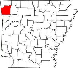
 Blewford, Arkansas Blewford' historical position in Arkansas. | |
| Coordinates: 36°10′8″N 94°19′53″W / 36.16889°N 94.33139°W | |
| Country | |
| State | |
| County | Washington |
| Township | Harmon |
| Elevation | 365 m (1,198 ft) |
| Time zone | UTC-6 (Central (CST)) |
| • Summer (DST) | UTC-5 (CDT) |
| ZIP code | 72704 |
| Area code | 479 |
| GNIS feature ID | 65290[1] |
Blewford was a community in Harmon Township, Washington County, Arkansas, United States.[1] It is located within the Ozark National Forest approximately one quarter mile east of Litteral Road and the Benton County line. US Route 412 is approximately one mile to the north.[2]
A post office existed from approximately 1899 to 1902.
References
This article is issued from Wikipedia. The text is licensed under Creative Commons - Attribution - Sharealike. Additional terms may apply for the media files.