Onda, Arkansas | |
|---|---|
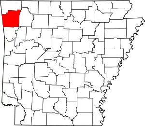
 Onda, Arkansas Onda's position in Arkansas | |
| Coordinates: 35°51′59.3″N 94°17′30.8″W / 35.866472°N 94.291889°W | |
| Country | |
| State | |
| County | Washington |
| Township | Valley |
| Elevation | 514 m (1,686 ft) |
| Time zone | UTC-6 (Central (CST)) |
| • Summer (DST) | UTC-5 (CDT) |
| ZIP code | 72774 |
| Area code | 479 |
| GNIS feature ID | 72952 |
| U.S. Geological Survey Geographic Names Information System: Onda, Arkansas | |
Onda is an unincorporated community in Valley Township, Washington County, Arkansas, United States.[1] It is located on County Route 29 (Malico Mountain Road) south of Prairie Grove.[2]
References
- 1 2 "Onda, Arkansas". Geographic Names Information System. United States Geological Survey. Retrieved January 20, 2012.
- ↑ Arkansas Atlas and Gazetteer (Map) (Second ed.). DeLorme. § 22.
This article is issued from Wikipedia. The text is licensed under Creative Commons - Attribution - Sharealike. Additional terms may apply for the media files.