| Scottish Gaelic name | Cola |
|---|---|
| Pronunciation | [ˈkʰɔl̪ˠə] ⓘ |
| Scots name | Coll[1] |
| Meaning of name | Pre-Celtic and unclear |
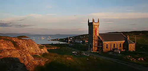
 View of Arinagour | |
| Location | |
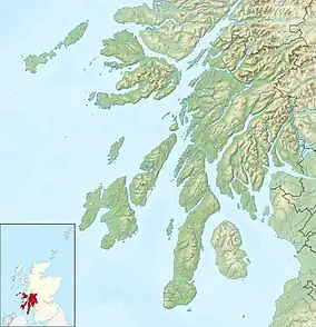
 Coll Coll shown within Argyll and Bute | |
| OS grid reference | NM207584 |
| Coordinates | 56°38′N 6°33′W / 56.64°N 6.55°W |
| Physical geography | |
| Island group | Mull |
| Area | 7,685 ha (29+5⁄8 sq mi)[2] |
| Area rank | 18 [3] |
| Highest elevation | Ben Hogh 106 m (348 ft)[2] |
| Administration | |
| Sovereign state | United Kingdom |
| Country | Scotland |
| Council area | Argyll and Bute |
| Demographics | |
| Population | 195[4] |
| Population rank | 32 [3] |
| Population density | 2.5/km2 (6.5/sq mi)[2][4] |
| Largest settlement | Arinagour[2] |
| References | [2][5] |
| Designated | 31 March 1995 |
| Reference no. | 723[6] |
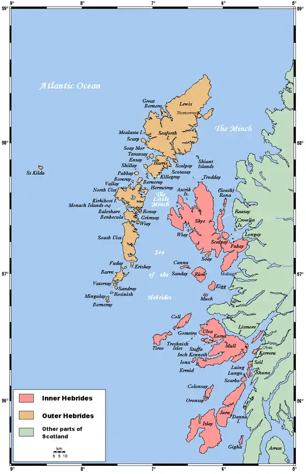
Coll (/ˈkɒl/; Scottish Gaelic: Cola; Scots: Coll)[7] is an island located west of the Isle of Mull in the Inner Hebrides of Scotland. Coll is known for its sandy beaches, which rise to form large sand dunes, for its corncrakes, and for Breacachadh Castle. It is in the council area of Argyll and Bute.
Geology
Coll is formed largely from gneiss forming the Lewisian complex, a suite of metamorphic rocks of Archaean to early Proterozoic age.[8] The eastern part of the island is traversed by numerous normal faults most of which run broadly northwest-southeast. Dolerite and camptonite dykes of Permo-Carboniferous or Tertiary age are also seen in the east of the island. Quaternary sediments include raised beach deposits which are frequent around Coll’s coastline whilst stretches of alluvium occupy some low inland areas. There are considerable areas of blown sand in the west and along stretches of the north coast and of peat southwest from Arinagour.[9]
Geography
Coll is about 13 miles (21 kilometres) long by 3 miles (5 kilometres) wide and has a population of around 150. Coll's sandy beaches rise to form large sand dunes. The highest point on Coll is Ben Hogh in the mid-west of the island, which is a ridge with two tops running northwest to southeast. It rises initially to a height of 104 metres (341 feet), with a triangulation pillar, and to 106 m (348 ft) 450 m (490 yd) to the southeast.[5]
Settlements
Arinagour (Scottish Gaelic: Àirigh nan Gobhar),[10] is the main settlement on the island located at the head of Loch Eatharna, on the east coast.[11] Other inhabited locations include:
- Acha (Scottish Gaelic: An t-Achadh),[12] a crofting settlement located 5 km (3 mi) south-west of Arinagour.[13]
- Arileod (Scottish Gaelic: Àirigh Leòid),[10] located on the west coast; 7 km (4+1⁄2 mi) south-west of Arinagour.[14]
- Arnabost (Scottish Gaelic: Àrnabost),[10] located 3 km (2 mi) north-west of Arinagour. it is the junction for travel between Sorisdale, Clabhach and Arinagour.[15]
- Ballyhaugh (Scottish Gaelic: Baile Hogh),[16] located on the northern part of Hough Bay; 5 km (3 mi) west of Arinagour.[17]
- Bousd (Scottish Gaelic: Babhsta),[18] located 7 km (4+1⁄2 mi) north-east of Arinagour.[19]
- Clabhach (Scottish Gaelic: A' Chlabaich),[20] located on the north-west coast; 5 km (3 mi) north-west of Arinagour.[21]
- Cornaigmore
- Crossapol (Scottish Gaelic: Crosabol),[22] located on the south-west coast.[23]
- Grishipoll
- Sorisdale
- Totronald (Scottish Gaelic: Tobhta Raghnaill), located on the west coast 7 km (4+1⁄2 mi) southwest of Arinagour.[24]
- Uig (Scottish Gaelic: Ùig),[25] located 1 km (1⁄2 mi) north-east of the head of Loch Breachacha.[26]
Etymology
Coll is sometimes derived from Gaelic coll, 'hazel'.[27] However, the name is given as Colosus in the Life of St Columba by Adamnán, the seventh century abbot of Iona.[28] As /s/ between vowels had been lost in Celtic before Adamnán's time, Watson suggests that Colosus may represent a pre-Celtic name.[27] Richard Coates has proposed that the name may be related to Greek kolossós and may have referred to a humanoid standing stone located on the island, like those still seen on North Uist and Lewis.[29] As Kolossós is not originally a Greek word,[29] Coates suggests that the name could have been given to Coll at a time when the kolossói of Mediterranean culture were well-known, or named "by speakers of a language in which the ancestor of the word was the native term."[30] In Icelandic, the word kollur (Old Norse: kollr, Norwegian: koll or kolle) means "a rounded protrusion, such as a rounded mountaintop, or a tussock".
History
Early history
.jpg.webp)
In the 6th century, an Irish invasion led to the establishment of the Gaelic kingdom of Dál Riata, which included Coll. Dál Riata was divided into four kin-groups, of which the Cenél Loairn ruled Coll, Mull, and the adjacent mainland, which together consequently became known as Lorn, after them. Coll shared the history of Lorn for the next 1000 years, becoming part of the Kingdom of the Isles under Norwegian dominion, then the MacDougall subdivision of that kingdom after Somerled.
Coll, like other Hebridean islands, has several crannógs (artificial islands) located in some of its lochs, dating from this early period. It is difficult to estimate the exact age of these islands, but several are thought to date to the Norse period; local traditions describe three - Dùn Anlaimh, Dùn an Achaidh, Dùn Dubh - as having been Norse strongholds which survived until they were attacked by the Macleans.
The 1266 Treaty of Perth transferred the Norwegian crown dependency to the Scottish king[note 1]. Following the MacDougall defeat in the dispute between king John Balliol and Robert de Bruys (they had backed the former), the position of sheriff of Argyll was created to have shrieval authority over Lorn[note 2], and the MacDougall lands were merged into the Lordship of the Isles. Though MacDougall authority was restored in 1357, by king David II, the MacDougall heir had 3 years previously[note 3], quitclaimed any rights to Mull (including Coll), which therefore remained with the Lord of the Isles.
MacLeans of Coll

'Altera Merces' translates to "Either shall be my reward" (victory or death)
.jpg.webp)
Foundations
The heirs of the Cenél Loairn were now the MacLeans, who still resided in Lorn, as vassals of the Lord of the Isles. However, the daughter of the first Lord of the Isles, John of Islay, married the leader of the MacLeans, Lachlan Lubanach[note 4]; subsequent MacLean leaders thus descended from John of Islay. Lachlan's grandson, Lachlan Bronneach[note 5] had four sons, the eldest of which (Donald) was a bastard and would thus not inherit the MacLean leadership.

Donald took an armed band to Ardtornish Castle, home of the Lord of the Isles, and demanded that the third Lord of the Isles (Alexander) give him an inheritance, by granting him a share of the lands inherited from John of Islay (on the basis that Donald's grandfather [note 6] was Alexander's 1st cousin); Alexander conceded, granting Donald Ardgour and other lands. Having observed this, the youngest son of Lachlan Bronneach - John Garbh[note 7] - decided to try the same behaviour, and as a result was made laird of Coll, and other lands, by Alexander. King James II confirmed Alexander's grants to John.
John Garbh's heirs became known as the MacLeans of Coll, and constructed Breachacha Castle, on the south coast of Coll, as their base. John Garbh's son John Abraich was killed at the Battle of Corpach defending his Lochaber lands against Clan Cameron. Following his death, all succeeding McLean's of Coll would bear the title 'Mac Iain Abraich' , meaning 'Son of Lochaber John' pronounced and anglicised to 'McEnabrey'. Coll remained home to this branch of the Clan Maclean for 500 years. In 1549 Dean Monro wrote of Coll that it was:
- "ane mane fertile Ile inhabite and manurit, with an castell and ane paroch kirk in it, gude for fishing and fowlers, with ane utter fine Falcons nest in it".[31]
He wrote of Rum:
- "It pertains to McKenabrey of Coll".[31]
The illustration at right by McIan of 1845, represents Hector McLean 14th Laird of Coll (c. 1720's) with the infamous 'yellow stick' used to convert the islanders of Rum and Coll from Catholicism. He drove recalcitrant natives to church by a smart application of his walking stick; those who yielded were thus said to come under Creideamh a’ bhata-bhuidhe.
Feud with the MacLeans of Duart

At the end of the 15th century, the Lordship of the Isles was dismantled, which made the MacLeans of Coll direct vassals of the crown, which caused conflict with the heirs of the eldest lawful son of Lachlan Bronneach[note 8] - the Macleans of Duart. The leader of the latter claimed to be leader of all Macleans, as Lachlan Bronneach and his forefathers had been, but the Macleans of Coll argued that their only feudal superior was the king, and they were therefore independent of the Duart branch of the family; essentially the dispute was between feudalism and traditional family leadership principles.
Simmering tensions eventually exploded in 1561, when the MacLeans of Duart invaded the lands of the MacLeans of Coll. The leader of the latter opted to appeal to the Privy Council for assistance; the privy council agreed with the MacLeans of Coll, ordering the MacLeans of Duart to pay reparations. However, in 1583, a decade after succeeding to his position, the new leader of the MacLeans of Duart re-invaded Coll with the intention of taking the island for themselves. A battle was fought at Totronald near Breacachadh Castle where the Coll clan overwhelmed the Duarts, chopped off their heads and threw them in the stream, which is still known as "the stream of the heads".
Feud with the Earl of Argyll

In the late 17th century, the MacLeans of Duart were in debt to the Earl of Argyll; these stemmed from the civil war when the MacLeans had supported the royalists against the covenanters. Ironically, though himself a royalist, the Earl's father had been one of the most senior covenanters; many therefore felt that the debt was unjust, and in 1676, the MacLeans appealed to the Privy Council, but no decision was reached.
The MacLeans of Coll subsequently supported those of Duart in small guerilla actions against the Earl's lands. Unlike the MacLeans, the Earl was a supporter of the Scottish Reformation, and in 1679 managed to obtain Fire and Sword powers against popery in the Highlands. He launched an attack on Coll, in revenge for the support given to the MacLeans of Duart; Breachacha Castle surrendered on 2 July 1679. However, in 1681, after equivocating over his obedience to king James VII (a Roman Catholic), the Earl was arrested for treason, and Coll was returned to the MacLeans (of Coll).
Departure

_(14598330869).jpg.webp)
In the late 18th century there were about 1,000 people supported by agriculture and fishing.[2] However, the collapse in the kelp market after the end of the Napoleonic Wars, followed by the Highland Potato Famine, caused a great deal of hardship on the island. By the mid 19th century, half the population had chosen to leave, many of them moving to Australia, Canada, or South Africa.
The obituary of Alexander McLean, 16th of Coll (Alasdair Ruadh):
DIED-On the 10th of April last, at Coll House, in the Island of Mull, Alexander M'LEAN, Esq., Laird of Coll, in the 84th year of his age—the venerable Parent of the Lady of Major M'Leod. The respect in which the deceased was held by his numerous tennants (sic) and friends, was truly indicated upon the melancholy occasion of his Funeral. The steam boat that conveyed the respected remains from the scene of death to the vault in the family Chapel of Coll, was crowded with anxious mutitudes (sic), eager to evince by their attendance the last sad offics that can be paid to decayed mortality. Every countenance bore the impression of deep,— unfeigned sorrow, which, although tending the more firmly to impress on the minds of the surviving relatives — the extent of their irreparable loss — convinced them, that the deceased's worth was imprinted indelibly upon their hearts. The deceased went with honour to the grave. He lived in the hearts of all who had the pleasure of his acquaintance, and was justly esteemed the "Father of his People." He was the best of husbands — the most affectionate of fathers — an indulgent master — a liberal landlord— and as he lived a sincere Christian, so he died in the firm hope of his enjoying hereafter the rich rewards of a well spent life. The Deceased Laird is succeeded by his only surviving son, HUGH.
— The Cornwall Chronicle[32]
In 1848, the heir of the Macleans of Coll himself, Alexander Maclean, emigrated to Natal, in South Africa (where he later died, unmarried). In 1856, Alexander's father, Hugh MacLean, decided to sell Coll.
Present day
In the 2011 census, the island's population was recorded as 195, representing an increase over the previous decade of nearly 19%[4][33] During the same period Scottish island populations as a whole grew by 4% (to 103,702).[34]
Transport

There are only two main roads on Coll. The main hub of the island is the island's largest settlement, Arinagour. Just over a kilometre (0.7 miles) south of Arinagour is the Caledonian MacBrayne ferry terminal.[35] The ferry travels from Oban to Coll to Tiree; and a return trip from Tiree, to Coll, to Oban.[36][37] The ferry between Oban and Castlebay on Barra goes via Coll and Tiree once a week.
The airport on the island, (IATA: COL) is located between Uig and Arileod. Highland Airways who originally operated the route to Oban went into administration in 2010,[38] but a new operator, Hebridean Air Services now operates the route under a PSO with flights to Oban, Tiree and Colonsay. The aircraft used for the flights are a BN2 Islander (G-HEBS). Hebridean headquarters are at Cumbernauld Airport, North Lanarkshire.
| Preceding station | Ferry | Following station | ||
|---|---|---|---|---|
| Tiree | Caledonian MacBrayne Ferry |
Oban |
Economy

In July 2012, Princess Anne formally opened the Isle of Coll's new community centre, An Cridhe, and hostel, Coll Bunkhouse. Owned and managed by the community-led organisation Development Coll, the new facilities were built to provide much needed amenities on the island and a social hub for the local community. An Cridhe now hosts a series of annual events such as a half marathon, the Coll Show, a basking shark festival, a bird festival and a chamber music festival, as well as a range of music, comedy, theatre and dance throughout the year.
In December 2013 Coll secured 'dark skies' status, the second location in Scotland.[39] The island has no street lights and little other light pollution, allowing unobstructed views of the night sky on clear nights. In winter the Northern Lights are often visible.[40]
The charity Project Trust, which organises overseas volunteering and gap-years, has been based on the island since 1974.[41][42] The founder, Nicholas Maclean-Bristol, also restored Breacachadh Castle.[43]
Wildlife


There is an extensive RSPB reserve towards the west end of the island.[44] One of the main attractions is the rare corncrake. Traditional local farming practices have helped this once common British bird to survive.
There is also a small population of sand lizards, as much of 39 individuals were introduced by scientists to test whether they can survive so far north in the 1970s and are still thriving today.
In 2010, a colony of short-necked oil beetles was found on the island. The beetle, thought to be extinct in the UK, is now known only to occur in southern England and Coll. It is parasitic on ground-dwelling bees, and is also flightless, raising the question of how it arrived on the island. It does not appear to be found on neighbouring Tiree, possibly because of a difference in terrain. Modern farming methods had partly caused its demise elsewhere.[45]
In fiction


Mairi Hedderwick, the illustrator and author, used to live on Coll and has used the island as the setting for her Katie Morag series of children's books. In the books, Coll is known by the fictional name of the Isle of Struay.[46]
In Alexander McCall Smith's The Charming Quirks of Others the protagonist, Isabelle Dalhousie, discusses Coll as a place for a honeymoon.[47]
See also
Notes
- ↑ rather than Scotland; they remained a crown dependency, like the Isle of Man (which had itself once been part of the Kingdom of the Isles)
- ↑ Over Lorn only. Authority was only extended to the rest of the region now known as Argyll by a gradual process over the following centuries. Kintyre, for example, was dealt with by the sheriff of Tarbert for many centuries after this.
- ↑ 1354
- ↑ Cunning
- ↑ fat-bellied
- ↑ Red Hector, of the Battles
- ↑ Rough
- ↑ Lachlan Og
References
- ↑ "Map of Scotland in Scots - Guide and gazetteer" (PDF).
- 1 2 3 4 5 6 Haswell-Smith (2004) p. 118-122
- 1 2 Area and population ranks: there are c. 300 islands over 20 ha in extent and 93 permanently inhabited islands were listed in the 2011 census.
- 1 2 3 National Records of Scotland (15 August 2013). "Appendix 2: Population and households on Scotland's Inhabited Islands" (PDF). Statistical Bulletin: 2011 Census: First Results on Population and Household Estimates for Scotland Release 1C (Part Two) (PDF) (Report). SG/2013/126. Retrieved 14 August 2020.
- 1 2 Ordnance Survey. OS Maps Online (Map). 1:25,000. Leisure.
- ↑ "Coll". Ramsar Sites Information Service. Retrieved 25 April 2018.
- ↑ Mac an Tàilleir (2003) p. 31
- ↑ "Tiree and Coll, Scotland sheet 42 and 51W (Solid and Drift)". BGS large map images. British Geological Survey. Retrieved 3 February 2020.
- ↑ "Onshore Geoindex". British Geological Survey. British Geological Survey. Retrieved 3 February 2020.
- 1 2 3 Mac an Tàilleir (2003) p. 8
- ↑ "Arinagour". Gazetteer for Scotland. Retrieved 13 December 2009.
- ↑ Mac an Tàilleir (2003) p. 1
- ↑ "Acha". Gazetteer for Scotland. Retrieved 13 December 2009.
- ↑ "Arileod". Gazetteer for Scotland. Retrieved 13 December 2009.
- ↑ "Arnabost". Gazetteer for Scotland. Retrieved 13 December 2009.
- ↑ Mac an Tàilleir (2003) p. 14
- ↑ "Ballyhaugh". Gazetteer for Scotland. Retrieved 13 December 2009.
- ↑ Mac an Tàilleir (2003) p. 21
- ↑ "Bousd". Gazetteer for Scotland. Retrieved 13 December 2009.
- ↑ Mac an Tàilleir (2003) p. 29
- ↑ "Clabhach". Gazetteer for Scotland. Retrieved 13 December 2009.
- ↑ Mac an Tàilleir (2003) p. 34
- ↑ "Totronald". Gazetteer for Scotland. Retrieved 13 December 2009.
- ↑ "Totronald". Gazetteer for Scotland. Retrieved 13 December 2009.
- ↑ Mac an Tàilleir (2003) p. 116
- ↑ "Uig". Gazetteer for Scotland. Retrieved 13 December 2009.
- 1 2 Broderick, George (2013). "Some Island Names in the Former 'Kingdom of the Isles': a reappraisal" (PDF). The Journal of Scottish Name Studies: 12. Archived from the original (PDF) on 8 April 2015.
- ↑ Coates, Richard (2009). "A Glimpse through a Dirty Window into an Unlit House: Names of Some North-West European Islands" (PDF). In Ahrens, Wolfgang; Embleton, Sheila; Lapierre, André (eds.). Names in Multi-Lingual, Multi-Cultural and Multi-Ethnic Contact: Proceedings of the 23rd International Congress of Onomastic Sciences: August 17‒22, York University, Toronto, Canada. Toronto: York University. p. 236. ISBN 978-1-55014-521-2. Archived from the original (PDF) on 7 April 2015.* Early forms are listed in Broderick, George (2013). "Some Island Names in the Former 'Kingdom of the Isles': a reappraisal" (PDF). The Journal of Scottish Name Studies: 12. Archived from the original (PDF) on 8 April 2015.
- 1 2 Coates, Richard (2009). "A Glimpse through a Dirty Window into an Unlit House: Names of Some North-West European Islands" (PDF). In Ahrens, Wolfgang; Embleton, Sheila; Lapierre, André (eds.). Names in Multi-Lingual, Multi-Cultural and Multi-Ethnic Contact: Proceedings of the 23rd International Congress of Onomastic Sciences: August 17‒22, York University, Toronto, Canada. Toronto: York University. p. 236. ISBN 978-1-55014-521-2. Archived from the original on 8 April 2015. Retrieved 8 April 2015.
{{cite book}}: CS1 maint: bot: original URL status unknown (link) - ↑ Coates, Richard (2009). "A Glimpse through a Dirty Window into an Unlit House: Names of Some North-West European Islands" (PDF). In Ahrens, Wolfgang; Embleton, Sheila; Lapierre, André (eds.). Names in Multi-Lingual, Multi-Cultural and Multi-Ethnic Contact: Proceedings of the 23rd International Congress of Onomastic Sciences: August 17‒22, York University, Toronto, Canada. Toronto: York University. p. 237. ISBN 978-1-55014-521-2. Archived from the original (PDF) on 7 April 2015.
- 1 2 Munro (1961) p. 66
- ↑ Obituary of Alexander McLean 16th of Coll (Alasdair Ruadh). The Cornwall Chronicle (Launceston, Tasmania) 1835-09-12.
- ↑ General Register Office for Scotland (28 November 2003) Scotland's Census 2001 – Occasional Paper No 10: Statistics for Inhabited Islands. Retrieved 26 February 2012.
- ↑ "Scotland's 2011 census: Island living on the rise". BBC News. Retrieved 18 August 2013.
- ↑ "Isle of Coll Tourist Guide Inner Hebrides Scottish Islands". www.iknow-scotland.co.uk. Retrieved 13 December 2009.
- ↑ "Coll: Getting there/around". Caledonian MacBrayne. Archived from the original on 6 May 2009. Retrieved 13 December 2009.
- ↑ "Coll and Tiree timetable (25 October 2009 to 25 March 2010)". Caledonian MaBrayne. Archived from the original (gif) on 3 November 2007. Retrieved 13 December 2009.
- ↑ "Highland Airways goes into administration". BBC News Online. 25 March 2010. Retrieved 25 March 2010.
- ↑ "Isle of Coll secures 'dark isle' status". BBC News. 9 December 2013. Retrieved 9 December 2013.
- ↑ Thomson, Andrew (30 April 2012). "BBC News - Residents of Coll in bid for first 'dark isle' status". BBC News. bbc.co.uk. Retrieved 30 April 2012.
- ↑ Kerr, Moira (17 March 2008) "Charity plays vital role in survival of remote island". Aberdeen. Press and Journal.
- ↑ "About Project Trust" Archived 14 April 2011 at the Wayback Machine Project Trust. Retrieved 5 April 2008.
- ↑ "Coll". Gazetteer for Scotland. Retrieved 13 December 2009.
- ↑ "Guide to Coll". RSBP. Retrieved 6 January 2008.
- ↑ Ross, John (16 July 2010) "Beetle mania as 'extinct' insect found on Scots isle". The Scotsman. Retrieved 19 July 2010.
- ↑ "Random House - Mairi Hedderwick". Retrieved 6 January 2008.
- ↑ Smith, Alexander McCall (2010). The Charming Quirks of Others. New York: Anchor Books. p. 98. ISBN 9780307379177.
Bibliography
- Haswell-Smith, Hamish (2004). The Scottish Islands. Edinburgh: Canongate. ISBN 978-1-84195-454-7.
- Mac an Tàilleir, Iain (2003) Ainmean-àite/Placenames. (pdf) Pàrlamaid na h-Alba. Retrieved 26 August 2012.
- Munro, R. W. (1961)Electronic Monro's Western Isles of Scotland and Genealogies of the Clans. Edinburgh and London. Oliver and Boyd.
- Watson, W. J. (1994) The Celtic Place-Names of Scotland. Edinburgh; Birlinn. ISBN 1841583235. First published 1926.

