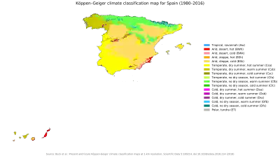
The climate in Spain varies considerably across the country's various regions.[1][2] The country is dominated by five major climate regions, with other regions including smaller portions of the country. Spain is vulnerable to climate change; its Mediterranean environment and location in Europe mean that it will experience greater heatwaves and dry weather with increasing warming.
Zones
Five main climatic zones can be distinguished, according to the country's Köppen-Geiger climate classification and orographic conditions:[3][4][5]
- The hot-summer Mediterranean climate (Csa) which is also characterized by dry and warm/hot summers and cool to mild and wet winters. According to the Köppen climate classification, this climate is dominant on the Iberian Peninsula, particularly the variety with summer droughts, covering all but the far northern part of the country where the Oceanic climate predominates. The hot-summer Mediterranean climate is further divided into the "Standard Mediterranean" of lowland regions and continental Mediterranean climate of the interior, according to altitude and the mildness or harshness of the winter season. The Standard Mediterranean covers coastal areas (excluding the northern Atlantic coast) the Guadalquivir river basin and the lower reaches of the Tagus and Guadiana basins to the west of the country. The continental Mediterranean climate predominates in Spain's vast table lands, Meseta Central, of the interior.
- The warm-summer Mediterranean climate (Csb) which predominates in parts of northwestern Spain and mostly inland in central-northern Spain at altitudes above 900-1000 masl.
- The oceanic climate (Cfb) is located in the northern part of the country, especially in the regions of Galicia, Basque Country, Asturias, Cantabria, and Navarre. This region has regular snowfall in the winter months.
- The semiarid climate (BSh and BSk) is predominant in the south eastern part of the country (Almeria province in Eastern Andalusia, Murcia region and Alicante province in Southern Valencia) and in the middle reaches of the Ebro valley to the north east (Zaragoza province), reaching as far west as southern Navarre. It is also present in large areas of the central table lands (primarily in Madrid and in the La Mancha region which includes parts of Cuenca, Guadalajara, and Toledo provinces) and some of the driest areas of Extremadura. In contrast to the Mediterranean climate, the dry season continues beyond the end of summer and the vegetation is less dense.
- The warm-summer continental climate (Dfb) which can be found in many areas in north-eastern Spain, in areas starting with altitudes above 1000-1100 masl. It can be found also in some areas in the Cantabrian Mountains and the highest areas of the Sistema Ibérico mountain range in central-eastern Spain.
Apart from the five main climate zones, other noticeable sub-zones can be found, such as the humid subtropical climate in large areas in the northern half of Catalonia going down to Barcelona, the province of Huesca and northern Navarre. The dry continental climates all across Spain in the highest areas (notably in the Sierra Nevada and the highest areas in central-northern Spain), the alpine climate and the Subarctic climate in the higher areas of northern Spain's various mountain ranges (notably the Cantabrian Mountains and the Pyrenees), a tropical climate in the coastal areas of the Canary Islands and a hot desert climate in the Southeastern coastline and eastern parts of the Canary Islands, notably around Almeria and Las Palmas.[1]
Hot summer Mediterranean climate
The hot-summer Mediterranean climate Csa is found in many parts of Spain's Mediterranean coast, from the border with Portugal to the middle of the province of Granada. Then it starts in Calpe (with some exceptions such as the city of Valencia), and goes to the border with France. It also extends inland in Andalusia and Extremadura. It is characterized by hot, dry summers and mild winters with infrequent frosts.[6] The summers are hot, the winters are mild and most of precipitation falls in the autumn. Examples of cities with Csa climate are Málaga, Barcelona, Palma or Seville.
| Climate data for Málaga Airport (AGP), Churriana (1981–2010), Extremes (1942-present) | |||||||||||||
|---|---|---|---|---|---|---|---|---|---|---|---|---|---|
| Month | Jan | Feb | Mar | Apr | May | Jun | Jul | Aug | Sep | Oct | Nov | Dec | Year |
| Record high °C (°F) | 26.8 (80.2) |
30.0 (86.0) |
31.4 (88.5) |
33.0 (91.4) |
35.0 (95.0) |
41.0 (105.8) |
44.2 (111.6) |
44.0 (111.2) |
40.0 (104.0) |
36.3 (97.3) |
30.4 (86.7) |
29.9 (85.8) |
44.2 (111.6) |
| Mean daily maximum °C (°F) | 16.8 (62.2) |
17.7 (63.9) |
19.6 (67.3) |
21.4 (70.5) |
24.3 (75.7) |
28.1 (82.6) |
30.5 (86.9) |
30.8 (87.4) |
28.2 (82.8) |
24.1 (75.4) |
20.1 (68.2) |
17.5 (63.5) |
23.3 (73.9) |
| Daily mean °C (°F) | 12.1 (53.8) |
12.9 (55.2) |
14.7 (58.5) |
16.3 (61.3) |
19.3 (66.7) |
23.0 (73.4) |
25.5 (77.9) |
26.0 (78.8) |
23.5 (74.3) |
19.5 (67.1) |
15.7 (60.3) |
13.2 (55.8) |
18.5 (65.3) |
| Mean daily minimum °C (°F) | 7.4 (45.3) |
8.2 (46.8) |
9.8 (49.6) |
11.1 (52.0) |
14.2 (57.6) |
18.0 (64.4) |
20.5 (68.9) |
21.1 (70.0) |
18.8 (65.8) |
15.0 (59.0) |
11.3 (52.3) |
8.9 (48.0) |
13.7 (56.7) |
| Record low °C (°F) | −2.6 (27.3) |
−3.8 (25.2) |
−1.2 (29.8) |
2.8 (37.0) |
5.0 (41.0) |
12.8 (55.0) |
14.0 (57.2) |
15.2 (59.4) |
10.2 (50.4) |
5.6 (42.1) |
1.4 (34.5) |
−0.8 (30.6) |
−3.8 (25.2) |
| Average precipitation mm (inches) | 69 (2.7) |
60 (2.4) |
52 (2.0) |
44 (1.7) |
20 (0.8) |
6 (0.2) |
0 (0) |
6 (0.2) |
20 (0.8) |
57 (2.2) |
100 (3.9) |
100 (3.9) |
534 (21.0) |
| Average precipitation days (≥ 1 mm) | 6 | 5 | 4 | 5 | 3 | 1 | 0 | 1 | 2 | 4 | 6 | 7 | 42 |
| Average relative humidity (%) | 69 | 68 | 67 | 63 | 59 | 58 | 58 | 61 | 65 | 70 | 71 | 72 | 65 |
| Mean monthly sunshine hours | 180 | 180 | 222 | 244 | 292 | 329 | 347 | 316 | 255 | 215 | 172 | 160 | 2,905 |
| Source: Agencia Estatal de Meteorología[7][8] | |||||||||||||
Warm summer Mediterranean climate
The Csb warm-summer Mediterranean climate is found in parts of Galicia and the western areas of Castilla y Leon. Coastal Mediterranean region is marked by Leveche winds: hot, dry, easterly or southeasterly air currents that originate over North Africa. Periods of these winds, which sometimes carry fine Saharan dust, are more common in spring and are associated with a sudden, usually short-lived, increase in temperature. A cooler easterly wind, the Levante, funnels between the Sistema Penibetico and the Atlas Mountains of North Africa. These easterly winds are the ones which most influence the Mediterranean climate. The most populous city with Csb climate in Spain is Vigo. Other cities with this climate are Ávila, León and Salamanca.
The climate in Galicia is similar to that of the coastal areas of Oregon, Washington and Vancouver but with much warmer winters. It is characterised by year-round mild temperatures with drier summer months, often resulting in moderate drought conditions with at least one month per year usually recording less than 40 mm (1.6 in). This is a characteristic which distinguishes Galicia from a typical Cfb climate. Annual rainfall is higher than in the eastern and southern regions, usually ranging from 800 to 2,000 mm (31.5 to 78.7 in).[9] This climate, which is sometimes classified as "Mediterranean", is classified as "Oceanic" according to other authors such as Trewartha, due to the lower summer temperatures and higher rainfall. Nonetheless, the area displays typical Mediterranean features, including regular forest fires, which are often started deliberately by arsonists.[10] Most of Galicia has high annual sunshine hours, although there are notable regional variations, ranging from 1600 hours in the north east to 2600 in the south east and the Rías Baixas[11][lower-alpha 1]. Not all Galicia has a Csb climate, most of the north and central mountains have a typical oceanic Cfb. Some valleys in the south are classified as Hot-summer Mediterranean (Csa), like the comarca of O Condado, the city of Ourense or O Ribeiro.[14]
In North-West Castile, the climate is classified also as Csb because the temperatures of summer are cooler due to the altitude.
| Climate data for A Coruña 58 metres (190 feet) above sea level (1981–2010) | |||||||||||||
|---|---|---|---|---|---|---|---|---|---|---|---|---|---|
| Month | Jan | Feb | Mar | Apr | May | Jun | Jul | Aug | Sep | Oct | Nov | Dec | Year |
| Record high °C (°F) | 23.1 (73.6) |
27.4 (81.3) |
28.2 (82.8) |
31.6 (88.9) |
34.0 (93.2) |
34.8 (94.6) |
34.5 (94.1) |
39.6 (103.3) |
31.4 (88.5) |
31.5 (88.7) |
25.0 (77.0) |
25.6 (78.1) |
39.6 (103.3) |
| Mean daily maximum °C (°F) | 13.5 (56.3) |
14.1 (57.4) |
15.5 (59.9) |
16.2 (61.2) |
18.1 (64.6) |
20.6 (69.1) |
22.1 (71.8) |
22.8 (73.0) |
22.0 (71.6) |
19.1 (66.4) |
16.0 (60.8) |
14.1 (57.4) |
17.8 (64.0) |
| Daily mean °C (°F) | 10.8 (51.4) |
11.1 (52.0) |
12.4 (54.3) |
13.0 (55.4) |
15.0 (59.0) |
17.4 (63.3) |
19.0 (66.2) |
19.6 (67.3) |
18.6 (65.5) |
16.1 (61.0) |
13.3 (55.9) |
11.5 (52.7) |
14.8 (58.6) |
| Mean daily minimum °C (°F) | 8.1 (46.6) |
8.0 (46.4) |
9.2 (48.6) |
9.9 (49.8) |
12.0 (53.6) |
14.3 (57.7) |
15.9 (60.6) |
16.4 (61.5) |
15.2 (59.4) |
13.0 (55.4) |
10.5 (50.9) |
8.9 (48.0) |
11.8 (53.2) |
| Record low °C (°F) | −2.0 (28.4) |
−2.9 (26.8) |
0.6 (33.1) |
2.0 (35.6) |
2.2 (36.0) |
4.2 (39.6) |
9.9 (49.8) |
9.4 (48.9) |
5.2 (41.4) |
4.0 (39.2) |
1.0 (33.8) |
−1.0 (30.2) |
−2.9 (26.8) |
| Average precipitation mm (inches) | 112 (4.4) |
88 (3.5) |
75 (3.0) |
88 (3.5) |
75 (3.0) |
44 (1.7) |
34 (1.3) |
35 (1.4) |
64 (2.5) |
130 (5.1) |
138 (5.4) |
131 (5.2) |
1,014 (39.9) |
| Average precipitation days | 14 | 12 | 12 | 13 | 11 | 7 | 6 | 6 | 8 | 13 | 14 | 15 | 130 |
| Mean monthly sunshine hours | 102 | 121 | 160 | 175 | 201 | 225 | 239 | 244 | 192 | 149 | 108 | 94 | 2,010 |
| Source: Agencia Estatal de Meteorología[15] | |||||||||||||
Oceanic climate
An oceanic climate prevails from the Pyrenees to Galicia, area which is sometimes called "Green Spain", characterized by relatively mild winters and warm summers. The climate and landscape are determined by the Atlantic Ocean winds whose moisture gets trapped by the mountains circumventing the Spanish Atlantic coast. Because of the Foehn effect, the southern slopes fall inside the rain shadow zone and so Green Spain contrasts starkly with the rest of Spain. Besides both the winters and the summers remain much warmer than many comparable North-west European regions (about 21 °C (69.8 °F) in July in Santander versus 16 °C (60.8 °F) in Brest or Liverpool and about 10 °C (50.0 °F) in January in Santander versus 6 to 7 °C (42.8 to 44.6 °F) in Brest or 5 °C (41.0 °F) in Liverpool). The rainfall is generally abundant, exceeding 1,000 mm (39.4 in) and is fairly evenly spread out over the year, with the driest month above 30 mm (1.2 in), which is the minimum criteria for an oceanic climate according to Köppen. Although Köppen officially limits the oceanic domain to the Asturias and the Basque Country region, certain authors such as Trewartha prefer to extend this climatic zone to the north-west part of the peninsula to Galicia, due to the moderate summer temperatures.
Temperatures vary only slightly, both on a diurnal and a seasonal basis, and averages range from 9 °C (48.2 °F) in January to 21 °C (69.8 °F) in July. The moderating effects of the sea are less prominent further inland, where temperatures are more extreme than those on the coast. Distance from the Atlantic Ocean also has an effect on precipitation levels, so there is less rainfall in the east than in the west. Autumn (October to December) is the wettest season, while July is the driest month. The high humidity and the prevailing off-shore winds make fog and mist common along the north west coast; this phenomenon is less frequent a short distance inland because the mountains form a barrier to the maritime moisture.
| Climate data for Bilbao airport: 1981–2010 normals, 1947-2022 extremes | |||||||||||||
|---|---|---|---|---|---|---|---|---|---|---|---|---|---|
| Month | Jan | Feb | Mar | Apr | May | Jun | Jul | Aug | Sep | Oct | Nov | Dec | Year |
| Record high °C (°F) | 24.9 (76.8) |
26.8 (80.2) |
29.8 (85.6) |
33.1 (91.6) |
36.0 (96.8) |
41.2 (106.2) |
42.0 (107.6) |
41.9 (107.4) |
41.7 (107.1) |
33.4 (92.1) |
27.6 (81.7) |
24.7 (76.5) |
42.0 (107.6) |
| Mean daily maximum °C (°F) | 13.4 (56.1) |
14.3 (57.7) |
16.5 (61.7) |
17.6 (63.7) |
20.8 (69.4) |
23.4 (74.1) |
25.4 (77.7) |
26.0 (78.8) |
24.6 (76.3) |
21.4 (70.5) |
16.6 (61.9) |
13.9 (57.0) |
19.5 (67.1) |
| Daily mean °C (°F) | 9.3 (48.7) |
9.7 (49.5) |
11.5 (52.7) |
12.6 (54.7) |
15.7 (60.3) |
18.4 (65.1) |
20.4 (68.7) |
20.9 (69.6) |
19.2 (66.6) |
16.4 (61.5) |
12.4 (54.3) |
9.9 (49.8) |
14.7 (58.5) |
| Mean daily minimum °C (°F) | 5.1 (41.2) |
5.1 (41.2) |
6.4 (43.5) |
7.6 (45.7) |
10.6 (51.1) |
13.4 (56.1) |
15.4 (59.7) |
15.7 (60.3) |
13.8 (56.8) |
11.4 (52.5) |
8.2 (46.8) |
5.9 (42.6) |
9.9 (49.8) |
| Record low °C (°F) | −7.6 (18.3) |
−8.6 (16.5) |
−5.0 (23.0) |
−1.2 (29.8) |
0.4 (32.7) |
3.6 (38.5) |
6.6 (43.9) |
6.8 (44.2) |
3.8 (38.8) |
0.6 (33.1) |
−6.2 (20.8) |
−7.4 (18.7) |
−8.6 (16.5) |
| Average precipitation mm (inches) | 120 (4.7) |
86 (3.4) |
90 (3.5) |
107 (4.2) |
78 (3.1) |
60 (2.4) |
50 (2.0) |
76 (3.0) |
73 (2.9) |
111 (4.4) |
147 (5.8) |
122 (4.8) |
1,134 (44.6) |
| Average precipitation days | 13 | 11 | 11 | 13 | 11 | 7 | 7 | 8 | 8 | 11 | 13 | 12 | 124 |
| Average snowy days | 0.7 | 0.7 | 0.3 | 0 | 0 | 0 | 0 | 0 | 0 | 0 | 0.1 | 0.3 | 2.1 |
| Average relative humidity (%) | 72 | 69 | 68 | 69 | 69 | 70 | 71 | 72 | 71 | 71 | 73 | 72 | 71 |
| Mean monthly sunshine hours | 85 | 97 | 132 | 138 | 169 | 180 | 186 | 179 | 160 | 126 | 88 | 78 | 1,610 |
| Source 1: Agencia Estatal de Meteorología[16] | |||||||||||||
| Source 2: Agencia Estatal de Meteorología[17][18] | |||||||||||||
Humid subtropical climate
The humid subtropical climate exists in large areas of north-eastern Spain, mostly in the northern half of Catalonia and the province of Huesca. This climate is also found across northern Navarra and the northern areas of the province of Guadalajara. The largest city with this climate in Spain is Girona.
| Climate data for Girona Airport, 1981-2010 normals, extremes 1973-present | |||||||||||||
|---|---|---|---|---|---|---|---|---|---|---|---|---|---|
| Month | Jan | Feb | Mar | Apr | May | Jun | Jul | Aug | Sep | Oct | Nov | Dec | Year |
| Record high °C (°F) | 23.8 (74.8) |
25.5 (77.9) |
29.0 (84.2) |
30.2 (86.4) |
37.3 (99.1) |
43.0 (109.4) |
41.3 (106.3) |
41.2 (106.2) |
37.0 (98.6) |
33.1 (91.6) |
30.0 (86.0) |
22.5 (72.5) |
43.0 (109.4) |
| Mean daily maximum °C (°F) | 13.1 (55.6) |
14.1 (57.4) |
16.7 (62.1) |
18.8 (65.8) |
22.4 (72.3) |
26.6 (79.9) |
30.1 (86.2) |
29.8 (85.6) |
26.1 (79.0) |
21.8 (71.2) |
16.6 (61.9) |
13.6 (56.5) |
20.8 (69.5) |
| Daily mean °C (°F) | 7.1 (44.8) |
7.9 (46.2) |
10.4 (50.7) |
12.5 (54.5) |
16.3 (61.3) |
20.4 (68.7) |
23.6 (74.5) |
23.4 (74.1) |
20.1 (68.2) |
16.2 (61.2) |
10.9 (51.6) |
7.8 (46.0) |
14.7 (58.5) |
| Mean daily minimum °C (°F) | 1.1 (34.0) |
1.7 (35.1) |
4.1 (39.4) |
6.2 (43.2) |
10.1 (50.2) |
14.3 (57.7) |
17.1 (62.8) |
17.0 (62.6) |
14.1 (57.4) |
10.5 (50.9) |
5.2 (41.4) |
2.0 (35.6) |
8.6 (47.5) |
| Record low °C (°F) | −13.0 (8.6) |
−8.2 (17.2) |
−5.8 (21.6) |
−3.0 (26.6) |
0.6 (33.1) |
5.1 (41.2) |
8.0 (46.4) |
8.4 (47.1) |
4.6 (40.3) |
−2.0 (28.4) |
−7.0 (19.4) |
−9.4 (15.1) |
−13.0 (8.6) |
| Average precipitation mm (inches) | 62 (2.4) |
51 (2.0) |
50 (2.0) |
67 (2.6) |
71 (2.8) |
60 (2.4) |
32 (1.3) |
46 (1.8) |
70 (2.8) |
88 (3.5) |
70 (2.8) |
56 (2.2) |
728 (28.7) |
| Average precipitation days (≥ 1 mm) | 4.9 | 4.9 | 5.1 | 7.1 | 7.3 | 5.1 | 3.2 | 5.1 | 6.5 | 6.4 | 5.2 | 4.7 | 65.8 |
| Average relative humidity (%) | 75 | 73 | 70 | 69 | 68 | 63 | 59 | 65 | 70 | 75 | 76 | 76 | 71 |
| Mean monthly sunshine hours | 147 | 156 | 179 | 194 | 224 | 247 | 285 | 261 | 195 | 143 | 132 | 132 | 2,295 |
| Source: Agencia Estatal de Meteorología[19][20][21] | |||||||||||||
Semi-arid climates
The semiarid climate (BSk and BSh in the Köppen climate classification) is predominant in south-eastern Spain (covering most of Alicante, Murcia and Almería provinces), and in certain parts of the Ebro Valley. It is also present in parts of the centre (Madrid, Toledo, Ciudad Real and Albacete provinces), south and west of the country which borders between a Mediterranean and semi-arid climate. It is very hot during the summer (temperatures can exceed 40 °C (104 °F)) and the drought usually extends into the autumn. Rainfall in these areas are usually between 280 mm and 420 mm.[22]
| Climate data for Murcia (1984–2010), extremes (1984–) | |||||||||||||
|---|---|---|---|---|---|---|---|---|---|---|---|---|---|
| Month | Jan | Feb | Mar | Apr | May | Jun | Jul | Aug | Sep | Oct | Nov | Dec | Year |
| Record high °C (°F) | 27.8 (82.0) |
29.4 (84.9) |
33.6 (92.5) |
37.4 (99.3) |
41.0 (105.8) |
42.5 (108.5) |
46.2 (115.2) |
43.2 (109.8) |
44.6 (112.3) |
34.9 (94.8) |
31.0 (87.8) |
27.3 (81.1) |
46.2 (115.2) |
| Mean daily maximum °C (°F) | 16.6 (61.9) |
18.4 (65.1) |
20.9 (69.6) |
23.3 (73.9) |
26.6 (79.9) |
31.0 (87.8) |
34.0 (93.2) |
34.2 (93.6) |
30.4 (86.7) |
25.6 (78.1) |
20.3 (68.5) |
17.2 (63.0) |
24.9 (76.8) |
| Daily mean °C (°F) | 10.6 (51.1) |
12.2 (54.0) |
14.3 (57.7) |
16.5 (61.7) |
20.0 (68.0) |
24.2 (75.6) |
27.2 (81.0) |
27.6 (81.7) |
24.2 (75.6) |
19.8 (67.6) |
14.6 (58.3) |
11.5 (52.7) |
18.6 (65.5) |
| Mean daily minimum °C (°F) | 4.7 (40.5) |
5.9 (42.6) |
7.7 (45.9) |
9.7 (49.5) |
13.3 (55.9) |
17.4 (63.3) |
20.3 (68.5) |
20.9 (69.6) |
18.0 (64.4) |
13.9 (57.0) |
8.9 (48.0) |
5.8 (42.4) |
12.3 (54.1) |
| Record low °C (°F) | −7.5 (18.5) |
−3.9 (25.0) |
−2.4 (27.7) |
0.0 (32.0) |
4.0 (39.2) |
8.0 (46.4) |
13.0 (55.4) |
14.0 (57.2) |
9.6 (49.3) |
4.4 (39.9) |
−1.0 (30.2) |
−6.0 (21.2) |
−7.5 (18.5) |
| Average precipitation mm (inches) | 27 (1.1) |
27 (1.1) |
30 (1.2) |
25 (1.0) |
28 (1.1) |
18 (0.7) |
3 (0.1) |
8 (0.3) |
32 (1.3) |
36 (1.4) |
32 (1.3) |
29 (1.1) |
297 (11.7) |
| Average precipitation days (≥ 1 mm) | 4 | 4 | 3 | 4 | 4 | 2 | 1 | 1 | 3 | 4 | 4 | 4 | 37 |
| Average relative humidity (%) | 65 | 63 | 59 | 53 | 52 | 49 | 50 | 54 | 59 | 64 | 65 | 68 | 58 |
| Mean monthly sunshine hours | 189 | 190 | 223 | 256 | 289 | 323 | 353 | 317 | 239 | 217 | 186 | 172 | 2,967 |
| Source: Agencia Estatal de Meteorología[23][24] | |||||||||||||
Desert climate
The desert climate exists in a few zones of the south-eastern coast of Spain and in much parts of the Canary Islands. Within mainland Spain, it appears predominantly in Almería, with the city of Almería bordering a hot desert climate categorization (Köppen: BWh) as the average temperature is 19.1 °C (66.4 °F) and the average precipitation is approximately 200mm.[25] This area extends to the Andarax and Almanzora river valleys and the Cabo de Gata-Níjar Natural Park, which are also known for having also a hot desert climate (Köppen: BWh), with a precipitation amount of 156 mm (6.1 in) per year[26] which is reportedly the driest place in Europe.[27] The desert climate exists in other areas of the southeast, such as the Tabernas Desert, which has an annual average temperature of 17.9 °C (64.2 °F) placing it just 0.1 °C (32.2 °F) below under the categorization of hot desert climate (Köppen: BWh), so it has a cold desert climate (Köppen: BWk). It also exists in areas of Murcia and specific points inland of the province of Alicante.[28]
| Month | Jan | Feb | Mar | Apr | May | Jun | Jul | Aug | Sep | Oct | Nov | Dec | Year |
|---|---|---|---|---|---|---|---|---|---|---|---|---|---|
| Record high °C (°F) | 24.4 (75.9) |
25.2 (77.4) |
32.4 (90.3) |
30.6 (87.1) |
36.3 (97.3) |
40.8 (105.4) |
41.6 (106.9) |
42.0 (107.6) |
37.6 (99.7) |
34.4 (93.9) |
29.0 (84.2) |
27.7 (81.9) |
42.0 (107.6) |
| Mean daily maximum °C (°F) | 16.9 (62.4) |
17.6 (63.7) |
19.6 (67.3) |
21.4 (70.5) |
24.1 (75.4) |
27.9 (82.2) |
30.5 (86.9) |
31.0 (87.8) |
28.4 (83.1) |
24.5 (76.1) |
20.5 (68.9) |
17.9 (64.2) |
23.4 (74.1) |
| Daily mean °C (°F) | 12.6 (54.7) |
13.3 (55.9) |
15.1 (59.2) |
17.0 (62.6) |
19.7 (67.5) |
23.5 (74.3) |
26.1 (79.0) |
26.7 (80.1) |
24.2 (75.6) |
20.4 (68.7) |
16.4 (61.5) |
13.8 (56.8) |
19.1 (66.4) |
| Mean daily minimum °C (°F) | 8.3 (46.9) |
9.0 (48.2) |
10.6 (51.1) |
12.5 (54.5) |
15.3 (59.5) |
18.9 (66.0) |
21.7 (71.1) |
22.4 (72.3) |
20.0 (68.0) |
16.3 (61.3) |
12.3 (54.1) |
9.6 (49.3) |
14.7 (58.5) |
| Record low °C (°F) | 0.1 (32.2) |
1.0 (33.8) |
1.0 (33.8) |
6.0 (42.8) |
8.4 (47.1) |
10.4 (50.7) |
12.0 (53.6) |
14.8 (58.6) |
10.1 (50.2) |
3.4 (38.1) |
3.1 (37.6) |
2.0 (35.6) |
0.1 (32.2) |
| Average precipitation mm (inches) | 24 (0.9) |
25 (1.0) |
16 (0.6) |
17 (0.7) |
12 (0.5) |
5 (0.2) |
1 (0.0) |
1 (0.0) |
14 (0.6) |
27 (1.1) |
28 (1.1) |
30 (1.2) |
200 (7.9) |
| Average precipitation days (≥ 1 mm) | 2.9 | 2.9 | 2.6 | 2.6 | 1.9 | 0.6 | 0.3 | 0.3 | 1.5 | 2.8 | 3.6 | 3.3 | 25.4 |
| Average relative humidity (%) | 67 | 67 | 65 | 62 | 63 | 61 | 60 | 63 | 65 | 68 | 67 | 67 | 65 |
| Average dew point °C (°F) | 7 (45) |
7 (45) |
9 (48) |
10 (50) |
13 (55) |
16 (61) |
18 (64) |
20 (68) |
18 (64) |
15 (59) |
10 (50) |
8 (46) |
13 (55) |
| Mean monthly sunshine hours | 194 | 191 | 232 | 261 | 297 | 325 | 342 | 315 | 256 | 218 | 183 | 178 | 2,994 |
| Mean daily daylight hours | 10.5 | 11.3 | 12.4 | 13.6 | 14.6 | 15.2 | 14.9 | 14 | 12.8 | 11.7 | 10.7 | 10.2 | 12.7 |
| Source 1: Agencia Estatal de Meteorología[29][30][31][32] | |||||||||||||
| Source 2: Time and Date (dewpoints, between 1985−2015)[33] Weatherbase(length of day)[34] | |||||||||||||
Other types
Besides the above three major climate zones, there are four other climate types in Spain:
- The mountainous climate is present in the Picos de Europa, Sistema Central, Sistema Ibérico, Pyrenees and Sierra Nevada, qualified as an Alpine climate, Spain's major mountain systems.
- The low-lying areas of the Canary Islands have a tropical climate in terms of temperature, this being mild and stable (18 to 26 °C or 64 to 79 °F) throughout the year. Most of the islands have hot desert climates or hot semi-arid climates, and a low altitude areas have tropical semi-arid climates, like the cities of Santa Cruz de Tenerife, Las Palmas de Gran Canaria or La Palma which surpass 18 °C or 64 °F in the coldest month, meeting the requirements for tropical climates under the Köppen climate classification.[35] In terms of precipitation, the eastern islands are semiarid while the westernmost ones receive more rainfall, with some very wet areas in the mountains of La Gomera, La Palma and Tenerife, home to the cloud forest known as laurisilva. The easternmost islands are arid with Saharan climate moderated by the Atlantic Ocean.
The southernmost coast of Spain (Málaga and Granada's coastal strip) has the warmest winters across Europe, with very sunny and mostly warm days with total absence of winter frosts allowing for the prolific cultivation of tropical fruits such as mango, papaya, cherimoya, pitaya and the carambola, amongst others.[36] The benign winter, with minimum night temperatures in January rarely falling below 5 °C (46 °F) is due to the microclimate created by the Sierra Nevada mountains to the north of this coastal strip, preventing cooler north winds from reaching the area.
Parts of the south East coast also have a Hot Arid climate, with annual average temperatures above 18 °C and annual rainfall below 250mm. Almeria and Murcia provinces are the only areas in Europe within this climatic zone.[37]
Climate change
Climate change has caused temperatures in the world to rise in the last few decades, and temperatures in Europe have risen twice as fast as the average change in the rest of the world.[38] In Spain, which already has a hot and dry climate, extreme events such as heatwaves are becoming increasingly frequent.[39][40] The country is also experiencing more episodes of drought and increased severity of these episodes.[41] Water resources will be severely affected in various climate change scenarios.[42]
To mitigate the effects of climate change, Spain is promoting an energy transition to renewable energies, such as solar and wind energy.[43] In 2021, to support this process, the government approved a law on climate change and energy transition.[44]
Spanish society as a whole is one of the most climate change conscious societies in the EU.[45] Due to the effects of global warming, Spanish society is demanding stronger measures.[46]Temperature averages for Spanish mainland cities
Atlantic (Northern) Spain
| Location | Coldest month |
April | Warmest month |
October |
|---|---|---|---|---|
| A Coruña | 13.5 / 8.1 (56.3 / 46.6) |
16.2 / 9.9 (61.2 / 49.8) |
22.8 / 16.4 (73.0 / 61.5) |
19.1 / 13.0 (66.4 / 55.4) |
| Bilbao | 13.4 / 5.1 (56.1 / 41.2) |
17.6 / 7.6 (63.7 / 45.7) |
26.0 / 15.7 (78.8 / 60.3) |
21.4 / 11.4 (70.5 / 52.5) |
| Gijón | 13.1 / 4.7 (55.6 / 40.5) |
15.6 / 8.1 (60.1 / 46.6) |
23.2 / 16.2 (73.8 / 61.2) |
19.0 / 11.0 (66.2 / 51.8) |
| Oviedo | 12.0 / 4.6 (53.6 / 40.3) |
15.7 / 6.8 (60.3 / 44.2) |
23.3 / 14.8 (73.9 / 58.6) |
18.7 / 10.4 (65.7 / 50.7) |
| Santander | 13.6 / 5.8 (56.5 / 42.4) |
16.6 / 8.3 (61.9 / 46.9) |
24.2 / 16.4 (75.6 / 61.5) |
20.3 / 11.8 (68.5 / 53.2) |
| Vigo | 11.9 / 5.4 (53.4 / 41.7) |
16.6 / 8.2 (61.9 / 46.8) |
24.7 / 15.0 (76.5 / 59.0) |
18.8 / 11.2 (65.8 / 52.2) |
| Vitoria | 8.7 / 1.2 (47.7 / 34.2) |
15.4 / 4.1 (59.7 / 39.4) |
25.9 / 12.5 (78.6 / 54.5) |
18.3 / 7.5 (64.9 / 45.5) |
Continental Spain
| Location | Coldest month |
April | Warmest month |
October |
|---|---|---|---|---|
| Albacete | 10.5 / −0.2 (50.9 / 31.6) |
18.4 / 5.4 (65.1 / 41.7) |
33.2 / 16.9 (91.8 / 62.4) |
24.9 / 14.5 (76.8 / 58.1) |
| Córdoba | 14.9 / 3.6 (58.8 / 38.5) |
22.8 / 9.3 (73.0 / 48.7) |
36.9 / 19.0 (98.4 / 66.2) |
25.1 / 13.0 (77.2 / 55.4) |
| Madrid | 9.8 / 2.7 (49.6 / 36.9) |
18.2 / 7.7 (64.8 / 45.9) |
32.1 / 19.0 (89.8 / 66.2) |
19.4 / 10.7 (66.9 / 51.3) |
| Murcia | 16.6 / 4.7 (61.9 / 40.5) |
23.3 / 9.7 (73.9 / 49.5) |
34.2 / 20.9 (93.6 / 69.6) |
25.6 / 13.9 (78.1 / 57.0) |
| Seville | 16.0 / 5.7 (60.8 / 42.3) |
23.4 / 11.1 (74.1 / 52.0) |
36.0 / 20.3 (96.8 / 68.5) |
26.0 / 14.4 (78.8 / 57.9) |
| Valladolid | 8.2 / 0.2 (46.8 / 32.4) |
16.9 / 4.6 (62.4 / 40.3) |
30.7 / 14.0 (87.3 / 57.2) |
18.9 / 7.6 (66.0 / 45.7) |
| Zaragoza | 10.5 / 2.7 (50.9 / 36.9) |
19.6 / 7.9 (67.3 / 46.2) |
32.4 / 18.3 (90.3 / 64.9) |
21.4 / 11.0 (70.5 / 51.8) |
Mediterranean Spain
| Location | Coldest month |
April | Warmest month |
October |
|---|---|---|---|---|
| Alicante | 17.0 / 6.7 (62.6 / 44.1) |
21.3 / 10.9 (70.3 / 51.6) |
30.8 / 21.5 (87.4 / 70.7) |
24.9 / 14.9 (76.8 / 58.8) |
| Almería | 16.9 / 8.3 (62.4 / 46.9) |
21.4 / 12.5 (70.5 / 54.5) |
31.0 / 22.4 (87.8 / 72.3) |
24.5 / 16.3 (76.1 / 61.3) |
| Barcelona | 14.8 / 8.8 (58.6 / 47.8) |
19.1 / 12.5 (66.4 / 54.5) |
29.0 / 23.1 (84.2 / 73.6) |
22.5 / 16.5 (72.5 / 61.7) |
| Castellón | 15.3 / 5.8 (59.5 / 42.4) |
20.5 / 10.3 (68.9 / 50.5) |
30.3 / 20.9 (86.5 / 69.6) |
23.5 / 14.4 (74.3 / 57.9) |
| Málaga | 16.8 / 7.4 (62.2 / 45.3) |
21.4 / 11.1 (70.5 / 52.0) |
30.8 / 21.1 (87.4 / 70.0) |
24.1 / 15.0 (75.4 / 59.0) |
| Valencia | 16.4 / 7.1 (61.5 / 44.8) |
20.8 / 11.5 (69.4 / 52.7) |
30.2 / 21.9 (86.4 / 71.4) |
24.4 / 15.2 (75.9 / 59.4) |
Temperature averages for Spanish non-mainland cities
| Location | Coldest month |
April | Warmest month |
October |
|---|---|---|---|---|
| El Hierro Airport | 20.8 / 16.4 (69.4 / 61.5) |
21.6 / 17.0 (70.9 / 62.6) |
26.5 / 21.7 (79.7 / 71.1) |
25.6 / 20.9 (78.1 / 69.6) |
| Gran Canaria | 20.8 / 15.0 (69.4 / 59.0) |
22.6 / 16.2 (72.7 / 61.2) |
27.5 / 21.6 (81.5 / 70.9) |
26.2 / 20.1 (79.2 / 68.2) |
| La Laguna | 16.0 / 10.2 (60.8 / 50.4) |
18.5 / 10.9 (65.3 / 51.6) |
25.7 / 16.6 (78.3 / 61.9) |
22.5 / 15.2 (72.5 / 59.4) |
| Los Cancajos | 20.7 / 15.3 (69.3 / 59.5) |
21.6 / 16.2 (70.9 / 61.2) |
26.6 / 21.3 (79.9 / 70.3) |
25.5 / 20.2 (77.9 / 68.4) |
| Santa Cruz | 21.0 / 15.4 (69.8 / 59.7) |
22.7 / 16.5 (72.9 / 61.7) |
29.0 / 21.9 (84.2 / 71.4) |
26.3 / 20.3 (79.3 / 68.5) |
| Location | Coldest month |
April | Warmest month |
October |
|---|---|---|---|---|
| Ibiza | 15.7 / 8.1 (60.3 / 46.6) |
19.7 / 11.4 (67.5 / 52.5) |
30.3 / 22.2 (86.5 / 72.0) |
24.0 / 16.5 (75.2 / 61.7) |
| Palma | 15.4 / 8.3 (59.7 / 46.9) |
19.2 / 11.7 (66.6 / 53.1) |
29.8 / 22.5 (85.6 / 72.5) |
23.7 / 16.6 (74.7 / 61.9) |
| Menorca Airport | 14.2 / 7.4 (57.6 / 45.3) |
18.0 / 10.6 (64.4 / 51.1) |
29.2 / 21.5 (84.6 / 70.7) |
22.7 / 16.1 (72.9 / 61.0) |
Extreme temperature records in selected cities
Nationally, the lowest temperature ever reported in Spain is −35.8 °C (−32.4 °F) in Vega de Liordes, Province of León on 7 January 2021. Conversely, the highest, officially, is 47.3 °C (117.1 °F) at Montoro, Cordoba on 13 July 2017. [48]
| Location | Record highs | Record lows |
|---|---|---|
| Mediterranean | ||
| La Rambla, province of Cordoba[49] | 47.6 °C (117.7 °F) | |
| Murcia[50] | 47.2 °C (117.0 °F) | — |
| Seville[51] | 46.6 °C (115.9 °F) | −5.5 °C (22.1 °F) |
| Cordoba[52] | 46.8 °C (116.2 °F) | −8.2 °C (17.2 °F) |
| Málaga[53] | 44 °C (111 °F) | — |
| Granada[54] | 42.5 °C (108.5 °F) | −14.2 °C (6.4 °F) |
| Continental | ||
| Zaragoza[55] | 44.5 °C (112.1 °F) | −14 °C (7 °F) |
| Valladolid[56] | 40.2 °C (104.4 °F) | −11.5 °C (11.3 °F) |
| Teruel[57] | 39.3 °C (102.7 °F) | −21 °C (−6 °F) |
| Albacete[58] | — | −24.0 °C (−11.2 °F) |
| Northern Atlantic | ||
| Bilbao[59] | 42.0 °C (107.6 °F) | −8.6 °C (16.5 °F) |
| Oviedo[60] | 37.0 °C (98.6 °F) | −6.0 °C (21.2 °F) |
| A Coruña[61] | 39.6 °C (103.3 °F) | −3.0 °C (26.6 °F) |
| Vigo[62] | 40.8 °C (105.4 °F) | −5.0 °C (23.0 °F) |
| Ourense[63] | 42.6 °C (108.7 °F) | −8.6 °C (16.5 °F) |
Sea temperature
| Jan | Feb | Mar | Apr | May | Jun | Jul | Aug | Sep | Oct | Nov | Dec | Year |
|---|---|---|---|---|---|---|---|---|---|---|---|---|
| 13 °C (55 °F) | 12 °C (54 °F) | 12 °C (54 °F) | 13 °C (55 °F) | 15 °C (59 °F) | 18 °C (64 °F) | 20 °C (68 °F) | 21 °C (70 °F) | 20 °C (68 °F) | 18 °C (64 °F) | 15 °C (59 °F) | 13 °C (55 °F) | 15.8 °C (60.4 °F) |
| Jan | Feb | Mar | Apr | May | Jun | Jul | Aug | Sep | Oct | Nov | Dec | Year |
|---|---|---|---|---|---|---|---|---|---|---|---|---|
| 13 °C (55 °F) | 13 °C (55 °F) | 13 °C (55 °F) | 14 °C (57 °F) | 17 °C (63 °F) | 20 °C (68 °F) | 23 °C (73 °F) | 25 °C (77 °F) | 23 °C (73 °F) | 20 °C (68 °F) | 17 °C (63 °F) | 15 °C (59 °F) | 18 °C (64 °F) |
| Jan | Feb | Mar | Apr | May | Jun | Jul | Aug | Sep | Oct | Nov | Dec | Year |
|---|---|---|---|---|---|---|---|---|---|---|---|---|
| 14 °C (57 °F) | 13 °C (55 °F) | 13 °C (55 °F) | 15 °C (59 °F) | 17 °C (63 °F) | 21 °C (70 °F) | 24 °C (75 °F) | 26 °C (79 °F) | 24 °C (75 °F) | 21 °C (70 °F) | 18 °C (64 °F) | 15 °C (59 °F) | 18.5 °C (65.3 °F) |
| Jan | Feb | Mar | Apr | May | Jun | Jul | Aug | Sep | Oct | Nov | Dec | Year |
|---|---|---|---|---|---|---|---|---|---|---|---|---|
| 14 °C (57 °F) | 14 °C (57 °F) | 14 °C (57 °F) | 15 °C (59 °F) | 17 °C (63 °F) | 21 °C (70 °F) | 24 °C (75 °F) | 25 °C (77 °F) | 24 °C (75 °F) | 21 °C (70 °F) | 18 °C (64 °F) | 16 °C (61 °F) | 18.6 °C (65.5 °F) |
| Jan | Feb | Mar | Apr | May | Jun | Jul | Aug | Sep | Oct | Nov | Dec | Year |
|---|---|---|---|---|---|---|---|---|---|---|---|---|
| 16 °C (61 °F) | 15 °C (59 °F) | 16 °C (61 °F) | 16 °C (61 °F) | 17 °C (63 °F) | 19 °C (66 °F) | 22 °C (72 °F) | 22 °C (72 °F) | 22 °C (72 °F) | 20 °C (68 °F) | 18 °C (64 °F) | 17 °C (63 °F) | 18.4 °C (65.1 °F) |
| Jan | Feb | Mar | Apr | May | Jun | Jul | Aug | Sep | Oct | Nov | Dec | Year |
|---|---|---|---|---|---|---|---|---|---|---|---|---|
| 19 °C (66 °F) | 19 °C (66 °F) | 19 °C (66 °F) | 19 °C (66 °F) | 20 °C (68 °F) | 21 °C (70 °F) | 22 °C (72 °F) | 23 °C (73 °F) | 23 °C (73 °F) | 23 °C (73 °F) | 22 °C (72 °F) | 20 °C (68 °F) | 20.9 °C (69.6 °F) |
See also
Notes
- ↑ The exact absolute records are a minimum of 1,580 hours in Penedo do Galo (municipality of Viveiro) and a maximum of 2,571 hours in the town of A Mezquita.[12][13]
References
- 1 2 "IBERIAN CLIMATE ATLAS" (PDF). www.aemet.es. Retrieved 2020-08-17.
- ↑ "Evolucion de los climas de Koppen en España: 1951-2020" (PDF). Agencia Estatal de Meteorologia. Retrieved 2024-01-06.
- ↑ "World Map of the Köppen-Geiger climate classification updated – (see p.3)" (PDF). Retrieved 2011-04-30.
- ↑ "World Map of Koppen – Geiger Climate Classification". City-data.com. Retrieved 2013-09-08.
- ↑ Peel, M. C.; Finlayson, B. L.; McMahon, T. A. "World Map of Köppen-Geiger climate classification". The University of Melbourne. Archived from the original on 2011-04-30. Retrieved 2013-01-01.
- ↑ "Archived copy". Archived from the original on 2016-01-13. Retrieved 2016-11-10.
{{cite web}}: CS1 maint: archived copy as title (link) - ↑ "Valores extremos. Málaga Aeropuerto". Aemet.es. Retrieved 1 July 2014.
- ↑ "Highest and lowest means. Málaga Aeropuerto". Aemet.es. Retrieved 20 January 2018.
- ↑ "Valores climatológicos normales: Galicia – Agencia Estatal de Meteorología – AEMET. Gobierno de España" (in Spanish). Aemet.es. Retrieved 2013-09-08.
- ↑ "75% de los incendios en galicia son intencionados - Foro Forestales". Archived from the original on 2012-04-25. Retrieved 2011-11-20.
- ↑ Ezpeleta, A., Royé, D., Fonseca Blanco, X., & Taboada Hidalgo, J. (2019). Os tempos e o clima de Galicia (1st ed.). Vigo: Xerais. pp. 30-33.
- ↑ Ezpeleta, A., Royé, D., Fonseca Blanco, X., & Taboada Hidalgo, J. (2019). Os tempos e o clima de Galicia (1st ed.). Vigo: Xerais. pp. 30-33.
- ↑ Pérez Pena, M. (2019). Unha ducia de récords climáticos en Galicia. Praza Pública.
- ↑ "Valores Climatológicos Normales. Murcia – Alcantarilla / Aeropuerto". Agencia Estatal de Meteorología. Archived from the original on December 14, 2009. Retrieved 20 September 2020.
- ↑ "Guía resumida del clima en España (1981-2010) - Agencia Estatal de Meteorología - AEMET. Gobierno de España". Archived from the original on 26 May 2013. Retrieved 17 October 2009.
- ↑ "Valores climatológicos normales. Bilbao Aeropuerto". Agencia Estatal de Meteorología (in Spanish). Archived from the original on 7 June 2020. Retrieved 7 June 2020.
- ↑ "Valores extremos. Bilbao Aeropuerto". Agencia Estatal de Meteorología (in Spanish). Archived from the original on 7 June 2020. Retrieved 7 June 2020.
- ↑ "08025: Bilbao / Sondica (Spain)". ogimet.com. OGIMET. 29 December 2021. Archived from the original on 30 December 2021. Retrieved 30 December 2021.
- ↑ "Valores climatológicos normales. Girona Aeropuerto". Agencia Estatal de Meteorología. Retrieved February 4, 2021.
- ↑ "Valores extremos. Girona Aeropuerto". Agencia Estatal de Meteorología. Retrieved February 4, 2021.
- ↑ "08184: Gerona / Costa Brava (Spain)". ogimet.com. OGIMET. 21 May 2022. Retrieved 23 May 2022.
- ↑ Meteorología, Agencia Estatal de. "Valores climatológicos normales - Agencia Estatal de Meteorología - AEMET. Gobierno de España". www.aemet.es (in Spanish). Retrieved 2024-01-13.
- ↑ "Normal values in Murcia (1984-2010)". AEMET. Retrieved 21 February 2021.
- ↑ "Extreme values in Murcia (1984-2021)". AEMET. Retrieved 21 February 2021.
- ↑ Meteorología, Agencia Estatal de. "Almería Aeropuerto: Almería Aeropuerto - Agencia Estatal de Meteorología - AEMET. Gobierno de España". www.aemet.es.
- ↑ "LOS CLIMAS SECOS DE ESPAÑA SEGUN EL SISTEMA DE KOPPEN" (PDF). digitum.um.es. 1987. Retrieved 2020-08-17.
- ↑ @NatGeoES (2020-05-25). "¿A dónde va nuestra agua?". National Geographic (in Spanish). Retrieved 2024-01-13.
- ↑ "IBERIAN CLIMATE ATLAS" (PDF). www.aemet.es. Retrieved 2020-08-17.
- ↑ "Valores climatológicos normales. Almería Aeropuerto". Agencia Estatal de Meteorología. Ministerio de Medio Ambiente y Medio Rural y Marino. Gobierno de España.
- ↑ "Valores extremos. Almería Aeropuerto". AEMET. Retrieved 2 March 2021.
- ↑ "Guía resumida del clima en España (1981-2010) - Agencia Estatal de Meteorología - AEMET. Gobierno de España".
- ↑ "Valores extremos. Almería Almería Aeropuerto". Agencia Estatal de Meteorología. Ministerio de Medio Ambiente y Medio Rural y Marino. Gobierno de España.
- ↑ "Climate & Weather Averages at Almería Airport weather station". Retrieved 8 February 2022.
- ↑ "Almeria, Spain Travel Weather Averages". Weatherbase. Retrieved 2023-09-09.
- ↑ "IBERIAN CLIMATE ATLAS" (PDF). www.aemet.es. Retrieved 2020-08-17.
- ↑ "A pedir de boca - Frutas tropicales Málaga - RTVE.es". September 2, 2011 – via www.rtve.es.
- ↑ Meteorología, Agencia Estatal de. "Valores climatológicos normales - Agencia Estatal de Meteorología - AEMET. Gobierno de España". www.aemet.es (in Spanish). Retrieved 2024-01-13.
- ↑ Horton, Helena (2022-11-02). "Europe's climate warming at twice rate of global average, says report". The Guardian. ISSN 0261-3077. Retrieved 2023-05-30.
- ↑ "World Bank Climate Change Knowledge Portal". World Bank Climate Change Knowledge Portal. Retrieved 2021-08-17.
- ↑ Medina, Miguel Ángel; Tasca, Elisa (2021-08-12). "Weather experts on Spain's heatwave: 'A summer like this will be considered cold in 30 years' time'". EL PAÍS. Retrieved 2021-08-17.
- ↑ Pleitgen, Fred; Otto, Claudia; Paddison, Laura (2023-05-02). "Disappearing lakes, dead crops and trucked-in water: Drought-stricken Spain is running dry". CNN. Retrieved 2023-05-30.
- ↑ T. Estrela; M.A. Pérez-Martin; E. Vargas (2012). "Impacts of climate change on water resources in Spain". Hydrological Sciences Journal. 57 (6): 1154–1167. doi:10.1080/02626667.2012.702213.
- ↑ "Renewable energies in Spain". Institute for the Diversification and Saving of Energy.
- ↑ IEA. "Climate change and energy transition law".
- ↑ "Spain, among the countries with the greatest awareness of climate change". CO2 Revolution. 14 February 2023.
- ↑ European Investment Bank. "81% of Spanish people in favour of stricter government measures imposing behavioural changes to address the climate emergency".
- 1 2 3 4 5 "Standard Climate Values, Spain". Aemet.es. Retrieved March 2, 2015.
- ↑ "Temperatures in Spain". IberiaNature.
- ↑ Twitter https://twitter.com/aemet_esp/status/1554367928954503168. Retrieved 2022-10-17.
{{cite web}}: Missing or empty|title=(help) - ↑ "Climate and weather of Murcia". IberiaNature.
- ↑ "Climate and weather of Sevilla". IberiaNature.
- ↑ "Climate and weather of Cordoba". IberiaNature.
- ↑ "Climate and weather of Malaga". IberiaNature.
- ↑ "Climate and weather of Granada". IberiaNature.
- ↑ "Climate and weather of Zaragoza". IberiaNature.
- ↑ "Climate and weather of Valladolid". IberiaNature.
- ↑ "Climate and weather of Teruel". IberiaNature.
- ↑ "Climate and weather of Albacete". IberiaNature.
- ↑ "Climate and weather of Bilbao". IberiaNature.
- ↑ "Guía resumida del clima en España (1981-2010)". AEMET.
- ↑ "Guía resumida del clima en España (1981-2010)". AEMET.
- ↑ "Guía resumida del clima en España (1981-2010)". AEMET.
- ↑ "Guía resumida del clima en España (1981-2010)". AEMET.
- ↑ Bilbao Climate – weather2travel.com
- ↑ Barcelona Climate – weather2travel.com
- ↑ Valencia Climate – weather2travel.com
- ↑ Alicante Climate – weather2travel.com
- ↑ Gibraltar Climate – weather2travel.com
- ↑ Las Palmas Climate – weather2travel.com