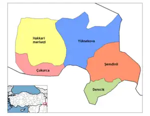
Derecik District | |
|---|---|
 Map showing Derecik District in Hakkâri Province | |
| Country | Turkey |
| Province | Hakkâri |
| Seat | Derecik |
| Government | |
| • Kaymakam | Abdulkadir Işık |
| Area | 435 km2 (168 sq mi) |
| Population (2022) | 23,461 |
| • Density | 54/km2 (140/sq mi) |
| Time zone | TRT (UTC+3) |
| Website | www |
Derecik District is a district in Hakkâri Province in Turkey. The district was created from Şemdinli in 2018 and has four villages.[1][2] The district had a population of 23,461 in 2022.[3] Its area is 435 km2.[4]
The district is populated by Kurds of the Gerdî tribe with the Begzade tribe present in one village.[5][6]
It borders the Erbil Governorate of Kurdistan Region in Iraq to the south and the local Gerdî tribe shares closer traditions and customs with the Gerdî Kurds residing on the Iraqi side than the Kurds of Yüksekova and Hakkâri.[7]
Settlements
The main town of the district is Derecik (Rûbarok).
The four villages of the district:
The sixteen hamlets of the district:[8]
- Adıgüzel
- Akören (Bêşan)
- Aralık (Parewê)
- Bağlıca (Mamreşan)
- Beğendik
- Beşikağaç (Nihave)
- Bölek (Serekanî)
- Gökçetaş (Musekan)
- Karakoç (Sunê)
- Koryürek (Bêgijnê)
- Kütüklu (Zewyarezi)
- Mordağ (Dêrkê)
- Ormancık (Bêgalte)
- Örencık (Benavok)
- Suçıktı (Bêlutyan)
- Taşlıçay (Çemena geli)
- Toklu
- Ulaşan (Zerin)
- Yeşilova (Îsyan)
Population
Population history of the district from 2018 to 2022:[9]
| Year | Pop. | ±% |
|---|---|---|
| 2018 | 22,953 | — |
| 2019 | 23,377 | +1.8% |
| 2020 | 22,988 | −1.7% |
| 2021 | 23,140 | +0.7% |
| 2022 | 23,461 | +1.4% |
References
- ↑ "Hakkari Valisi Akbıyık, yeni ilçe olan Derecik'i ziyaret etti". T24 (in Turkish). 29 November 2018. Retrieved 1 October 2022.
- ↑ "Türkiye Mülki İdare Bölümleri Envanteri". T.C. İçişleri Bakanlığı (in Turkish). Retrieved 19 December 2022.
- ↑ "31 ARALIK 2021 TARİHLİ ADRESE DAYALI NÜFUS KAYIT SİSTEMİ (ADNKS) SONUÇLARI" (XLS). TÜİK (in Turkish). Retrieved 16 December 2022.
- ↑ "İl ve İlçe Yüz ölçümleri". General Directorate of Mapping. Retrieved 1 March 2023.
- ↑ Erdost, Muzaffer İlhan (1993). Şemdinli röportajı (in Turkish). Onur Yayınları. pp. 292, 306.
- ↑ Peter Alfred, Andrews; Benninghaus, Rüdiger, eds. (1989). Ethnic Groups in the Republic of Turkey. pp. 216–217.
- ↑ Aras, Ramazan (2020). The Wall: The Making and Unmaking of the Turkish-Syrian Border. Springer Nature. p. 125.
- ↑ "Derecik köylerinin Kürtçe, Türkçe ve eski isimleri". Yüksekova Haber (in Turkish). Retrieved 15 December 2022.
- ↑ "Address Based Population Registration System Results". Türkiye İstatistik Kurumu (in Turkish). Retrieved 15 February 2023.
This article is issued from Wikipedia. The text is licensed under Creative Commons - Attribution - Sharealike. Additional terms may apply for the media files.