| Dionisio Point Provincial Park | |
|---|---|
 Map of British Columbia | |
| Location | Cowichan Land District, British Columbia, Canada |
| Nearest city | Ladysmith, BC |
| Coordinates | 49°00′24″N 123°34′29″W / 49.00667°N 123.57472°W |
| Area | 142 ha. (1.42 km²) |
| Established | July 31, 1991 |
| Governing body | BC Parks |
| Website | bcparks |
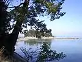
Dionisio Point Provincial Park is a provincial park campground in the southern Gulf Islands of British Columbia, Canada. It is located at the northwestern tip of Galiano Island, across Porlier Pass from Valdes Island.
 Dionisio Point


 Porlier Pass
External links
This article is issued from Wikipedia. The text is licensed under Creative Commons - Attribution - Sharealike. Additional terms may apply for the media files.