Dyjákovice | |
|---|---|
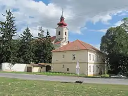 Church of Saint Michael and the municipal office | |
 Flag  Coat of arms | |
 Dyjákovice Location in the Czech Republic | |
| Coordinates: 48°46′19″N 16°18′3″E / 48.77194°N 16.30083°E | |
| Country | |
| Region | South Moravian |
| District | Znojmo |
| First mentioned | 1278 |
| Area | |
| • Total | 19.30 km2 (7.45 sq mi) |
| Elevation | 185 m (607 ft) |
| Population (2023-01-01)[1] | |
| • Total | 928 |
| • Density | 48/km2 (120/sq mi) |
| Time zone | UTC+1 (CET) |
| • Summer (DST) | UTC+2 (CEST) |
| Postal code | 671 26 |
| Website | www |
Dyjákovice (German: Groß Tajax) is a municipality and village in Znojmo District in the South Moravian Region of the Czech Republic. It has about 800 inhabitants.
Dyjákovice lies approximately 22 kilometres (14 mi) south-east of Znojmo, 53 km (33 mi) south-west of Brno, and 200 km (120 mi) south-east of Prague.
History
The first written mention of Dyjákovice is from 1278.[2]
Demographics
|
|
| ||||||||||||||||||||||||||||||||||||||||||||||||||||||
| Source: Censuses[3][4] | ||||||||||||||||||||||||||||||||||||||||||||||||||||||||
References
- ↑ "Population of Municipalities – 1 January 2023". Czech Statistical Office. 2023-05-23.
- ↑ "Z historie obce" (in Czech). Obec Dyjákovice. Retrieved 2021-11-23.
- ↑ "Historický lexikon obcí České republiky 1869–2011 – Okres Znojmo" (in Czech). Czech Statistical Office. 2015-12-21. pp. 1–2.
- ↑ "Population Census 2021: Population by sex". Public Database. Czech Statistical Office. 2021-03-27.
External links
Wikimedia Commons has media related to Dyjákovice.
This article is issued from Wikipedia. The text is licensed under Creative Commons - Attribution - Sharealike. Additional terms may apply for the media files.