Horní Dunajovice | |
|---|---|
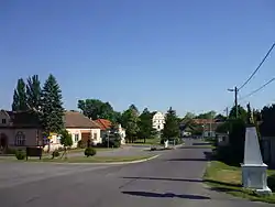 Centre of Horní Dunajovice | |
 Coat of arms | |
 Horní Dunajovice Location in the Czech Republic | |
| Coordinates: 48°57′1″N 16°9′41″E / 48.95028°N 16.16139°E | |
| Country | |
| Region | South Moravian |
| District | Znojmo |
| First mentioned | 1358 |
| Area | |
| • Total | 10.05 km2 (3.88 sq mi) |
| Elevation | 237 m (778 ft) |
| Population (2023-01-01)[1] | |
| • Total | 623 |
| • Density | 62/km2 (160/sq mi) |
| Time zone | UTC+1 (CET) |
| • Summer (DST) | UTC+2 (CEST) |
| Postal code | 671 34 |
| Website | www |
Horní Dunajovice is a municipality and village in Znojmo District in the South Moravian Region of the Czech Republic. It has about 600 inhabitants.
Horní Dunajovice lies approximately 15 kilometres (9 mi) north-east of Znojmo, 43 km (27 mi) south-west of Brno, and 179 km (111 mi) south-east of Prague.
References
Wikimedia Commons has media related to Horní Dunajovice.
This article is issued from Wikipedia. The text is licensed under Creative Commons - Attribution - Sharealike. Additional terms may apply for the media files.