Zálesí | |
|---|---|
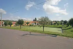 Centre of Zálesí | |
 Flag  Coat of arms | |
 Zálesí Location in the Czech Republic | |
| Coordinates: 48°57′15″N 15°46′55″E / 48.95417°N 15.78194°E | |
| Country | |
| Region | South Moravian |
| District | Znojmo |
| First mentioned | 1786 |
| Area | |
| • Total | 7.18 km2 (2.77 sq mi) |
| Elevation | 431 m (1,414 ft) |
| Population (2023-01-01)[1] | |
| • Total | 154 |
| • Density | 21/km2 (56/sq mi) |
| Time zone | UTC+1 (CET) |
| • Summer (DST) | UTC+2 (CEST) |
| Postal code | 671 02 |
| Website | www |
Zálesí is a municipality and village in Znojmo District in the South Moravian Region of the Czech Republic. It has about 200 inhabitants.
Zálesí lies approximately 23 kilometres (14 mi) north-west of Znojmo, 66 km (41 mi) south-west of Brno, and 159 km (99 mi) south-east of Prague.
References
Wikimedia Commons has media related to Zálesí.
This article is issued from Wikipedia. The text is licensed under Creative Commons - Attribution - Sharealike. Additional terms may apply for the media files.