Genhe
根河市 • ᢉᢉᠠᠠ ᠭᠣᠤᠯ ᠬᠣᠲᠠ | |
|---|---|
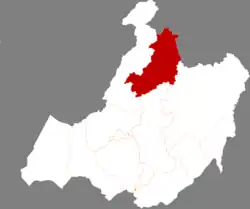
 Location of Genhe in Hulunbuir City | |
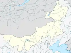
 Genhe Location of the city centre in Inner Mongolia  Genhe Genhe (China) | |
| Coordinates: 50°47′N 121°31′E / 50.783°N 121.517°E | |
| Country | China |
| Autonomous region | Inner Mongolia |
| Prefecture-level city | Hulunbuir |
| Municipal seat | Hexi Subdistrict |
| Area | |
| • County-level city | 19,659.0 km2 (7,590.4 sq mi) |
| • Urban | 350.00 km2 (135.14 sq mi) |
| Elevation | 714 m (2,343 ft) |
| Population (2020)[2] | |
| • County-level city | 71,437 |
| • Density | 3.6/km2 (9.4/sq mi) |
| • Urban | 64,400 |
| Time zone | UTC+8 (China Standard) |
| Postal code | 022300 |
| Area code | 0470 |
| Website | www |
| Genhe | |||||||
|---|---|---|---|---|---|---|---|
| Chinese name | |||||||
| Chinese | 根河市 | ||||||
| |||||||
| Former name | |||||||
| Simplified Chinese | 额尔古纳左旗 | ||||||
| Traditional Chinese | 額爾古納左旗 | ||||||
| |||||||
| Mongolian name | |||||||
| Mongolian Cyrillic | Гэгээнгол хот | ||||||
| Mongolian script | ᠭᠡᠭᠡᠨ ᠭᠣᠤᠯ ᠬᠣᠲᠠ | ||||||
| |||||||
Genhe City or Gegengol (Mongolian: ᠭᠡᠭᠡᠨ ᠭᠣᠤᠯ ᠬᠣᠲᠠ; Chinese: 根河市), formerly Ergun Left Banner (Chinese: 额尔古纳左旗), is a county-level city in the far northeast of Inner Mongolia, China, under the administration of Hulunbuir City. The city spans an area of 19,659 square kilometres (7,590 sq mi),[1] and has a total population of 130,722 as of 2019.[3]: 20–1
Geography and climate

Genhe has a monsoon-influenced subarctic climate (Köppen Dwc), making it one of the coldest locations nationally, with an annual mean temperature of −3.56 °C (25.6 °F). Winters are long, severely cold, and very dry in terms of total precipitation, while summers are short and warm; the normal monthly mean temperature ranges from −28.1 °C (−18.6 °F) in January to 17.6 °C (63.7 °F) in July. Over two-thirds of the annual precipitation of 438 mm (17.2 in) is distributed from June through August.
| Climate data for Genhe (2005–2020 normals, extremes 1981–2010) | |||||||||||||
|---|---|---|---|---|---|---|---|---|---|---|---|---|---|
| Month | Jan | Feb | Mar | Apr | May | Jun | Jul | Aug | Sep | Oct | Nov | Dec | Year |
| Record high °C (°F) | −4.7 (23.5) |
2.5 (36.5) |
15.2 (59.4) |
24.4 (75.9) |
34.5 (94.1) |
34.5 (94.1) |
35.7 (96.3) |
33.3 (91.9) |
31.4 (88.5) |
24.8 (76.6) |
7.8 (46.0) |
−4.3 (24.3) |
35.7 (96.3) |
| Mean daily maximum °C (°F) | −19.0 (−2.2) |
−12.2 (10.0) |
−2.0 (28.4) |
8.6 (47.5) |
17.7 (63.9) |
23.6 (74.5) |
25.7 (78.3) |
23.3 (73.9) |
17.2 (63.0) |
6.6 (43.9) |
−7.6 (18.3) |
−18.4 (−1.1) |
5.3 (41.5) |
| Daily mean °C (°F) | −27.7 (−17.9) |
−22.8 (−9.0) |
−11.4 (11.5) |
1.0 (33.8) |
9.8 (49.6) |
15.7 (60.3) |
18.4 (65.1) |
15.7 (60.3) |
8.3 (46.9) |
−1.8 (28.8) |
−15.6 (3.9) |
−25.8 (−14.4) |
−3.0 (26.6) |
| Mean daily minimum °C (°F) | −34.3 (−29.7) |
−31.3 (−24.3) |
−20.5 (−4.9) |
−7.3 (18.9) |
1.1 (34.0) |
7.4 (45.3) |
11.7 (53.1) |
9.6 (49.3) |
1.5 (34.7) |
−8.4 (16.9) |
−21.8 (−7.2) |
−31.4 (−24.5) |
−10.3 (13.5) |
| Record low °C (°F) | −46.1 (−51.0) |
−47.5 (−53.5) |
−39.5 (−39.1) |
−26.6 (−15.9) |
−14.7 (5.5) |
−4.5 (23.9) |
0.9 (33.6) |
−3.1 (26.4) |
−11.7 (10.9) |
−26.4 (−15.5) |
−42.0 (−43.6) |
−45.2 (−49.4) |
−47.5 (−53.5) |
| Average precipitation mm (inches) | 3.7 (0.15) |
3.2 (0.13) |
5.7 (0.22) |
17.4 (0.69) |
39.9 (1.57) |
81.0 (3.19) |
129.8 (5.11) |
98.6 (3.88) |
50.0 (1.97) |
14.9 (0.59) |
9.2 (0.36) |
6.2 (0.24) |
459.6 (18.1) |
| Average precipitation days (≥ 0.1 mm) | 6.5 | 5.7 | 6.1 | 7.3 | 11.2 | 15.9 | 16.9 | 15.9 | 11.2 | 7.1 | 9.4 | 9.2 | 122.4 |
| Average snowy days | 9.3 | 8.8 | 10.1 | 8.1 | 1.5 | 0.1 | 0 | 0 | 1.1 | 7.8 | 13.8 | 14.1 | 74.7 |
| Average relative humidity (%) | 67 | 64 | 60 | 50 | 52 | 68 | 75 | 78 | 72 | 65 | 71 | 71 | 66 |
| Mean monthly sunshine hours | 148.2 | 189.7 | 258.7 | 254.3 | 245.7 | 236.2 | 230.4 | 207.8 | 205.6 | 181.7 | 141.3 | 112.3 | 2,411.9 |
| Percent possible sunshine | 56 | 66 | 70 | 61 | 51 | 48 | 47 | 47 | 55 | 56 | 54 | 46 | 55 |
| Source: China Meteorological Administration[4][5] | |||||||||||||
Administrative divisions
Genhe is divided into 4 subdistricts, 4 towns, and 1 ethnic township.[6][7]
| Name | Simplified Chinese | Hanyu Pinyin | Mongolian (Hudum Script) | Mongolian (Cyrillic) | Administrative division code |
|---|---|---|---|---|---|
| Subdistricts | |||||
| Hedong Subdistrict | 河东街道 | Hédōng Jiēdào | ᠾᠧ ᠳ᠋ᠦᠩ ᠵᠡᠭᠡᠯᠢ ᠭᠤᠳᠢᠮᠵᠢ | Ге дүн зээл гудимж | 150785001 |
| Hexi Subdistrict | 河西街道 | Héxī Jiēdào | ᠾᠧ ᠰᠢ ᠵᠡᠭᠡᠯᠢ ᠭᠤᠳᠤᠮᠵᠢ | Ге ший зээл гудамж | 150785002 |
| Sengong Subdistrict | 森工街道 | Sēngōng Jiēdào | ᠰᠧᠨᠭᠦ᠋ᠩ ᠵᠡᠭᠡᠯᠢ ᠭᠤᠳᠤᠮᠵᠢ | Сенхүн зээл гудамж | 150785003 |
| Holbo Subdistrict | 好里堡街道 | Hǎolǐbǎo Jiēdào | ᠬᠣᠯᠢᠪᠥ᠋ ᠵᠡᠭᠡᠯᠢ ᠭᠤᠳᠤᠮᠵᠢ | Холив зээл гудамж | 150785004 |
| Towns | |||||
| Jinhe Town | 金河镇 | Jīnhé Zhèn | ᠵᠢᠨ ᠾᠧ ᠪᠠᠯᠭᠠᠰᠤ | Гийн ге балгас | 150785101 |
| Alongshan Town | 阿龙山镇 | Ālóngshān Zhèn | ᠠᠯᠦ᠋ᠩᠱᠠᠨ ᠪᠠᠯᠭᠠᠰᠤ | Алуншин балгас | 150785102 |
| Mangui Town | 满归镇 | Mǎnguī Zhèn | ᠮᠠᠨᠭᠦᠢ ᠪᠠᠯᠭᠠᠰᠤ | Мангүй балгас | 150785103 |
| Delbur Town | 得耳布尔镇 | Dé'ěrbù'ěr Zhèn | ᠳ᠋ᠧᠯᠪᠤᠷ ᠪᠠᠯᠭᠠᠰᠤ | Тельбор балгас | 150785104 |
| Ethnic Township | |||||
| Olguya Evenk Ethnic Township | 敖鲁古雅鄂温克民族乡 | Áolǔgǔyǎ Èwēnkè Mínzúxiāng | ᠣᠯᠭᠤᠶᠠ ᠡᠸᠡᠩᠬᠢ ᠦᠨᠳᠦᠰᠦᠲᠡᠨ ᠦ ᠰᠢᠶᠠᠩ | Олгоё эвэнк үндэстэний шиян | 150785200 |
Demographics
As of 2019, Genhe is home to 130,722 inhabitants, the 72nd most of Inner Mongolia's 103 county-level divisions.[3]: 20–1 As of 2017, 64,400 of Genhe's residents lived in urban areas.[1]
Economy
Genhe's gross domestic product in 2019 totaled 3,200,870,000 renminbi (RMB), growing at a rate of 2.0% over 2018.[3]: 20–38 Of this, 16.87% came from the city's primary sector, 18.04% came from the city's secondary sector, and 65.09% came from the city's tertiary sector.[3]: 20–38
Consumer retail sales in Genhe for 2019 totaled 2,305,160,000 RMB.[3]: 20–38
Households in Genhe earned, on average, 28,375 RMB in disposable income in 2019.[3]: 20–38
Genhe reported 71,030,000 RMB in public budget revenue in 2019, the lowest of Inner Mongolia's 103 county-level divisions.[3]: 20–4
As of 2019, there are 119,000 mobile phone subscriptions and 29,200 internet subscriptions in Genhe.[3]: 20–38
Agriculture
In 2019, Genhe produced 5,000 tons of grain, ranking 86th among the 96 county-level divisions in Inner Mongolia which reported this statistic.[3]: 20–2 The city also produced 1,167 tons of meat in 2019, ranking 97th among the Inner Mongolia's 103 county-level divisions.[3]: 20–3
Education
As of 2019, Genhe has seven primary schools and nine secondary schools.[3]: 20–38
Healthcare
Genhe's medical institutions have 477 beds staffed by 942 personnel, as of 2019.[3]: 20–38
Culture
A small number of ethnic Evenk reindeer herders remain in the city's Aoluguya Evenk Ethnic Township.[7]
Transportation
2,698 kilometres (1,676 mi) of highway run through Genhe as of 2019.[3]: 20–38
References
- 1 2 3 4 Ministry of Housing and Urban-Rural Development, ed. (2019). China Urban Construction Statistical Yearbook 2017. Beijing: China Statistics Press. p. 46. Archived from the original on 18 June 2019. Retrieved 11 January 2020.
- ↑ Inner Mongolia: Prefectures, Cities, Districts and Counties
- 1 2 3 4 5 6 7 8 9 10 11 12 13 内蒙古统计年鉴—2020 [Inner Mongolia Statistical Yearbook 2020]. tj.nmg.gov.cn (in Chinese). Inner Mongolia Autonomous Regional Bureau of Statistics. 2020. Archived from the original on 2021-07-13. Retrieved 2021-07-13.
- ↑ 中国气象数据网 – WeatherBk Data (in Simplified Chinese). China Meteorological Administration. Retrieved 10 October 2023.
- ↑ 中国气象数据网 (in Simplified Chinese). China Meteorological Administration. Retrieved 10 October 2023.
- ↑ 2022年统计用区划代码 (in Chinese). National Bureau of Statistics of China. 2019.
- 1 2 Wang, Wei (2019-11-07). 中国最后的驯鹿部落——敖鲁古雅 [China's Last Reindeer Tribe——Aoluguya]. society.people.com.cn (in Chinese). Archived from the original on 2020-10-06. Retrieved 2020-10-06.