Holingol
霍林郭勒市 • ᠬᠣᠣᠯᠢᠠ ᠭᠣᠤᠯ ᠬᠣᠲᠠ | |
|---|---|
 | |
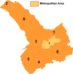
 Tongliao divisions: Holingol is 2 on this map | |
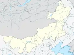
 Holingol Location in Inner Mongolia  Holingol Holingol (China) | |
| Coordinates: 45°32′00″N 119°39′10″E / 45.53333°N 119.65278°E | |
| Country | China |
| Autonomous region | Inner Mongolia |
| Prefecture-level city | Tongliao |
| Municipal seat | Mostai Subdistrict |
| Area | |
| • County-level city | 585.0 km2 (225.9 sq mi) |
| • Urban | 36.04 km2 (13.92 sq mi) |
| Population (2020)[2] | |
| • County-level city | 138,676 |
| • Density | 240/km2 (610/sq mi) |
| Time zone | UTC+8 (China Standard) |
| Postal code | 029200 |
| Area code | 0475 |
| GDP | 2008 |
| - Total | CNY 13.1 billion USD 2.01 billion |
| - Per capita | CNY 187,142 USD 29,052 |
| Website | www |
| Holingol | |||||||
|---|---|---|---|---|---|---|---|
| Chinese name | |||||||
| Chinese | 霍林郭勒市 | ||||||
| |||||||
| Mongolian name | |||||||
| Mongolian Cyrillic | Хоолингол хот | ||||||
| Mongolian script | ᠬᠣᠣᠯᠢᠠ ᠭᠣᠤᠯ ᠬᠣᠲᠠ | ||||||
Holingol (also Huolin Gol; Mongolian: ᠬᠣᠣᠯᠢᠠ ᠭᠣᠤᠯ ᠬᠣᠲᠠ; Chinese: 霍林郭勒) is a county-level city of Inner Mongolia, China.
It has a population of more than 70,000, which includes 17 ethnic groups. It is the northernmost and westernmost county-level division of Tongliao.
Administrative divisions
Holingol is made up of 4 subdistricts and 1 sum.
| Name | Simplified Chinese | Hanyu Pinyin | Mongolian (Hudum Script) | Mongolian (Cyrillic) | Administrative division code |
|---|---|---|---|---|---|
| Subdistricts | |||||
| Jus Hua Subdistrict | 珠斯花街道 | Zhūsīhuā Jiēdào | ᠵᠦᠰᠬᠤᠸᠠ ᠵᠡᠭᠡᠯᠢ ᠭᠤᠳᠤᠮᠵᠢ | Зүсхуа зээл гудамж | 150581001 |
| Mostai Subdistrict | 莫斯台街道 | Mòsītái Jiēdào | ᠮᠥᠰᠥᠲᠥ ᠵᠡᠭᠡᠯᠢ ᠭᠤᠳᠤᠮᠵᠢ | Мөст зээл гудамж | 150581002 |
| Bor Hujir Subdistrict | 宝日呼吉尔街道 | Bǎorìhūjí'ěr Jiēdào | ᠪᠣᠷᠬᠤᠵᠢᠷ ᠵᠡᠭᠡᠯᠢ ᠭᠤᠳᠤᠮᠵᠢ | Борхожир зээл гудамж | 150581003 |
| Xarhur Subdistrict | 沙尔呼热街道 | Shā'ěrhūrè Jiēdào | ᠰᠢᠷᠠ ᠬᠦᠦᠷ ᠵᠡᠭᠡᠯᠢ ᠭᠤᠳᠤᠮᠵᠢ | Шар гүүр зээл гудамж | 150581004 |
| Sum | |||||
| Dalai Huxu Sum | 达来胡硕苏木 | Dáláihúshuò Sūmù | ᠳᠠᠯᠠᠢᠬᠤᠰᠢᠭᠤ ᠰᠤᠮᠤ | Далайхашуу сум | 150581200 |
Other: Holingol Military Horse Farm Ecological Reserve Management Committee (霍林郭勒市军马场生态保护区管理委员会)
Climate
| Climate data for Holingol (2006–2020 normals) | |||||||||||||
|---|---|---|---|---|---|---|---|---|---|---|---|---|---|
| Month | Jan | Feb | Mar | Apr | May | Jun | Jul | Aug | Sep | Oct | Nov | Dec | Year |
| Mean daily maximum °C (°F) | −13.9 (7.0) |
−8.9 (16.0) |
0.5 (32.9) |
11.3 (52.3) |
19.6 (67.3) |
24.3 (75.7) |
27.0 (80.6) |
25.5 (77.9) |
19.7 (67.5) |
10.6 (51.1) |
−2.3 (27.9) |
−11.9 (10.6) |
8.5 (47.2) |
| Daily mean °C (°F) | −19.0 (−2.2) |
−15.1 (4.8) |
−5.9 (21.4) |
4.3 (39.7) |
12.6 (54.7) |
17.9 (64.2) |
20.9 (69.6) |
18.9 (66.0) |
12.3 (54.1) |
3.3 (37.9) |
−8.0 (17.6) |
−16.6 (2.1) |
2.1 (35.8) |
| Mean daily minimum °C (°F) | −23.3 (−9.9) |
−20.4 (−4.7) |
−12.0 (10.4) |
−2.7 (27.1) |
5.1 (41.2) |
11.3 (52.3) |
14.9 (58.8) |
12.7 (54.9) |
5.6 (42.1) |
−2.8 (27.0) |
−12.8 (9.0) |
−20.7 (−5.3) |
−3.8 (25.2) |
| Average precipitation mm (inches) | 1.6 (0.06) |
2.5 (0.10) |
5.9 (0.23) |
9.0 (0.35) |
34.9 (1.37) |
68.6 (2.70) |
97.4 (3.83) |
73.1 (2.88) |
43.1 (1.70) |
14.6 (0.57) |
5.8 (0.23) |
3.7 (0.15) |
360.2 (14.17) |
| Average precipitation days (≥ 0.1 mm) | 3.3 | 3.3 | 5.1 | 5.7 | 8.3 | 13.4 | 13.5 | 10.5 | 8.7 | 5.0 | 5.1 | 5.7 | 87.6 |
| Average snowy days | 9.3 | 8.0 | 9.7 | 4.6 | 0.9 | 0 | 0 | 0 | 0.5 | 4.7 | 9.9 | 12.3 | 59.9 |
| Average relative humidity (%) | 67 | 64 | 57 | 43 | 44 | 59 | 66 | 66 | 59 | 55 | 63 | 68 | 59 |
| Mean monthly sunshine hours | 201.5 | 221.0 | 271.8 | 271.4 | 268.0 | 231.6 | 229.3 | 247.7 | 236.0 | 231.0 | 184.8 | 170.6 | 2,764.7 |
| Percent possible sunshine | 71 | 75 | 73 | 66 | 58 | 50 | 49 | 57 | 64 | 69 | 66 | 63 | 63 |
| Source: China Meteorological Administration[3][4] | |||||||||||||
Transport
- China National Highway 304
- Inner Mongolia Provincial Highway 101
- Tonghuo Railway
- Huolinhe Airport
Economy
- GDP: RMB ¥1.82 billion in 2004, RMB ¥5 billion in 2006, RMB ¥13.1 billion in 2008
- Pillar industries: stockbreeding, mining, tourism
- Composition of GDP in 2008: ¥0.16 billion in primary industry, ¥9.35 billion in secondary industry, ¥3.59 billion in third industry.
Education
- At year-end of 2006, there are 15 primary and secondary schools and 5 kindergartens in the city.
- Number of students enrolled at year-end of 2006: 896 in kindergartens, 10637 in primary schools, 3049 in junior high schools, 2112 in senior high schools.
- Number of teachers at year-end of 2006: 1177 full-time teachers
- Percentage of children of the right age attending primary school in 2006: 100%
- Percentage of primary school graduates entering a higher school in 2006: 100%
- Percentage of junior high graduates entering a higher school in 2006: 95.24%
Health
- Number of medical entities at year-end of 2006: 4
- Number of health-care entities at year-end of 2006: 2
- Number of hospital beds at year-end of 2006: 238
- Number of medical doctors, registered nurses and medical technicians at year end of 2006: 420
References
- ↑ Ministry of Housing and Urban-Rural Development, ed. (2019). China Urban Construction Statistical Yearbook 2017. Beijing: China Statistics Press. p. 46. Retrieved 11 January 2020.
- ↑ Inner Mongolia: Prefectures, Cities, Districts and Counties
- ↑ 中国气象数据网 – WeatherBk Data (in Simplified Chinese). China Meteorological Administration. Retrieved 10 October 2023.
- ↑ 中国气象数据网 (in Simplified Chinese). China Meteorological Administration. Retrieved 10 October 2023.
External links
This article is issued from Wikipedia. The text is licensed under Creative Commons - Attribution - Sharealike. Additional terms may apply for the media files.