Huriel | |
|---|---|
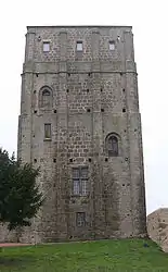 Roman keep | |
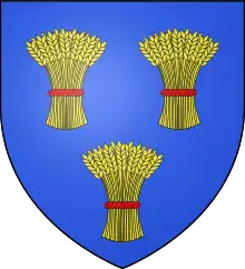 Coat of arms | |
Location of Huriel | |
 Huriel  Huriel | |
| Coordinates: 46°22′26″N 2°28′39″E / 46.3739°N 2.4775°E | |
| Country | France |
| Region | Auvergne-Rhône-Alpes |
| Department | Allier |
| Arrondissement | Montluçon |
| Canton | Huriel |
| Intercommunality | Pays d'Huriel |
| Government | |
| • Mayor (2020–2026) | Stéphane Abranowitch[1] |
| Area 1 | 34.92 km2 (13.48 sq mi) |
| Population | 2,600 |
| • Density | 74/km2 (190/sq mi) |
| Time zone | UTC+01:00 (CET) |
| • Summer (DST) | UTC+02:00 (CEST) |
| INSEE/Postal code | 03128 /03380 |
| Elevation | 210–418 m (689–1,371 ft) (avg. 332 m or 1,089 ft) |
| 1 French Land Register data, which excludes lakes, ponds, glaciers > 1 km2 (0.386 sq mi or 247 acres) and river estuaries. | |
Huriel (French pronunciation: [yʁjɛl]; Occitan: Uriac) is a commune in the Allier department in central France.
Population
| Year | Pop. | ±% p.a. |
|---|---|---|
| 1968 | 2,237 | — |
| 1975 | 2,147 | −0.58% |
| 1982 | 2,347 | +1.28% |
| 1990 | 2,606 | +1.32% |
| 1999 | 2,377 | −1.02% |
| 2007 | 2,460 | +0.43% |
| 2012 | 2,663 | +1.60% |
| 2017 | 2,646 | −0.13% |
| Source: INSEE[3] | ||
See also
References
- ↑ "Répertoire national des élus: les maires" (in French). data.gouv.fr, Plateforme ouverte des données publiques françaises. 13 September 2022.
- ↑ "Populations légales 2021". The National Institute of Statistics and Economic Studies. 28 December 2023.
- ↑ Population en historique depuis 1968, INSEE
Wikimedia Commons has media related to Huriel.
This article is issued from Wikipedia. The text is licensed under Creative Commons - Attribution - Sharealike. Additional terms may apply for the media files.