Javorník | |
|---|---|
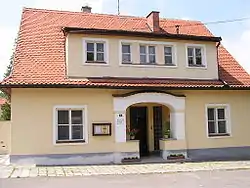 Protestant rectory | |
 Flag  Coat of arms | |
 Javorník Location in the Czech Republic | |
| Coordinates: 48°51′43″N 17°32′0″E / 48.86194°N 17.53333°E | |
| Country | |
| Region | South Moravian |
| District | Hodonín |
| First mentioned | 1350 |
| Area | |
| • Total | 24.45 km2 (9.44 sq mi) |
| Elevation | 312 m (1,024 ft) |
| Population (2023-01-01)[1] | |
| • Total | 690 |
| • Density | 28/km2 (73/sq mi) |
| Time zone | UTC+1 (CET) |
| • Summer (DST) | UTC+2 (CEST) |
| Postal code | 696 74 |
| Website | www |
Javorník is a municipality and village in Hodonín District in the South Moravian Region of the Czech Republic. It has about 700 inhabitants.
Javorník, a part of traditional ethnographic region Horňácko, lies approximately 30 kilometres (19 mi) east of Hodonín, 77 km (48 mi) south-east of Brno, and 263 km (163 mi) south-east of Prague.
References
Wikimedia Commons has media related to Javorník (Hodonín District).
This article is issued from Wikipedia. The text is licensed under Creative Commons - Attribution - Sharealike. Additional terms may apply for the media files.