Ostrovánky | |
|---|---|
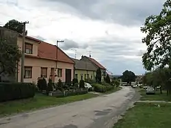 Main street | |
 Flag  Coat of arms | |
 Ostrovánky Location in the Czech Republic | |
| Coordinates: 49°2′34″N 17°4′49″E / 49.04278°N 17.08028°E | |
| Country | |
| Region | South Moravian |
| District | Hodonín |
| First mentioned | 1141 |
| Area | |
| • Total | 1.63 km2 (0.63 sq mi) |
| Elevation | 309 m (1,014 ft) |
| Population (2023-01-01)[1] | |
| • Total | 228 |
| • Density | 140/km2 (360/sq mi) |
| Time zone | UTC+1 (CET) |
| • Summer (DST) | UTC+2 (CEST) |
| Postal code | 696 31 |
| Website | www |
Ostrovánky is a municipality and village in Hodonín District in the South Moravian Region of the Czech Republic. It has about 200 inhabitants.
Ostrovánky lies approximately 22 kilometres (14 mi) north of Hodonín, 39 km (24 mi) south-east of Brno, and 225 km (140 mi) south-east of Prague.
References
Wikimedia Commons has media related to Ostrovánky.
This article is issued from Wikipedia. The text is licensed under Creative Commons - Attribution - Sharealike. Additional terms may apply for the media files.