| Kakita River | |
|---|---|
 | |
| Native name | 柿田川 (Japanese) |
| Location | |
| Country | Japan |
| Physical characteristics | |
| Length | 1.2 km (0.75 mi) |
The Kakita River (柿田川, Kakita-gawa) is a river flowing through the town of Shimizu in the Suntō District, Shizuoka Prefecture, Japan.
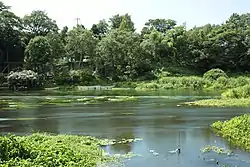
The Kakita River is a tributary of the Kano River. At only 1.2 km (1 mi), it is the shortest Class 1 River in Japan.[1]
.jpg.webp)
Kano River (Below)

Most of the river's source water comes from springs created by rainfall and melting snow on Mount Fuji. Therefore, the temperature of the river is around 15 °C throughout the year. The river is also known as the only habitat of Mishima-baikamo (ja:ミシマバイカモ). The area around the springs is protected as a park (Kakita River Park (柿田川公園, Kakita-gawa Kōen) by the Shimizu town government.
Also, famous for being a clear-flowing river, the Kakita River has been named one of the "Three Clear-Flowing Rivers in Japan", along with the Nagara River in Gifu Prefecture and the Shimanto River in Kōchi Prefecture.
References
- ↑ Wonderland Kakita River Archived 2008-05-11 at the Wayback Machine. (in Japanese) Shimizu Chamber of Commerce. Accessed May 19, 2008.
External links
35°05′54″N 138°54′01″E / 35.09827°N 138.900333°E (flow into Kano River)
- Information Kanogawa - Ministry of Land, Infrastructure and Transport NUMAZU Office.
- Kakita River webcam - showing underwater spring.
| |||||||||||||||
| |||||||||||||||
| |||||||||||||||
| |||||||||||||||
| |||||||||||||||