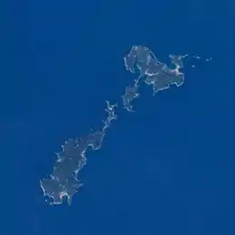
Native name: 甑島列島 Koshikishima Rettō | |
|---|---|
 | |
 Koshikijima Islands Location in Japan | |
| Geography | |
| Location | East China Sea |
| Coordinates | 31°45′12″N 129°47′03″E / 31.75328°N 129.78424°E |
| Archipelago | yes |
| Total islands | 11 |
| Major islands | 3 |
| Area | 118.68 km2 (45.82 sq mi) |
| Length | 39 km (24.2 mi) |
| Width | 11 km (6.8 mi) |
| Administration | |
Japan | |
| Prefecture | Kagoshima Prefecture |
| City | Satsumasendai |
| Demographics | |
| Population | 5576 (2010) |
| Pop. density | 47/km2 (122/sq mi) |
| Ethnic groups | Japanese |
The Koshikijima Islands (甑島列島, Koshikishima-rettō[1]) in the East China Sea are an island chain located 38 kilometres (21 nmi; 24 mi) west of the port city of Ichikikushikino, Kagoshima.
Major islands
| Island | Coordinates | area, km² | population (2010) |
|---|---|---|---|
| Kamikoshiki-jima (上甑島) | 31°50′05″N 129°53′20″E / 31.834790°N 129.888989°E | 45.08 | 2488 |
| Naka-Koshiki-jima (中甑島) | 31°48′08″N 129°49′38″E / 31.802107°N 129.827191°E | 7.29 | 308 |
| Shimokoshiki-jima (下甑島) | 31°42′15″N 129°43′25″E / 31.704047°N 129.723703°E | 66.27 | 2780 |
Minor islands
All minor islands are currently (as of 2017) uninhabited.
| Island | Coordinates | area, km² |
|---|---|---|
| No-jima (野島) | 31°51′58″N 129°57′38″E / 31.866071°N 129.960427°E | 0.11 |
| Chika-jima (近島) | 31°51′05″N 129°57′01″E / 31.851494°N 129.950236°E | 0.10 |
| Futago-jima (双子島) | 31°51′44″N 129°58′34″E / 31.862180°N 129.976023°E | 0.05 |
| Okinoshima (沖の島) | 31°51′52″N 129°59′03″E / 31.864498°N 129.984074°E | 0.02 |
| Benkei-jima (弁慶島)# | 31°46′25″N 129°50′04″E / 31.773680°N 129.834574°E | 0.02 |
| Kasetō (筒島) | 31°52′01″N 129°57′12″E / 31.866938°N 129.953346°E | 0.02 |
| Napoleon Rock | 31°42′11″N 129°41′14″E / 31.703060°N 129.687216°E | 0.01 |
| Yurashima (由良島)[2] | 31°44′35″N 129°45′19″E / 31.743005°N 129.755239°E | 0.01 |
| Matsushima (松島) | 31°52′00″N 129°56′54″E / 31.866748°N 129.948315°E | 0.004 |
- seems to undergo significant erosion and may disappear
History
The islands once consisted of 14 villages, belonging to Shikijima-gun, Satsuma Province (Satsuma no Kuni) during the Meiji period. In 1889, the islands were consolidated into Kami-Koshiki and Shimo-Koshiki villages. In 1897, the islands were merged with Satsuma-gun. Later, Kashima village and Sato village broke off, for a total of four villages. In 2004, during "the great Heisei merger", the villages were merged with the city of Sendai, on the coast of Kyushu.
Important Bird Area
The islands have been recognised as an Important Bird Area (IBA) by BirdLife International because they support populations of Japanese wood pigeons and Pleske's grasshopper warblers.[3]
Attractions
The cruise course visiting many scenic coastal rocks and islets is available from Shimo-Koshiki island.[4]
External links
- ↑ Teikoku's Complete Atlas of Japan, Teikoku-Shoin Co., Ltd. Tokyo, ISBN 4-8071-0004-1
- ↑ Yurajima photo
- ↑ "Koshikijima islands". BirdLife Data Zone. BirdLife International. 2021. Retrieved 28 January 2021.
- ↑ 甑島:国内屈指の断崖・奇岩クルージング!(観光船かのこ)