Isa
伊佐市 | |
|---|---|
 Isa City Hall | |
 Flag  Emblem | |
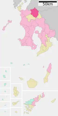
 Location of Isa in Kagoshima Prefecture | |
 Isa Location in Japan | |
| Coordinates: 32°3′26″N 130°36′47″E / 32.05722°N 130.61306°E | |
| Country | Japan |
| Region | Kyushu |
| Prefecture | Kagoshima Prefecture |
| Government | |
| • Mayor | Kinya Hashimoto (since November 2020) |
| Area | |
| • Total | 392.36 km2 (151.49 sq mi) |
| Population (October 1, 2010) | |
| • Total | 30,070 |
| • Density | 77/km2 (200/sq mi) |
| Time zone | UTC+09:00 (JST) |
| City hall address | Okuchi-sato 1888, Isa, Kagoshima (鹿児島県伊佐市大口里1888番地) 895-2511 |
| Climate | Cfa |
| Website | www |
| Symbols | |
| Flower | Cherry blossom |
| Tree | Chamaecyparis obtusa |
Isa (伊佐市, Isa-shi) is a city located in Kagoshima Prefecture, Japan.
The modern city of Isa was created on November 1, 2008, from the merger of the old city of Ōkuchi, and the town of Hishikari (from Isa District). Isa District was dissolved as a result of this merger.[1]
As of October 1, 2010, the city has an estimated population of 30,070, with 14,294 households and a population density of 76.64 persons per km². The total area is 392.36 km².
Geography
Climate
Isa has a humid subtropical climate (Köppen climate classification Cfa) with hot summers and mild winters. Precipitation is significant throughout the year, and is heavier in summer, especially the months of June and July. The average annual temperature in Isa is 15.6 °C (60.1 °F). The average annual rainfall is 2,799.8 mm (110.23 in) with June as the wettest month. The temperatures are highest on average in August, at around 26.3 °C (79.3 °F), and lowest in January, at around 4.6 °C (40.3 °F).[2] The city recorded −15.2 °C (4.6 °F) on January 25, 2016 which is the lowest temperature ever recorded of Lowlands in Kyushu, while the extreme maximum temperature was 37.6 °C (99.7 °F) on August 18, 2020.[3]
| Climate data for Ōkuchi, Isa (1991−2020 normals, extremes 1977−present) | |||||||||||||
|---|---|---|---|---|---|---|---|---|---|---|---|---|---|
| Month | Jan | Feb | Mar | Apr | May | Jun | Jul | Aug | Sep | Oct | Nov | Dec | Year |
| Record high °C (°F) | 22.1 (71.8) |
23.4 (74.1) |
26.3 (79.3) |
30.1 (86.2) |
34.0 (93.2) |
34.2 (93.6) |
37.2 (99.0) |
37.6 (99.7) |
36.4 (97.5) |
32.8 (91.0) |
28.2 (82.8) |
24.0 (75.2) |
37.6 (99.7) |
| Mean daily maximum °C (°F) | 10.6 (51.1) |
12.3 (54.1) |
15.9 (60.6) |
20.9 (69.6) |
25.3 (77.5) |
27.2 (81.0) |
31.1 (88.0) |
32.0 (89.6) |
29.4 (84.9) |
24.7 (76.5) |
18.9 (66.0) |
13.0 (55.4) |
21.8 (71.2) |
| Daily mean °C (°F) | 4.6 (40.3) |
6.0 (42.8) |
9.5 (49.1) |
14.2 (57.6) |
18.7 (65.7) |
22.2 (72.0) |
26.0 (78.8) |
26.3 (79.3) |
23.4 (74.1) |
17.8 (64.0) |
11.9 (53.4) |
6.4 (43.5) |
15.6 (60.1) |
| Mean daily minimum °C (°F) | −1.0 (30.2) |
0.1 (32.2) |
3.3 (37.9) |
7.7 (45.9) |
12.7 (54.9) |
18.2 (64.8) |
22.2 (72.0) |
22.4 (72.3) |
18.9 (66.0) |
12.1 (53.8) |
5.9 (42.6) |
0.7 (33.3) |
10.3 (50.5) |
| Record low °C (°F) | −15.2 (4.6) |
−10.2 (13.6) |
−7.7 (18.1) |
−4.2 (24.4) |
2.0 (35.6) |
6.8 (44.2) |
14.4 (57.9) |
15.2 (59.4) |
6.2 (43.2) |
−1.0 (30.2) |
−4.5 (23.9) |
−8.7 (16.3) |
−15.2 (4.6) |
| Average precipitation mm (inches) | 77.4 (3.05) |
123.0 (4.84) |
169.9 (6.69) |
200.7 (7.90) |
236.6 (9.31) |
625.8 (24.64) |
538.4 (21.20) |
275.0 (10.83) |
257.7 (10.15) |
101.0 (3.98) |
101.9 (4.01) |
92.4 (3.64) |
2,799.8 (110.23) |
| Average precipitation days (≥ 1.0 mm) | 8.6 | 9.6 | 12.2 | 10.9 | 10.4 | 16.7 | 14.7 | 13.3 | 11.4 | 7.4 | 8.7 | 8.7 | 132.6 |
| Mean monthly sunshine hours | 135.5 | 139.8 | 165.6 | 176.3 | 178.3 | 105.2 | 158.5 | 182.8 | 161.2 | 178.1 | 151.9 | 138.2 | 1,872.7 |
| Source: Japan Meteorological Agency[3][2] | |||||||||||||
Demographics
Per Japanese census data, the population of Isa in 2020 is 24,453 people.[4] Isa's population peaked in the 1950s and has been steadily declining since then until 2020.
|
|
References
- ↑ "市町村合併情報 鹿児島県 <国土地理協会>". Archived from the original on 2008-04-18. Retrieved 2008-09-13.
- 1 2 気象庁 / 平年値(年・月ごとの値). JMA. Retrieved March 26, 2022.
- 1 2 観測史上1~10位の値(年間を通じての値). JMA. Retrieved March 26, 2022.
- ↑ Isa population statistics
External links
- Isa City official website (in Japanese)
- Isa City merger (in Japanese)