Lamongan Regency
Kabupaten Lamongan | |
|---|---|
 Sunset at the village of Kandangsemangkon | |
 Coat of arms | |
| Motto(s): Memayu Raharjaning Praja (Persistent effort towards well-being of the people) | |
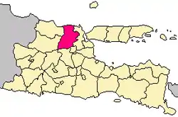 Location within East Java | |
| Coordinates: 7°07′S 112°25′E / 7.117°S 112.417°E | |
| Country | |
| Province | |
| Capital (city) | Lamongan City |
| Government | |
| • Regent | Dr.H.Yuhronur Efendi, M.B.A |
| • Vice Regent | Dra. Hj. Kartika Hidayati, M.M, MHP. |
| Area | |
| • Total | 1,812.80 km2 (699.93 sq mi) |
| Elevation | + 5 m (16 ft) |
| Population (mid 2022 estimate)[1] | |
| • Total | 1,386,941 |
| • Density | 770/km2 (2,000/sq mi) |
| Time zone | UTC+7 (IWST) |
| Area code | (+62) 322 |
| Website | lamongankab.go.id |

Lamongan Regency is a regency (kabupaten) of the East Java Province of Indonesia. It has a total land area of approximately 1,812.8 km2 (699.9 sq mi) or + 3.78% of the area of East Java Province. With a length of 47 km (29 mi) along the coastline (comprising Paciran and Brondong Districts), the sea area of Lamongan Regency is about 902.4 km2 (348.4 sq mi), if calculated to a distance of 12 miles (19 km) across the ocean surface. At the 2010 census it had a population of 1,179,059;[2] the 2020 Census produced a total of 1,379,628[3] and the official estimate as at mid-2022 was 1,386,941.[1] The regency seat is the town of Lamongan.
Lamongan Regency is bordered by:
- Northern side : Java Sea
- Southern side : Mojokerto Regency and Jombang Regency
- Eastern side : Gresik Regency
- Western side : Tuban Regency and Bojonegoro Regency
The economy is mainly supported by agriculture, fishery, and commerce, especially the home industry.
Administrative districts
Lamongan Regency consists of twenty-seven districts (kecamatan), tabulated below with their areas and population totals from the 2010 Census[2] and the 2020 Census,[3] together with the official estimates as of mid-2022.[1] The table also includes the locations of the district administrative centres, the number of administrative villages in each district (totaling 462 rural desa and 12 urban kelurahan), and their postal codes.
| Kode Wilayah | Name of District (kecamatan) | Area in km2 | Pop'n Census 2010 | Pop'n Census 2020 | Pop'n Estimate mid 2022 | Admin centre | No. of villages | Post codes |
|---|---|---|---|---|---|---|---|---|
| 35.24.01 | Sukorame | 41.47 | 20,126 | 21,671 | 21,402 | Sukorame | 9 | 62276 |
| 35.24.02 | Bluluk | 54.15 | 21,429 | 23,106 | 22,898 | Bluluk | 9 | 62274 |
| 35.24.04 | Ngimbang | 114.33 | 43,678 | 49,008 | 48,938 | Sendangrejo | 19 | 62273 |
| 35.24.11 | Sambeng | 195.44 | 47,998 | 52,727 | 52,455 | Ardirejo | 22 | 62284 |
| 35.24.16 | Mantup | 93.07 | 42,750 | 46,795 | 46,499 | Mantup | 15 | 62283 |
| 35.24.19 | Kembangbahu | 63.84 | 46,032 | 50,154 | 49,344 | Kembangbahu | 18 | 62282 |
| 35.24.12 | Sugio | 91.29 | 54,478 | 63,069 | 61,873 | Sugio | 21 | 62256 |
| 35.24.06 | Kedungpring | 84.43 | 50,313 | 62,642 | 63,201 | Kedungpring | 23 | 62272 |
| 35.24.03 | Modo | 77.80 | 44,988 | 51,386 | 51,197 | Mojorejo | 17 | 62275 |
| 35.24.05 | Babat | 62.95 | 76,178 | 92,301 | 93,241 | Bedahan | 23 (a) | 62271 |
| 35.24.13 | Pucuk | 44.84 | 39,053 | 49,785 | 50,553 | Pucuk | 17 | 62257 |
| 35.24.17 | Sukodadi | 52.32 | 50,682 | 57,823 | 57,480 | Sukodadi | 20 | 62253 |
| 35.24.22 | Lamongan (town) | 40.38 | 65,083 | 69,517 | 69,367 | Lamongan | 20 (b) | 62211 - 62218 |
| 35.24.23 | Tikung | 52.99 | 41,483 | 45,983 | 46,883 | Bakalanpule | 13 | 62280 |
| 35.24.27 | Sarirejo | 47.39 | 22,503 | 24,958 | 24,533 | Dermolemahbang | 9 | 62281` |
| 35.24.25 | Deket | 50.05 | 41,045 | 44,030 | 42,545 | Deketwetan | 17 | 62291 |
| 35.24.26 | Glagah | 40.52 | 35,014 | 41,539 | 41,443 | Glagah | 29 | 62292 |
| 35.24.24 | Karangbinangun | 52.88 | 33,285 | 40,445 | 40,418 | Sambopinggir | 21 | 62293 |
| 35.24.21 | Turi | 58.69 | 47,711 | 54,273 | 53,799 | Sukoanyar | 19 | 62252 |
| 35.24.20 | Kalitengah | 43.35 | 30,094 | 35,867 | 35,729 | Dibee | 20 | 62255 |
| 35.24.18 | Karanggeneng | 51.32 | 36,609 | 43,702 | 43,540 | Karanggeneng | 18 | 62254 |
| 35.24.09 | Sekaran | 49.65 | 33,443 | 48,091 | 49,768 | Bulutengger | 21 | 62260 |
| 35.24.10 | Maduran | 30.15 | 26,288 | 36,474 | 36,982 | Maduran | 17 | 62261 |
| 35.24.08 | Laren | 95.00 | 36,492 | 51,399 | 53,549 | Gampangsejati | 20 | 62262 |
| 35.24.15 | Solokuro | 101.02 | 39,530 | 48,057 | 50,047 | Payaman | 10 | 62265 |
| 35.24.14 | Paciran | 47.89 | 90,700 | 97,803 | 98,838 | Paciran | 17 (c) | 62264 |
| 35.24.07 | Brondong | 74.59 | 62,074 | 77,023 | 80,419 | Brondong | 10 (d) | 62263 |
| Totals | 1,812.80 | 1,179,059 | 1,379,628 | 1,386,941 | Lamongan | 474 |
Notes: (a) includes 2 kelurahan (Babat and Banaran). (b) comprises 8 kelurahan (Banjarmendalan, Jetis, Sidoharjo, Sidokumpul, Sukomulyo, Sukorejo, Tlogoanyar and Tumenggungan) and 12 desa.
(c) including one kelurahan (Blimbing). (d) including one kelurahan (Brondong).
Climate
Lamongan has a tropical savanna climate (Aw) with moderate to little rainfall from May to November and heavy rainfall from December to April. The following climate data is for the town of Lamongan.
| Climate data for Lamongan | |||||||||||||
|---|---|---|---|---|---|---|---|---|---|---|---|---|---|
| Month | Jan | Feb | Mar | Apr | May | Jun | Jul | Aug | Sep | Oct | Nov | Dec | Year |
| Mean daily maximum °C (°F) | 30.5 (86.9) |
30.5 (86.9) |
30.7 (87.3) |
31.4 (88.5) |
31.6 (88.9) |
31.5 (88.7) |
31.1 (88.0) |
31.9 (89.4) |
32.6 (90.7) |
33.2 (91.8) |
32.9 (91.2) |
31.3 (88.3) |
31.6 (88.9) |
| Daily mean °C (°F) | 26.9 (80.4) |
26.8 (80.2) |
26.9 (80.4) |
27.3 (81.1) |
27.3 (81.1) |
27.0 (80.6) |
26.4 (79.5) |
26.9 (80.4) |
27.5 (81.5) |
28.4 (83.1) |
28.3 (82.9) |
27.4 (81.3) |
27.3 (81.0) |
| Mean daily minimum °C (°F) | 23.4 (74.1) |
23.2 (73.8) |
23.2 (73.8) |
23.3 (73.9) |
23.1 (73.6) |
22.5 (72.5) |
21.8 (71.2) |
21.9 (71.4) |
22.4 (72.3) |
23.6 (74.5) |
23.8 (74.8) |
23.5 (74.3) |
23.0 (73.4) |
| Average rainfall mm (inches) | 280 (11.0) |
267 (10.5) |
272 (10.7) |
141 (5.6) |
107 (4.2) |
54 (2.1) |
33 (1.3) |
16 (0.6) |
13 (0.5) |
49 (1.9) |
118 (4.6) |
237 (9.3) |
1,587 (62.3) |
| Source: Climate-Data.org[4] | |||||||||||||
Paciran Port
On 29 April 2013, Paciran Port (Class I ASDP) was officially opened to support the overloaded Tanjung Perak Port.[5]
Sport
Persela is a football team based in Lamongan. Former Persela Lamongan goalkeeper Choirul Huda was from Lamongan.
References
- 1 2 3 Badan Pusat Statistik, Jakarta, 2023, Kabupaten Lamongan Dalam Angka 2023 (Katalog-BPS 1102001.3524)
- 1 2 Biro Pusat Statistik, Jakarta, 2011.
- 1 2 Badan Pusat Statistik, Jakarta, 2021.
- ↑ "Climate: Lamongan". Climate-Data.org. Retrieved 16 November 2020.
- ↑ "Hari Ini Menhub Resmikan Pelabuhan Paciran Lamongan". April 29, 2013. Archived from the original on June 6, 2013. Retrieved April 29, 2013.