Murat-sur-Vèbre | |
|---|---|
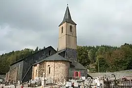 The church in Murat-sur-Vèbre | |
.svg.png.webp) Coat of arms | |
Location of Murat-sur-Vèbre | |
 Murat-sur-Vèbre  Murat-sur-Vèbre | |
| Coordinates: 43°41′10″N 2°51′16″E / 43.6861°N 2.8544°E | |
| Country | France |
| Region | Occitania |
| Department | Tarn |
| Arrondissement | Castres |
| Canton | Les Hautes Terres d'Oc |
| Intercommunality | Monts de Lacaune et Montagne du Haut Languedoc |
| Government | |
| • Mayor (2020–2026) | Daniel Vidal[1] |
| Area 1 | 98.80 km2 (38.15 sq mi) |
| Population | 871 |
| • Density | 8.8/km2 (23/sq mi) |
| Time zone | UTC+01:00 (CET) |
| • Summer (DST) | UTC+02:00 (CEST) |
| INSEE/Postal code | 81192 /81320 |
| Elevation | 543–1,205 m (1,781–3,953 ft) (avg. 750 m or 2,460 ft) |
| 1 French Land Register data, which excludes lakes, ponds, glaciers > 1 km2 (0.386 sq mi or 247 acres) and river estuaries. | |
Murat-sur-Vèbre (French pronunciation: [myʁa syʁ vɛbʁ]; Occitan: Murat) is a commune in the Tarn department and Occitanie region of southern France.
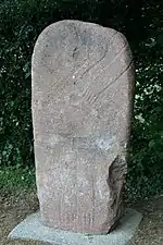
Statue menhir of Paillemalbiau

Statue menhir of Moulin de Louat
Geography
The Dourdou de Camarès River has its source in the commune.
See also
References
- ↑ "Répertoire national des élus: les maires" (in French). data.gouv.fr, Plateforme ouverte des données publiques françaises. 13 September 2022.
- ↑ "Populations légales 2021". The National Institute of Statistics and Economic Studies. 28 December 2023.
Wikimedia Commons has media related to Murat-sur-Vèbre.
This article is issued from Wikipedia. The text is licensed under Creative Commons - Attribution - Sharealike. Additional terms may apply for the media files.