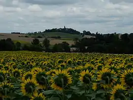
Teyssode | |
|---|---|
 Teyssode and its surroundings | |
.svg.png.webp) Coat of arms | |
Location of Teyssode | |
 Teyssode  Teyssode | |
| Coordinates: 43°39′02″N 1°56′08″E / 43.6506°N 1.9356°E | |
| Country | France |
| Region | Occitania |
| Department | Tarn |
| Arrondissement | Castres |
| Canton | Plaine de l'Agoût |
| Intercommunality | Lautrécois-Pays d'Agout |
| Government | |
| • Mayor (2020–2026) | Francis Moulet[1] |
| Area 1 | 22.88 km2 (8.83 sq mi) |
| Population | 381 |
| • Density | 17/km2 (43/sq mi) |
| Time zone | UTC+01:00 (CET) |
| • Summer (DST) | UTC+02:00 (CEST) |
| INSEE/Postal code | 81299 /81220 |
| Elevation | 127–327 m (417–1,073 ft) (avg. 288 m or 945 ft) |
| 1 French Land Register data, which excludes lakes, ponds, glaciers > 1 km2 (0.386 sq mi or 247 acres) and river estuaries. | |
Teyssode (French pronunciation: [tɛsɔd]; Languedocien: Teissòde) is a commune in the Tarn department in southern France.
Geography
Localisation
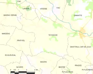
Teyssode is located south-east of Lavaur, the main town nearby.

Map of Teyssode
Neighbouring communes
Toponymy
The name of Teyssode is of gallo-romance origin, from the word taxo meaning badger.[3]
History
Teyssode is located on a former Roman oppidum.
In 1824, Teyssode absorbed the neighbouring commune of Saint-Germier.
See also
References
- ↑ "Répertoire national des élus: les maires". data.gouv.fr, Plateforme ouverte des données publiques françaises (in French). 9 August 2021.
- ↑ "Populations légales 2021". The National Institute of Statistics and Economic Studies. 28 December 2023.
- ↑ Teyssode Archived 2012-01-27 at the Wayback Machine on the website of the Intercommunality of the Pays d'Agout
External links
Wikimedia Commons has media related to Teyssode.
This article is issued from Wikipedia. The text is licensed under Creative Commons - Attribution - Sharealike. Additional terms may apply for the media files.