Olešná | |
|---|---|
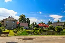 Pond and houses in the centre of Olešná | |
_Flag.jpg.webp) Flag _CoA.png.webp) Coat of arms | |
 Olešná Location in the Czech Republic | |
| Coordinates: 49°40′54″N 15°32′52″E / 49.68167°N 15.54778°E | |
| Country | |
| Region | Vysočina |
| District | Havlíčkův Brod |
| First mentioned | 1591 |
| Area | |
| • Total | 6.78 km2 (2.62 sq mi) |
| Elevation | 538 m (1,765 ft) |
| Population (2023-01-01)[1] | |
| • Total | 374 |
| • Density | 55/km2 (140/sq mi) |
| Time zone | UTC+1 (CET) |
| • Summer (DST) | UTC+2 (CEST) |
| Postal code | 580 01 |
| Website | www |
Olešná is a municipality and village in Havlíčkův Brod District in the Vysočina Region of the Czech Republic. It has about 400 inhabitants.
Olešná lies approximately 9 kilometres (6 mi) north of Havlíčkův Brod, 32 km (20 mi) north of Jihlava, and 93 km (58 mi) south-east of Prague.
References
Wikimedia Commons has media related to Olešná (Havlíčkův Brod District).
This article is issued from Wikipedia. The text is licensed under Creative Commons - Attribution - Sharealike. Additional terms may apply for the media files.