Pays-de-Belvès | |
|---|---|
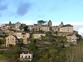 A general view of Belvès | |
Location of Pays-de-Belvès | |
 Pays-de-Belvès  Pays-de-Belvès | |
| Coordinates: 44°46′37″N 1°00′22″E / 44.777°N 1.006°E | |
| Country | France |
| Region | Nouvelle-Aquitaine |
| Department | Dordogne |
| Arrondissement | Sarlat-la-Canéda |
| Canton | Vallée Dordogne |
| Government | |
| • Mayor (2020–2026) | Christian Leothier[1] |
| Area 1 | 30.72 km2 (11.86 sq mi) |
| Population | 1,322 |
| • Density | 43/km2 (110/sq mi) |
| Time zone | UTC+01:00 (CET) |
| • Summer (DST) | UTC+02:00 (CEST) |
| INSEE/Postal code | 24035 /24170 |
| 1 French Land Register data, which excludes lakes, ponds, glaciers > 1 km2 (0.386 sq mi or 247 acres) and river estuaries. | |
Pays-de-Belvès (French pronunciation: [pe.i də bɛlvɛs], literally Land of Belvès; Occitan: País de Belvés) is a commune in the Dordogne department of southwestern France. The municipality was established on 1 January 2016 and consists of the former communes of Belvès and Saint-Amand-de-Belvès.[3] Belvès station has rail connections to Périgueux and Agen.
See also
References
Wikimedia Commons has media related to Pays de Belvès.
- ↑ "Répertoire national des élus: les maires" (in French). data.gouv.fr, Plateforme ouverte des données publiques françaises. 13 September 2022.
- ↑ "Populations légales 2021". The National Institute of Statistics and Economic Studies. 28 December 2023.
- ↑ Arrêté préfectoral 21 December 2015 (in French)
This article is issued from Wikipedia. The text is licensed under Creative Commons - Attribution - Sharealike. Additional terms may apply for the media files.