Powderhorn | |
|---|---|
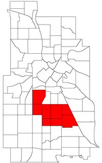 Location of Powderhorn within the U.S. city of Minneapolis | |
| Country | United States |
| State | Minnesota |
| County | Hennepin |
| City | Minneapolis |
| Neighborhoods | |
| Area | |
| • Total | 4.559 sq mi (11.81 km2) |
| Population (2020)[2] | |
| • Total | 55,913 |
| • Density | 12,000/sq mi (4,700/km2) |
| Time zone | UTC-6 (CST) |
| • Summer (DST) | UTC-5 (CDT) |
| ZIP code | 55404, 55405, 55406, 55407, 55408, 55409 |
| Area code | 612 |
| Census | Pop. | Note | %± |
|---|---|---|---|
| 1980 | 51,519 | — | |
| 1990 | 51,954 | 0.8% | |
| 2000 | 57,299 | 10.3% | |
| 2010 | 54,743 | −4.5% | |
| 2020 | 55,913 | 2.1% |
Powderhorn is a defined community in Minneapolis, that consists of eight neighborhoods.
Neighborhoods in the Powderhorn community
While most of Powderhorn is east of Interstate 35W and south of Lake Street, both the Lyndale and Whittier neighborhoods are west of I-35W, while Whittier is also north of Lake Street.
See also
References
- ↑ "Powderhorn neighborhood in Minneapolis, Minnesota (MN), 55404, 55406, 55407, 55408, 55409 detailed profile". City-Data. 2011. Retrieved 2013-11-12.
- ↑ "Powderhorn community data". Minnesota Compass. Retrieved 2023-04-02.
- ↑ Powderhorn, Minneapolis, MN. Google Earth. Retrieved 2011-03-09.
- Powderhorn, Minneapolis, MN. Google Earth. Retrieved 2011-03-09.
External links
This article is issued from Wikipedia. The text is licensed under Creative Commons - Attribution - Sharealike. Additional terms may apply for the media files.