Saint-Victor-et-Melvieu | |
|---|---|
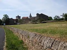
 A general view of Saint-Victor-et-Melvieu | |
.svg.png.webp) Coat of arms | |
Location of Saint-Victor-et-Melvieu | |
 Saint-Victor-et-Melvieu  Saint-Victor-et-Melvieu | |
| Coordinates: 44°03′07″N 2°49′58″E / 44.0519°N 2.8328°E | |
| Country | France |
| Region | Occitania |
| Department | Aveyron |
| Arrondissement | Millau |
| Canton | Raspes et Lévezou |
| Government | |
| • Mayor (2020–2026) | Jean Capel[1] |
| Area 1 | 17.91 km2 (6.92 sq mi) |
| Population | 315 |
| • Density | 18/km2 (46/sq mi) |
| Time zone | UTC+01:00 (CET) |
| • Summer (DST) | UTC+02:00 (CEST) |
| INSEE/Postal code | 12251 /12400 |
| Elevation | 262–689 m (860–2,260 ft) (avg. 632 m or 2,073 ft) |
| 1 French Land Register data, which excludes lakes, ponds, glaciers > 1 km2 (0.386 sq mi or 247 acres) and river estuaries. | |
Saint-Victor-et-Melvieu (French pronunciation: [sɛ̃ viktɔʁ e mɛlvjø]; Languedocien: Sant Victor e Malviu) is a commune in the Aveyron department in southern France.
Geography
.jpg.webp)
Generalities
In the south of the Massif Central, in the southern half of the department of Aveyron, the commune of Saint-Victor-et-Melvieu is situated in the interior of natural regional park of the Grands Causses. The communal territory, which extends for 17.91 km^2, is constituted of landscapes of avant-causses, characterized by hills. It is bordered on the north and northwest by the Tarn in the gorges called the Raspes, where the hydroelectric dams of Pinet and of Truel (or Pouget) are implanted.
The minimal altitude, with 262 meters, is localized at the extreme west, near the place called the May d'Entraygues, where the Tarn leaves the commune and enters that of Le Truel. The maximal altitude with 689 or 694 meters[note 1] is a kilometer and a half to the northwest of the village of Saint-Victor, at the Puech de Luargues.[3]
Hydrography
Hydrographic network

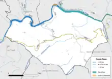
The commune is drained by the Tarn, the stream of Geneve, the stream of the Valade, a branch of the Tarn, the stream of Pourquairol, the stream of Ricardel, and by several small courses of water.[4]
The Lac de Pinet completes the hydrographic network. It is related to a very wild lake on its part downstream, of a maximum depth of 25 meters and a superficial one of 130 ha. It is open to fishing at the upstream part up to Mas de Lanauq. It is in the territories and communes of Saint-Rome-de-Tarn, Saint-Victor-et-Melvieu, and Viala-du-Tarn.[5]
Management of courses of water
Administration of courses of water in the Aveyron basin is assured by the public establishment of management and administration of water Aveyron upstream, created on 1 January 2017, replacing the mixed syndicate of basin slope Aveyron upstream.[6][7]
Population
| Year | Pop. | ±% |
|---|---|---|
| 1962 | 278 | — |
| 1968 | 367 | +32.0% |
| 1975 | 296 | −19.3% |
| 1982 | 305 | +3.0% |
| 1990 | 299 | −2.0% |
| 1999 | 329 | +10.0% |
| 2008 | 374 | +13.7% |
See also
Notes
- ↑ Two different values for the IGN, 694 meters on the chart and 689 on its ancient site.
References
- ↑ "Répertoire national des élus: les maires". data.gouv.fr, Plateforme ouverte des données publiques françaises (in French). 9 August 2021.
- ↑ "Populations légales 2021". The National Institute of Statistics and Economic Studies. 28 December 2023.
- ↑ "Géoportail". www.geoportail.gouv.fr. Retrieved 20 July 2021.
- ↑ "Fiche Ma Commune - SIGES Occitanie - ©2021". sigesocc.brgm.fr. Retrieved 20 July 2021.
- ↑ "Lac de Pinet, Viala-du-Tarn". Tourisme Aveyron (in French). Retrieved 20 July 2021.
- ↑ "BANATIC, la base nationale sur l'intercommunalité". www.banatic.interieur.gouv.fr. Retrieved 20 July 2021.
- ↑ "Aveyron amont | Gest'eau". www.gesteau.fr. Retrieved 20 July 2021.