Sainte-Eulalie-de-Cernon | |
|---|---|
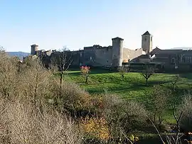 The fortified hospital | |
.svg.png.webp) Coat of arms | |
Location of Sainte-Eulalie-de-Cernon | |
 Sainte-Eulalie-de-Cernon  Sainte-Eulalie-de-Cernon | |
| Coordinates: 43°58′57″N 3°08′13″E / 43.9825°N 3.1369°E | |
| Country | France |
| Region | Occitania |
| Department | Aveyron |
| Arrondissement | Millau |
| Canton | Causses-Rougiers |
| Intercommunality | Larzac et Vallées |
| Government | |
| • Mayor (2020–2026) | Thierry Cadenet[1] |
| Area 1 | 46.35 km2 (17.90 sq mi) |
| Population | 310 |
| • Density | 6.7/km2 (17/sq mi) |
| Time zone | UTC+01:00 (CET) |
| • Summer (DST) | UTC+02:00 (CEST) |
| INSEE/Postal code | 12220 /12230 |
| Elevation | 529–912 m (1,736–2,992 ft) (avg. 635 m or 2,083 ft) |
| 1 French Land Register data, which excludes lakes, ponds, glaciers > 1 km2 (0.386 sq mi or 247 acres) and river estuaries. | |
Sainte-Eulalie-de-Cernon (French pronunciation: [sɛ̃.t‿ølali də sɛʁnɔ̃]; Occitan: Senta Aulària de Sarnon) is a commune in the southern French department of Aveyron.
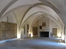
At the heart of the historic settlement is the Commandery of Saint Eulalia, a hospital (in the medieval sense of the word) established by the Order of the Knights Templar. After that Order was disbanded by Philip IV of France in 1307-08, royal forces were sent to close the hospital down, and from that event a detailed account of the buildings, their contents, both in the chapel and in the secular parts of the complex, and the life and customs of the occupants, has survived.[3]

The Commandery came under the control of the Knights Hospitallers during the Hundred Years War and survived until its final destruction as a result of the French Revolution towards the end of the eighteenth century.[3]
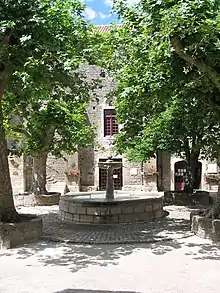
Many medieval buildings survive, together with later ones, inside high defensive walls.
Population
| Year | Pop. | ±% |
|---|---|---|
| 1962 | 220 | — |
| 1968 | 248 | +12.7% |
| 1975 | 253 | +2.0% |
| 1982 | 230 | −9.1% |
| 1990 | 219 | −4.8% |
| 1999 | 221 | +0.9% |
| 2008 | 248 | +12.2% |
See also
Notes and references
- ↑ "Répertoire national des élus: les maires" (in French). data.gouv.fr, Plateforme ouverte des données publiques françaises. 13 September 2022.
- ↑ "Populations légales 2021". The National Institute of Statistics and Economic Studies. 28 December 2023.
- 1 2 Dominic Selwood, Knights of the Cloister (Boydell Press paperback, 2001), Chapter VII pp 197–207