Salles-Curan | |
|---|---|
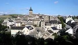 A general view of Salles-Curan | |
.svg.png.webp) Coat of arms | |
Location of Salles-Curan | |
 Salles-Curan  Salles-Curan | |
| Coordinates: 44°11′00″N 2°47′16″E / 44.1833°N 2.7878°E | |
| Country | France |
| Region | Occitania |
| Department | Aveyron |
| Arrondissement | Millau |
| Canton | Raspes et Lévezou |
| Intercommunality | Lévézou Pareloup |
| Government | |
| • Mayor (2020–2026) | Maurice Combettes[1] |
| Area 1 | 93.9 km2 (36.3 sq mi) |
| Population | 1,017 |
| • Density | 11/km2 (28/sq mi) |
| Time zone | UTC+01:00 (CET) |
| • Summer (DST) | UTC+02:00 (CEST) |
| INSEE/Postal code | 12253 /12410 |
| Elevation | 547–1,084 m (1,795–3,556 ft) (avg. 820 m or 2,690 ft) |
| 1 French Land Register data, which excludes lakes, ponds, glaciers > 1 km2 (0.386 sq mi or 247 acres) and river estuaries. | |
Salles-Curan (French pronunciation: [sal kyʁɑ̃]; Occitan: Las Salas) is a commune in the Aveyron department in southern France.
Geography
The lac de Pareloup forms part of the commune's northern border.
The river Céor has its source in the western part of the commune.
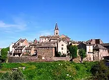
View of Salles-Curan
Population
| Year | Pop. | ±% |
|---|---|---|
| 1962 | 1,443 | — |
| 1968 | 1,538 | +6.6% |
| 1975 | 1,491 | −3.1% |
| 1982 | 1,419 | −4.8% |
| 1990 | 1,277 | −10.0% |
| 1999 | 1,088 | −14.8% |
| 2008 | 1,064 | −2.2% |
See also
References
- ↑ "Répertoire national des élus: les maires". data.gouv.fr, Plateforme ouverte des données publiques françaises (in French). 9 August 2021.
- ↑ "Populations légales 2021". The National Institute of Statistics and Economic Studies. 28 December 2023.
Wikimedia Commons has media related to Salles-Curan.
This article is issued from Wikipedia. The text is licensed under Creative Commons - Attribution - Sharealike. Additional terms may apply for the media files.