Saramacca Polder | |
|---|---|
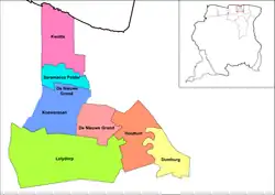
 Map showing the resorts of Wanica District. Saramacca Polder | |
| Country | |
| District | Wanica District |
| Area | |
| • Total | 28 km2 (11 sq mi) |
| Population (2012)[1] | |
| • Total | 10,217 |
| • Density | 360/km2 (950/sq mi) |
| Time zone | UTC-3 (AST) |
Saramacca Polder is a resort in Suriname, located in the Wanica District. Its population at the 2012 census was 10,217. And the majority of the population is of East Indian descent.[1] The Saramacca Polder was created between 1894 and 1904. The main function was agriculture.[2] The Commissaris Weytinghweg was built in 1906, and connects the polder with Paramaribo. Initially the area was mainly used for rice cultivation, but has become home to companies and suburban housing.[3]
Notable people
- Marijke Djwalapersad (1951), politician and former Chairperson of the National Assembly[4]
References
- 1 2 "Resorts in Suriname Census 2012" (PDF). Retrieved 27 May 2020.
- ↑ "Encyclopaedie van Nederlandsch West-Indië - Page 509 - Nickerie" (PDF). Digital Library for Dutch Literature (in Dutch). 1916. Retrieved 11 May 2020.
- ↑ "Distrikt Wanica 2". Suriname.nu (in Dutch). Retrieved 27 May 2020.
- ↑ "Sranan uma: Drop-out-opvangster en baanbrekende politica". De Ware Tijd (in Dutch). Retrieved 16 May 2021.
5°49′44″N 55°15′14″W / 5.828889°N 55.253889°W
This article is issued from Wikipedia. The text is licensed under Creative Commons - Attribution - Sharealike. Additional terms may apply for the media files.
