Kwakoegron | |
|---|---|
Resort | |
 Former train station of Kwakoegron (1947) | |
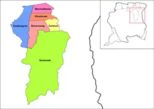
 Map showing the resorts of Brokopondo District. Kwakoegron | |
| Coordinates: 5°14′53″N 55°20′41″W / 5.24806°N 55.34472°W | |
| Country | |
| District | Brokopondo |
| Area | |
| • Total | 1,050 km2 (410 sq mi) |
| Population (1 January 2012)[1] | |
| • Total | 263 |
| • Density | 0.25/km2 (0.65/sq mi) |
| Time zone | UTC-3 (AST) |
Kwakoegron (land of Kwakoe) is a town and resort in Suriname. It is located inland, due south of Paramaribo. According to the 2012 census it has a population of 263, and is mainly inhabited by Maroons,[1] of the Matawai people.[2] The resort and town are named after Kwakoe, the native word for Wednesday, and grond, the Dutch word for ground.[3] The captain of the resort resides in the village Commisariskondre.[2]
Overview
Kwakoegron has a school, a clinic, and a holiday resort.[2] The resort can be accessed via a paved side road of the Southern East-West Link[4] In 1910, Kwakoegron was connected to the Lawa Railway which closed in 1987.[5]
The Brinckheuvel Nature Reserve is located near the village.[6]
See also
References
- 1 2 "Resorts in Suriname Census 2012" (PDF). Retrieved 21 May 2020.
- 1 2 3 "Structuur Analyse" (PDF). Planning Office Suriname (in Dutch). Retrieved 25 May 2020.
- ↑ "Encyclopaedie van Nederlandsch West-Indië - Page 448 - Lelydorp" (PDF). Digital Library for Dutch Literature (in Dutch). 1916. Retrieved 5 May 2020.
- ↑ "Asfaltering wegstrekking Pikin Saron – Kwakoegron afgerond". GFC Nieuws (in Dutch). Retrieved 21 May 2020.
- ↑ "De flop van Lely". Parbode (in Dutch). 2 April 2008. Retrieved 13 May 2020.
- ↑ Ouboter, Paul E. (2001). "Directory of protected areas of Suriname". IBER. p. 71.
External links
Wikimedia Commons has media related to Kwakoegron.
This article is issued from Wikipedia. The text is licensed under Creative Commons - Attribution - Sharealike. Additional terms may apply for the media files.
