Segovia, Antioquia | |
|---|---|
Municipality and town | |
.svg.png.webp) Flag .svg.png.webp) Seal | |
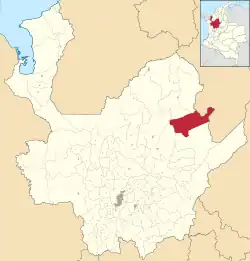 Location of the municipality and town of Segovia, Antioquia in the Antioquia Department of Colombia | |
 Segovia, Antioquia Location in Colombia | |
| Coordinates: 7°4′41″N 74°42′6″W / 7.07806°N 74.70167°W | |
| Country | |
| Department | |
| Subregion | Northeastern |
| Area | |
| • Municipality and town | 1,127 km2 (435 sq mi) |
| • Urban | 3.82 km2 (1.47 sq mi) |
| Elevation | 650 m (2,130 ft) |
| Population (2018 census)[1] | |
| • Municipality and town | 37,900 |
| • Density | 34/km2 (87/sq mi) |
| • Urban | 30,133 |
| • Urban density | 7,900/km2 (20,000/sq mi) |
| Time zone | UTC-5 (Colombia Standard Time) |
Segovia (Spanish pronunciation: [seˈɣoβja] ⓘ) is a town and municipality in Antioquia Department, Colombia. Part of the subregion of Northeastern Antioquia, its elevation is 650 m (2,130 ft) above sea level. There are gold mines in the area.
Capital: Medellín | |||||||||||||||||||
| Regions and municipalities |
| ||||||||||||||||||
| Related topics | |||||||||||||||||||
| Gold |
|  |
|---|---|---|
| Silver | ||
| Platinum | ||
| Nickel |
| |
| Coltan | ||
| Emeralds | ||
| Coal | ||
| Salt | ||
| Sources | ||
References
- ↑ Citypopulation.de Population of Segovia municipality with localities
This article is issued from Wikipedia. The text is licensed under Creative Commons - Attribution - Sharealike. Additional terms may apply for the media files.