Stříbrné Hory | |
|---|---|
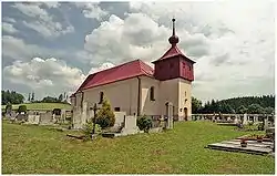 Church of Saint Catherine | |
_vlajka.jpg.webp) Flag _znak.jpg.webp) Coat of arms | |
 Stříbrné Hory Location in the Czech Republic | |
| Coordinates: 49°36′5″N 15°41′28″E / 49.60139°N 15.69111°E | |
| Country | |
| Region | Vysočina |
| District | Havlíčkův Brod |
| First mentioned | 1654 |
| Area | |
| • Total | 3.75 km2 (1.45 sq mi) |
| Elevation | 473 m (1,552 ft) |
| Population (2023-01-01)[1] | |
| • Total | 243 |
| • Density | 65/km2 (170/sq mi) |
| Time zone | UTC+1 (CET) |
| • Summer (DST) | UTC+2 (CEST) |
| Postal code | 582 22 |
| Website | www |
Stříbrné Hory (until 1947 Český Šicndorf; German: Böhmisch Schützendorf) is a municipality and village in Havlíčkův Brod District in the Vysočina Region of the Czech Republic. It has about 200 inhabitants.
Stříbrné Hory lies approximately 9 kilometres (6 mi) east of Havlíčkův Brod, 25 km (16 mi) north of Jihlava, and 106 km (66 mi) south-east of Prague.
References
Wikimedia Commons has media related to Stříbrné Hory.
This article is issued from Wikipedia. The text is licensed under Creative Commons - Attribution - Sharealike. Additional terms may apply for the media files.