Větrušice | |
|---|---|
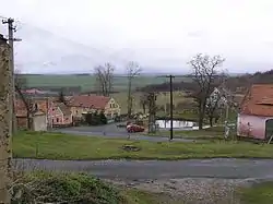 Centre of Větrušice | |
 Flag  Coat of arms | |
 Větrušice Location in the Czech Republic | |
| Coordinates: 50°11′27″N 14°23′0″E / 50.19083°N 14.38333°E | |
| Country | |
| Region | Central Bohemian |
| District | Prague-East |
| First mentioned | 1316 |
| Area | |
| • Total | 2.86 km2 (1.10 sq mi) |
| Elevation | 261 m (856 ft) |
| Population (2023-01-01)[1] | |
| • Total | 706 |
| • Density | 250/km2 (640/sq mi) |
| Time zone | UTC+1 (CET) |
| • Summer (DST) | UTC+2 (CEST) |
| Postal code | 250 67 |
| Website | www |
Větrušice is a municipality and village in Prague-East District in the Central Bohemian Region of the Czech Republic. It has about 700 inhabitants.
Geography
Větrušice is located on the right bank of the Vltava River, about 7 kilometres (4 mi) north of Prague. Along the Vltava there is the Větrušická rokle National Nature Reserve. It is a large complex of steep rocks, rocky ridges, gorges and wooded slopes, where there are diverse communities of dry grasslands and rocky steppes.[2]
References
- ↑ "Population of Municipalities – 1 January 2023". Czech Statistical Office. 2023-05-23.
- ↑ "Národní přírodní rezervace Větrušické rokle" (in Czech). CzechTourism. Retrieved 2022-05-04.
Wikimedia Commons has media related to Větrušice.
This article is issued from Wikipedia. The text is licensed under Creative Commons - Attribution - Sharealike. Additional terms may apply for the media files.