Accons | |
|---|---|
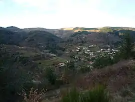
 A view towards Mariac from Accons | |
Location of Accons | |
 Accons  Accons | |
| Coordinates: 44°53′14″N 4°23′16″E / 44.8872°N 4.3878°E | |
| Country | France |
| Region | Auvergne-Rhône-Alpes |
| Department | Ardèche |
| Arrondissement | Tournon-sur-Rhône |
| Canton | Haut-Eyrieux |
| Intercommunality | Val'Eyrieux |
| Government | |
| • Mayor (2020–2026) | Josette Clauzier[1] |
| Area 1 | 9.87 km2 (3.81 sq mi) |
| Population | 369 |
| • Density | 37/km2 (97/sq mi) |
| Time zone | UTC+01:00 (CET) |
| • Summer (DST) | UTC+02:00 (CEST) |
| INSEE/Postal code | 07001 /07160 |
| Elevation | 476–1,201 m (1,562–3,940 ft) (avg. 560 m or 1,840 ft) |
| 1 French Land Register data, which excludes lakes, ponds, glaciers > 1 km2 (0.386 sq mi or 247 acres) and river estuaries. | |
Accons is a commune in the Ardèche department in the Auvergne-Rhône-Alpes region of southern France. The inhabitants are called Acconnais or Acconnaises.[3]
Geography
Accons is located in the arrondissement of Tournon-sur-Rhone and the canton of Haut-Eyrieux, 4 km south-west of Le Cheylard and some 50 km south-east of Le Puy-en-Velay. The only road into Accons is the D578 running west from Le Cheylard and continuing to Mariac. Accons village is accessed by the Accons road or La Mothe road which both branch off the D578. In the north of the commune is the hamlet of Villebrion which is also accessed by small mountain roads.[4]
The Dorne river crosses the commune from west to east north of the village as it flows east to join the Eyrieux at Le Cheylard. Many tributaries feed the Dorne from the commune: in the north the Ruisseau des Combes forms the western border as it flows south to join the Dorne; in the south many streams flow north to join the Dorne including the Ruisseau de Praderne which forms part of the western border before joining the Dorne and the Ruisseau de Boure flows north through the centre of the commune.[4]
Neighbouring Communes
Administration
List of Successive Mayors of Accons[5]
| From | To | Name |
|---|---|---|
| 2001 | 2014 | Bernadette Pinet-Cuoq |
| 2014 | Current | Josette Clauzier |
Population
|
| ||||||||||||||||||||||||||||||||||||||||||||||||||||||||||||||||||||||||||||||||||||||||||||||||||||||||||||||||||
| Source: EHESS[6] and INSEE[7] | |||||||||||||||||||||||||||||||||||||||||||||||||||||||||||||||||||||||||||||||||||||||||||||||||||||||||||||||||||
Sites and Monuments
- The Château de la Mothe: a 15th to 16th century church with an attractive bell tower.
See also
References
- ↑ "Répertoire national des élus: les maires". data.gouv.fr, Plateforme ouverte des données publiques françaises (in French). 2 December 2020.
- ↑ "Populations légales 2021". The National Institute of Statistics and Economic Studies. 28 December 2023.
- ↑ Inhabitants of France website
- 1 2 3 Google Maps
- ↑ List of Mayors of France (in French)
- ↑ Des villages de Cassini aux communes d'aujourd'hui: Commune data sheet Accons, EHESS (in French).
- ↑ Population en historique depuis 1968, INSEE
External links
- Accons official website (in French)
- Accons on the old IGN website (in French)
- Accons on Géoportail, National Geographic Institute (IGN) website (in French)
- Accons on the 1750 Cassini Map