Asakura
朝倉市 | |
|---|---|
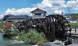
 Asakura Three Waterwheels | |
 Flag  Emblem | |
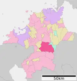
 Location of Asakura in Fukuoka Prefecture | |
 Asakura Location in Japan | |
| Coordinates: 33°25′N 130°40′E / 33.417°N 130.667°E | |
| Country | Japan |
| Region | Kyushu |
| Prefecture | Fukuoka Prefecture |
| Government | |
| • Mayor | Susuke Morita (since April 2010) |
| Area | |
| • Total | 246.73 km2 (95.26 sq mi) |
| Population (January 31, 2011) | |
| • Total | 57,488 |
| • Density | 233.00/km2 (603.5/sq mi) |
| Time zone | UTC+09:00 (JST) |
| City hall address | 412-2 Bodaiji, Asakura-shi, Fukuoka-ken 838-0061 |
| Climate | Cfa |
| Website | www |
Asakura (朝倉市, Asakura-shi) is a city located in south central Fukuoka Prefecture, Japan, on Kyūshū Island.
The modern city of Asakura was established on March 20, 2006, from the merger of the former town of Asakura (from Asakura District), absorbing the city of Amagi, and the town of Haki (also from Asakura District).
As of January 31, 2011, the city has an estimated population of 57,488 and a population density of 233 persons per km2. The total area is 246.73 km2.
Geography
Asakura is located about 40 km southeast of Fukuoka and about 20 km northeast of Kurume.
Climate
Asakura has a humid subtropical climate (Köppen: Cfa). The average annual temperature in Asakura is 15.9 °C (60.6 °F). The average annual rainfall is 1,953.0 mm (76.89 in) with July as the wettest month. The temperatures are highest on average in August, at around 27.4 °C (81.3 °F), and lowest in January, at around 4.7 °C (40.5 °F).[1] The highest temperature ever recorded in Asakura was 38.8 °C (101.8 °F) on 16 July 1994; the coldest temperature ever recorded was −8.3 °C (17.1 °F) on 25 January 2016.[2]
| Climate data for Asakura (1991−2020 normals, extremes 1977−present) | |||||||||||||
|---|---|---|---|---|---|---|---|---|---|---|---|---|---|
| Month | Jan | Feb | Mar | Apr | May | Jun | Jul | Aug | Sep | Oct | Nov | Dec | Year |
| Record high °C (°F) | 19.8 (67.6) |
24.7 (76.5) |
26.1 (79.0) |
31.4 (88.5) |
35.1 (95.2) |
37.6 (99.7) |
38.8 (101.8) |
38.4 (101.1) |
37.1 (98.8) |
32.8 (91.0) |
26.8 (80.2) |
24.2 (75.6) |
38.8 (101.8) |
| Mean daily maximum °C (°F) | 9.8 (49.6) |
11.5 (52.7) |
15.3 (59.5) |
20.9 (69.6) |
25.8 (78.4) |
28.2 (82.8) |
31.8 (89.2) |
33.2 (91.8) |
29.4 (84.9) |
24.2 (75.6) |
18.1 (64.6) |
12.1 (53.8) |
21.7 (71.0) |
| Daily mean °C (°F) | 4.7 (40.5) |
6.0 (42.8) |
9.4 (48.9) |
14.4 (57.9) |
19.2 (66.6) |
22.9 (73.2) |
26.8 (80.2) |
27.4 (81.3) |
23.6 (74.5) |
17.9 (64.2) |
12.1 (53.8) |
6.7 (44.1) |
15.9 (60.7) |
| Mean daily minimum °C (°F) | 0.3 (32.5) |
0.9 (33.6) |
3.9 (39.0) |
8.4 (47.1) |
13.4 (56.1) |
18.6 (65.5) |
23.0 (73.4) |
23.3 (73.9) |
19.3 (66.7) |
12.8 (55.0) |
6.9 (44.4) |
2.0 (35.6) |
11.1 (51.9) |
| Record low °C (°F) | −8.3 (17.1) |
−7.5 (18.5) |
−5.6 (21.9) |
−1.6 (29.1) |
3.2 (37.8) |
8.6 (47.5) |
14.1 (57.4) |
15.1 (59.2) |
6.2 (43.2) |
0.7 (33.3) |
−2.0 (28.4) |
−5.7 (21.7) |
−8.3 (17.1) |
| Average precipitation mm (inches) | 64.6 (2.54) |
81.4 (3.20) |
121.8 (4.80) |
139.2 (5.48) |
169.5 (6.67) |
333.6 (13.13) |
413.2 (16.27) |
206.9 (8.15) |
176.6 (6.95) |
92.4 (3.64) |
88.9 (3.50) |
65.0 (2.56) |
1,953 (76.89) |
| Average precipitation days (≥ 1.0 mm) | 9.0 | 9.1 | 10.9 | 10.1 | 9.0 | 13.3 | 12.9 | 10.6 | 9.5 | 7.0 | 8.5 | 8.6 | 118.5 |
| Mean monthly sunshine hours | 112.5 | 129.7 | 162.3 | 181.5 | 194.6 | 122.6 | 164.1 | 194.7 | 159.6 | 175.3 | 139.1 | 118.9 | 1,854.9 |
| Source: Japan Meteorological Agency[1][2] | |||||||||||||
Adjoining municipalities
Demographics
Per Japanese census data, the population of Asakura in 2020 is 50,273 people.[3] Asakura has been conducting censuses since 1920.
| Year | Pop. | ±% |
|---|---|---|
| 1920 | 56,148 | — |
| 1925 | 60,124 | +7.1% |
| 1930 | 62,723 | +4.3% |
| 1935 | 61,961 | −1.2% |
| 1940 | 61,683 | −0.4% |
| 1945 | 77,102 | +25.0% |
| 1950 | 76,815 | −0.4% |
| 1955 | 76,687 | −0.2% |
| 1960 | 72,592 | −5.3% |
| 1965 | 68,575 | −5.5% |
| 1970 | 66,623 | −2.8% |
| 1975 | 64,982 | −2.5% |
| 1980 | 64,623 | −0.6% |
| 1985 | 65,128 | +0.8% |
| 1990 | 63,724 | −2.2% |
| 1995 | 62,593 | −1.8% |
| 2000 | 61,707 | −1.4% |
| 2005 | 59,385 | −3.8% |
| 2010 | 56,366 | −5.1% |
| 2015 | 52,444 | −7.0% |
| 2020 | 50,273 | −4.1% |
| Asakura population statistics[3] | ||
History
The imperial court moved to the Tachibana no Hironiwa Palace, where it stayed from May until July 661.
- October, 1876 - Outbreak of the Akizuki Rebellion
- April 1, 1889 - The modern municipal system is established. The current city region is occupied by one town, Amagi; and 18 villages: Akizuki, Asakura, Haki, Hinashiro, Fukuda, Fukunari, Kamiakizuki, Kanagawa, Takagi, Kugumiya, Mada, Masue, Minagi, Miyano, Ōba, Shiwa, Tateishi and Yasukawa.
- December 27, 1893 - Akizuki was elevated to town status.
- June 15, 1909 - Fukunari and Ōba were merged to create Daifuku Village.
- April 17, 1939 - Haki was elevated to town status.
- April 1, 1951 - Kugumiya, Masue and Shiwa were merged into Haki Town.
- April 1, 1954 - Amagi, Akizuki, Fukuda, Hinashiro, Kamiakizuki, Kanagawa, Mada, Minagi, Tateishi and Yasukawa were all merged to create Amagi City.
- March 10, 1955 - Takagi was merged into Amagi City.
- March 31, 1955 - Daifuku and Miyano were merged into Asakura Village.
- April 1, 1962 - Asakura was elevated to town status.
- March 20, 2006 - Amagi, Asakura and Haki were merged to create Asakura City.
Education
Prefectural senior high schools
- Asakura Kōyō Senior High School
- Asakura Higashi Senior High School
- Asakura Senior High School
Municipal junior high schools
- Amagi Junior High School
- Akizuki Junior High School
- Haki Junior High School
- Hiramatsu Junior High School
- Jūmonji Junior High School
- Nanryō Junior High School
Municipal elementary schools
- Amagi Elementary School
- Asakura Higashi Elementary School
- Akizuki Elementary School
- Daifuku Elementary School
- Fukuda Elementary School
- Haki Elementary School
- Hinashiro Elementary School
- Kanagawa Elementary School
- Kugumiya Elementary School
- Mada Elementary School
- Masue Elementary School
- Minagi Elementary School
- Shiwa Elementary School
- Tateishi Elementary School
Transportation
Air
The closest airport is Fukuoka Airport.
Rail
Road
- Expressways
- Ōita Expressway
- Amagi Interchange - Asakura Interchange - Yamada Service Area - Haki Interchange
- Ōita Expressway
- National highways:
- Route 322
- Route 386
- Harazuru Roadside Station
- Route 500
- Main prefectural roads:
- Mada-Tonta Route 8
- Tosu-Asakura Route 14
- Amagi-Tanushimaru Route 33
- Yame-Kawara Route 52
- Keisenshimo-Akizuki Route 66
- Asakura-Koishiwara Route 79
- Amagi-Asakura-Tanushimaru Route 80
Scenic and historic places

Festivals and events
- Dorouchi Festival
- Oshiroi Festival
Notable people
- Michiko Kichise – actress and model
References
- 1 2 気象庁 / 平年値(年・月ごとの値). JMA. Retrieved May 23, 2022.
- 1 2 観測史上1~10位の値(年間を通じての値). JMA. Retrieved May 23, 2022.
- 1 2 Asakura population statistics
External links
 Media related to Asakura, Fukuoka at Wikimedia Commons
- Asakura City official website (in Japanese)