Autrey | |
|---|---|
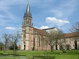 The abbey and gardens in Autrey | |
Location of Autrey | |
 Autrey  Autrey | |
| Coordinates: 48°17′50″N 6°41′24″E / 48.2972°N 6.69°E | |
| Country | France |
| Region | Grand Est |
| Department | Vosges |
| Arrondissement | Épinal |
| Canton | Saint-Dié-des-Vosges-1 |
| Intercommunality | CC Région Rambervillers |
| Government | |
| • Mayor (2020–2026) | Jacques Colne[1] |
| Area 1 | 17.42 km2 (6.73 sq mi) |
| Population | 277 |
| • Density | 16/km2 (41/sq mi) |
| Time zone | UTC+01:00 (CET) |
| • Summer (DST) | UTC+02:00 (CEST) |
| INSEE/Postal code | 88021 /88700 |
| Elevation | 306–535 m (1,004–1,755 ft) (avg. 320 m or 1,050 ft) |
| 1 French Land Register data, which excludes lakes, ponds, glaciers > 1 km2 (0.386 sq mi or 247 acres) and river estuaries. | |
Autrey (French pronunciation: [otʁɛ] ⓘ) is a commune in the Vosges department in Grand Est in northeastern France.
Geography
The village lies in the north-western part of the commune, on the right bank of the Mortagne, which forms all of the commune's western and south-western borders.
Points of interest
See also
References
- ↑ "Répertoire national des élus: les maires". data.gouv.fr, Plateforme ouverte des données publiques françaises (in French). 9 August 2021.
- ↑ "Populations légales 2021". The National Institute of Statistics and Economic Studies. 28 December 2023.
Wikimedia Commons has media related to Autrey (Vosges).
This article is issued from Wikipedia. The text is licensed under Creative Commons - Attribution - Sharealike. Additional terms may apply for the media files.