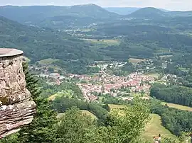
La Petite-Raon | |
|---|---|
 A general view of La Petite-Raon | |
 Coat of arms | |
Location of La Petite-Raon | |
 La Petite-Raon  La Petite-Raon | |
| Coordinates: 48°24′26″N 6°59′44″E / 48.4072°N 6.9956°E | |
| Country | France |
| Region | Grand Est |
| Department | Vosges |
| Arrondissement | Saint-Dié-des-Vosges |
| Canton | Raon-l'Étape |
| Intercommunality | CA Saint-Dié-des-Vosges |
| Government | |
| • Mayor (2020–2026) | Jean Rabolt[1] |
| Area 1 | 9.09 km2 (3.51 sq mi) |
| Population | 739 |
| • Density | 81/km2 (210/sq mi) |
| Time zone | UTC+01:00 (CET) |
| • Summer (DST) | UTC+02:00 (CEST) |
| INSEE/Postal code | 88346 /88210 |
| Elevation | 345–800 m (1,132–2,625 ft) (avg. 360 m or 1,180 ft) |
| 1 French Land Register data, which excludes lakes, ponds, glaciers > 1 km2 (0.386 sq mi or 247 acres) and river estuaries. | |
La Petite-Raon is a commune in the Vosges department in Grand Est in northeastern France.
Inhabitants are called Petit-Raonnais.
Geography
La Petite-Raon nestles in the valley of the Rabodeau at the point where it is joined by the little Stream de la Rochère. The village is some 2 kilometres upstream of Senones on a small road that continues north-east and ultimately, road conditions permitting, crosses the Vosges Mountains into Alsace.
History
La Petite-Raon was a village in the old Duchy of Lorraine. In the late medieval period it was part of the County of Salm, but fetched up in Lorraine in 1600. When the principality of Salm-Salm was formed in 1751, La Petite-Raon was incorporated within it until 1792 when in the wake of the Revolution the village found itself in France, as a commune within the Canton of Senones.
See also
References
- ↑ "Répertoire national des élus: les maires". data.gouv.fr, Plateforme ouverte des données publiques françaises (in French). 9 August 2021.
- ↑ "Populations légales 2021". The National Institute of Statistics and Economic Studies. 28 December 2023.