Munakata
宗像市 | |
|---|---|
 Munakata City Hall | |
 Flag  Emblem | |
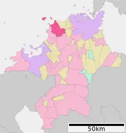
 Location of Munakata in Fukuoka Prefecture | |
 Munakata Location in Japan | |
| Coordinates: 33°48′N 130°32′E / 33.800°N 130.533°E | |
| Country | Japan |
| Region | Kyushu Region |
| Prefecture | Fukuoka Prefecture |
| first official recorded | 391 AD |
| City Settled | April 1, 1981 |
| Government | |
| • Mayor | Misako Izu (from May 2018) |
| Area | |
| • Total | 119.94 km2 (46.31 sq mi) |
| Population (April 30, 2022) | |
| • Total | 97,098 |
| • Density | 810/km2 (2,100/sq mi) |
| Time zone | UTC+09:00 (JST) |
| City hall address | 1-1-1 Tōgō, Munakata-shi, Fukuoka-ken 811-3492 |
| Climate | Cfa |
| Website | www |
| Symbols | |
| Flower | Japanese lily |
| Tree | Camphor laurel |
Munakata (宗像市, Munakata-shi) is a city in Japan, located in Fukuoka Prefecture, in the north Chikuzen region of the prefecture. The city was founded on April 1, 1981. As of April 30, 2022, the city has an estimated population of 97,098 and a population density of 810 persons per km2. The total area is 119.94 km2.
Efforts have been made to inculcate Japan-South Korea friendship, and also friendship with New Zealand in recent years.
History

_2.JPG.webp)
The origin of the name Munakata is said to be from "Minokatachi" or "Minokata" from the enshrinement of three Munakata goddesses, descended from sword of Susanoo-no-Mikoto and mentioned in the Kojiki.
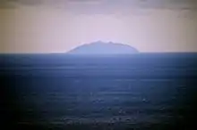
The area has prospered from trade with China and Korea from ancient times. It has been a World Heritage Site (Okinoshima) at Munakata Shrine. Munakata Shrine specifies itself as the territory of the god of Kyūshū during the Asuka period — ranging from Onga in the east, south to Wakamiya and Miyata, and Shingū in the west. During the age of civil wars a daimyō with leading Shinto priest and Munakata Ujisada of Munakata Shrine established Tsutagadake castle (Mount Jo). Through this, Munakata, Onga and Kurate were protected from invasion by other daimyos such as Tachibana Dōsetsu and the Ōtomo clan. There are also ghost stories connected with the area since the Yamada incident arose.
On April 1, 2003, City of Munakata and Genkai (from Munakata District) municipalities to become a new and expanded City.
On March 28, 2005, the village of Ōshima (also from Munakata District) was absorbed into Munakata city.
In the earthquake on March 20, 2005, damage was done in various parts of the city. The quake registered just under five on the Japan Meteorological Agency seismic intensity scale.
Geography
Mountain
- Mt. Joyama (Mt. Tsurugatake)
- Mt. Konomiyama
- Mt. Hakuzan
- Mt. Kodaishiyama
- Mt. Yugawayama
- Mt. Kanayama
- Mt. Shintateyama
Rivers
- Tsuri river
Climate
Munakata has a humid subtropical climate (Köppen: Cfa). The average annual temperature in Munakata is 15.9 °C (60.6 °F). The average annual rainfall is 1,665.2 mm (65.56 in) with July as the wettest month. The temperatures are highest on average in August, at around 27.0 °C (80.6 °F), and lowest in January, at around 5.8 °C (42.4 °F).[1] The highest temperature ever recorded in Munakata was 37.2 °C (99.0 °F) on 21 August 2010; the coldest temperature ever recorded was −9.2 °C (15.4 °F) on 19 February 1977.[2]
| Climate data for Munakata (1991−2020 normals, extremes 1977−present) | |||||||||||||
|---|---|---|---|---|---|---|---|---|---|---|---|---|---|
| Month | Jan | Feb | Mar | Apr | May | Jun | Jul | Aug | Sep | Oct | Nov | Dec | Year |
| Record high °C (°F) | 20.4 (68.7) |
23.5 (74.3) |
25.2 (77.4) |
30.4 (86.7) |
31.6 (88.9) |
33.7 (92.7) |
35.8 (96.4) |
37.2 (99.0) |
35.6 (96.1) |
32.4 (90.3) |
26.8 (80.2) |
24.8 (76.6) |
37.2 (99.0) |
| Mean daily maximum °C (°F) | 9.7 (49.5) |
10.7 (51.3) |
13.9 (57.0) |
18.8 (65.8) |
23.5 (74.3) |
26.4 (79.5) |
29.8 (85.6) |
31.0 (87.8) |
27.4 (81.3) |
22.7 (72.9) |
17.5 (63.5) |
12.1 (53.8) |
20.3 (68.5) |
| Daily mean °C (°F) | 5.8 (42.4) |
6.5 (43.7) |
9.4 (48.9) |
13.8 (56.8) |
18.4 (65.1) |
22.2 (72.0) |
26.2 (79.2) |
27.0 (80.6) |
23.3 (73.9) |
18.0 (64.4) |
12.7 (54.9) |
7.8 (46.0) |
15.9 (60.7) |
| Mean daily minimum °C (°F) | 1.7 (35.1) |
1.9 (35.4) |
4.4 (39.9) |
8.6 (47.5) |
13.4 (56.1) |
18.6 (65.5) |
23.1 (73.6) |
23.8 (74.8) |
19.7 (67.5) |
13.4 (56.1) |
7.9 (46.2) |
3.3 (37.9) |
11.7 (53.0) |
| Record low °C (°F) | −5.7 (21.7) |
−9.2 (15.4) |
−5.1 (22.8) |
−1.9 (28.6) |
2.8 (37.0) |
5.9 (42.6) |
14.4 (57.9) |
16.3 (61.3) |
6.7 (44.1) |
1.1 (34.0) |
−1.9 (28.6) |
−4.7 (23.5) |
−9.2 (15.4) |
| Average precipitation mm (inches) | 85.7 (3.37) |
76.3 (3.00) |
119.1 (4.69) |
134.4 (5.29) |
137.0 (5.39) |
230.2 (9.06) |
302.4 (11.91) |
177.1 (6.97) |
150.7 (5.93) |
84.9 (3.34) |
91.2 (3.59) |
76.2 (3.00) |
1,665.2 (65.56) |
| Average precipitation days (≥ 1.0 mm) | 10.5 | 9.9 | 10.9 | 10.3 | 8.9 | 11.9 | 11.1 | 9.3 | 9.9 | 7.4 | 8.9 | 9.2 | 118.2 |
| Mean monthly sunshine hours | 100.1 | 118.2 | 159.3 | 185.4 | 200.6 | 139.9 | 178.8 | 209.0 | 164.8 | 173.1 | 134.4 | 106.5 | 1,870.1 |
| Source: Japan Meteorological Agency[1][2] | |||||||||||||
Demographics
Per Japanese census data, the population of Munakata in 2020 is 97,095 people.[3] Munakata has been conducting censuses since 1950.
| Year | Pop. | ±% |
|---|---|---|
| 1950 | 34,217 | — |
| 1955 | 34,942 | +2.1% |
| 1960 | 33,537 | −4.0% |
| 1965 | 34,029 | +1.5% |
| 1970 | 40,309 | +18.5% |
| 1975 | 56,194 | +39.4% |
| 1980 | 66,985 | +19.2% |
| 1985 | 71,389 | +6.6% |
| 1990 | 78,197 | +9.5% |
| 1995 | 86,938 | +11.2% |
| 2000 | 92,056 | +5.9% |
| 2005 | 94,148 | +2.3% |
| 2010 | 95,481 | +1.4% |
| 2015 | 96,516 | +1.1% |
| 2020 | 97,095 | +0.6% |
| Munakata population statistics[3] | ||
Twin towns – sister cities
 Gimhae city(South Gyeongsang Province, South Korea)(1992, sister city concluded. At the time of conclusion, former Munakata City.)
 Seongsan-eup, Seogwipo city(Jeju Province, South Korea)(1991, Friendship and Exchange City concluded. At the time of conclusion, former Genkai Town. At the time of conclusion, it was seongsan-eup, Namjeju County)
 Kazanlak(Stara Zagora Province, Bulgaria)(2010, Friendship and Exchange City concluded.)
Tourism
Akama
Akama (赤間) is a historical district and city center of Munakata. Half of the people in Munakata live there. It contains rows of old houses belonging, along with the original Akama hotel and two now-ruined castles: Hakusan Castle and Tsutagadake Castle. The Shinto priest and founder of Munakata Shrine was a local military leader in medieval times. It is also connected to the period in history when Saigō Takamori and Takasugi Shinsaku were in conflict with the national government.
The main JR Kyūshū train station in Munakata is called Akama, and is a part of the Kagoshima Main Line. The city is also served by the Kyōikudaimae and Tōgō JR stations.
Sports facilities
- Global Arena, which has hosted the Sanix World Rugby Youth Invitational Tournament since 2000
- Genkai Ground, which hosts the Munakata Sanix Blues rugby team
References
- 1 2 気象庁 / 平年値(年・月ごとの値). JMA. Retrieved May 21, 2022.
- 1 2 観測史上1~10位の値(年間を通じての値). JMA. Retrieved May 21, 2022.
- 1 2 Munakata population statistics
External links
- Munakata City official website (in Japanese)