 | ||||
|---|---|---|---|---|
| 国道19号 | ||||
 | ||||
| Route information | ||||
| Length | 266.4 km[1] (165.5 mi) | |||
| Location | ||||
| Country | Japan | |||
| Highway system | ||||
| ||||
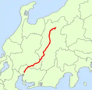
National Route 19 (国道19号, Kokudō jūkyū-gō) is a national highway connecting Nagoya and Nagano in Japan.[2]
Route data
- Length: 258.9 km (165.5 mi)
- Origin: Atsuta-ku, Nagoya, Nagoya (originates at junction with Route 1)
- Terminus: Nagano City (ends at Junction with Route 18)
- Major cities: Kasugai, Tajimi, Nakatsugawa, Shiojiri, Matsumoto, Azumino
History
- 4 December 1952 - Designation as First Class National Highway 19 (from Nagoya to Nagano, Nagano)
- 1 April 1965 - Designation as General National Highway 19 (from Nagoya to Nagano, Nagano)
Overlapping sections
- From Atsuta, Nagoya (Atsuta Shrine South intersection) to Naka, Nagoya (Nichigin-mae intersection): Route 22
- From Toki (Odomi intersection) to Mizunami (Yamanouchi intersection): Route 21
- From Ena (Shoke intersection) to Sendambayashi, Nakatsugawa: Route 257
- From Nakatsugawa (Iyasaka-bashi intersection) to Nagiso (Azuma-bashi intersection): Route 256
- In Kiso Town, from Kiso-ohashi intersection to Hiyoshi-Ozawabara intersection: Route 361
Municipalities passed through
Intersects with
Bypasses
- Kasugai Bypass
- Utsutsu Bypass
- Tajimi Bypass
- Toki Bypass
- Mizunami Bypass
- Ena Bypass
- Nakatsugawa Bypass
- Agematsu Bypass
- Matsumoto Bypass
- Naganominami Bypass
References
- ↑ "一般国道の路線別、都道府県別道路現況" [Road statistics by General National Highway route and prefecture] (PDF) (in Japanese). Ministry of Land, Infrastructure, Transport and Tourism. Retrieved 19 February 2020.
- ↑ 一般国道19号 (in Japanese). Ministry of Land, Infrastructure, Transport and Tourism. Kanto Regional Development Bureau. Archived from the original on 28 September 2011. Retrieved 29 November 2010.
Wikimedia Commons has media related to Route 19 (Japan).
This article is issued from Wikipedia. The text is licensed under Creative Commons - Attribution - Sharealike. Additional terms may apply for the media files.