 | ||||
|---|---|---|---|---|
| 国道394号 | ||||
Japan National Route 394 highlighted in red | ||||
 | ||||
| Route information | ||||
| Length | 185.0 km[1] (115.0 mi) | |||
| Existed | 1 April 1982–present | |||
| Major junctions | ||||
| North end | ||||
| South end | ||||
| Location | ||||
| Country | Japan | |||
| Highway system | ||||
| ||||
National Route 394 (国道394号, Kokudō San hyaku kyū jūyongō) is a national highway in the Japanese prefecture of Aomori. Route 394 stretches 185 km (115 miles) from National Routes 279 and 338 in Mutsu southwest to National Route 7 in Hirosaki.
Route description
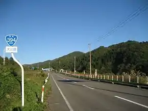
The route has a total length of 185 km (114.95 mi). It travels southwest across Aomori Prefecture connecting the cities of Mutsu and Hirosaki by traveling over the Hakkōda Mountains in the center of the prefecture.
History
National Route 394 was designated as route connecting Mutsu to Aomori in 1982;[2] however, many of the sections of roadway that make up the highway predate this designation, including a bridge along the highway over Lake Ogawara that was built in 1958.[3] Its routing has changed since its designation. In Shichinohe, the road used to parallel National Route 4 and National Route 45 for a short distance until March 2015. In the same town on 27 November 2018, the route was moved slightly to the west to better facilitate the junction between it and the Kamikita Expressway.[4]
Future
Improvements on the highway near the interchange with the Kamikita Expressway continue. A project to straighten a 1.9-kilometer-long (1.2 mi) section of the road north of the junction is planned by the government of Aomori Prefecture.[5]
Major junctions and features
The route lies entirely within Aomori Prefecture. Distance markers reflect distance traveled from the junction with National Route 338 in Rokkasho.
| Location | km | mi | Destinations | Notes | |||
|---|---|---|---|---|---|---|---|
| Mutsu | Northern terminus; northern end of unsigned National Route 338 concurrency | ||||||
| See National Route 338 | |||||||
| Rokkasho | 0 | 0.0 | Southern end of unsigned National Route 338 concurrency; beginning of distance markers | ||||
| Shichinohe | 24.5 | 15.2 | Current western terminus of the Kamikita Expressway | ||||
| 29.7 | 18.5 | National Route 45 is unsigned | |||||
| Aomori | 54.0 | 33.6 | Aomori Prefecture Route 40 (Aomori-Tashiro-Towada route) | ||||
| Towada | 60.4 | 37.5 | Northern end of National Route 103 concurrency | ||||
| Aomori | 70.8 | 44.0 | Southern end of National Route 103 concurrency | ||||
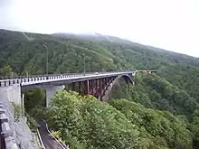
| 71.4– 71.8 | 44.4– 44.6 | Jōgakura Bridge | |||||
| Kuroishi | 87.9 | 54.6 | Northern end of National Route 102 concurrency (National Route 394 is unsigned) | ||||
| 94.2 | 58.5 | Interchange; Tōhoku Expressway exit 52 | |||||
| Hirosaki | 103.5 | 64.3 | Interchange; southern end of National Route 102 concurrency; southern terminus | ||||
1.000 mi = 1.609 km; 1.000 km = 0.621 mi
| |||||||
References
- ↑ "一般国道の路線別、都道府県別道路現況" [Road statistics by General National Highway route and prefecture] (PDF) (in Japanese). Ministry of Land, Infrastructure, Transport and Tourism. Retrieved 18 February 2020.
- ↑ "一般国道の路線を指定する政令" (in Japanese). Retrieved 25 June 2019.
- ↑ "橋梁点検結果一覧表" [Bridge inspection result list] (PDF) (in Japanese). Aomori Prefecture. 7 December 2016. Retrieved 16 April 2021.
- ↑ "榎林BP(七戸)27日、駒沢BP(三沢)30日開通" [Tenmabashi Bypass (Shichinohe) opened on 27th, Komazawa Bypass (Misawa) opened on the 30th]. The Tō-Ō Nippō Press (in Japanese). 9 November 2018. Retrieved 12 December 2018.
- ↑ "国道394号【榎林しバイパス】開通のお知らせ" [Opening of the National Route 394 (Enokibayashi Bypass)] (PDF) (in Japanese). Aomori Prefecture Government. 9 November 2018. Retrieved 18 December 2020.