La Chapelle-d'Alagnon | |
|---|---|
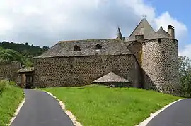 The Château of Jarrousset | |
Location of La Chapelle-d'Alagnon | |
 La Chapelle-d'Alagnon  La Chapelle-d'Alagnon | |
| Coordinates: 45°06′30″N 2°53′50″E / 45.1083°N 2.8972°E | |
| Country | France |
| Region | Auvergne-Rhône-Alpes |
| Department | Cantal |
| Arrondissement | Saint-Flour |
| Canton | Murat |
| Intercommunality | Hautes Terres |
| Government | |
| • Mayor (2020–2026) | Gérard Pouderoux[1] |
| Area 1 | 9.2 km2 (3.6 sq mi) |
| Population | 259 |
| • Density | 28/km2 (73/sq mi) |
| Time zone | UTC+01:00 (CET) |
| • Summer (DST) | UTC+02:00 (CEST) |
| INSEE/Postal code | 15041 /15300 |
| Elevation | 860–1,124 m (2,822–3,688 ft) (avg. 882 m or 2,894 ft) |
| 1 French Land Register data, which excludes lakes, ponds, glaciers > 1 km2 (0.386 sq mi or 247 acres) and river estuaries. | |
La Chapelle-d'Alagnon (French pronunciation: [la ʃapɛl dalaɲɔ̃]; Occitan: La Chapèla d'Alanhon) is a commune in the Cantal department in south-central France.
Population
| Year | Pop. | ±% |
|---|---|---|
| 1962 | 256 | — |
| 1968 | 264 | +3.1% |
| 1975 | 239 | −9.5% |
| 1982 | 246 | +2.9% |
| 1990 | 236 | −4.1% |
| 1999 | 250 | +5.9% |
| 2008 | 240 | −4.0% |
See also
References
- ↑ "Répertoire national des élus: les maires" (in French). data.gouv.fr, Plateforme ouverte des données publiques françaises. 13 September 2022.
- ↑ "Populations légales 2021". The National Institute of Statistics and Economic Studies. 28 December 2023.
Wikimedia Commons has media related to La Chapelle-d'Alagnon.
This article is issued from Wikipedia. The text is licensed under Creative Commons - Attribution - Sharealike. Additional terms may apply for the media files.