Saint-Georges | |
|---|---|
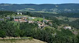 A general view of Saint-Georges | |
Location of Saint-Georges | |
 Saint-Georges  Saint-Georges | |
| Coordinates: 45°01′10″N 3°07′42″E / 45.0194°N 3.1283°E | |
| Country | France |
| Region | Auvergne-Rhône-Alpes |
| Department | Cantal |
| Arrondissement | Saint-Flour |
| Canton | Neuvéglise-sur-Truyère |
| Government | |
| • Mayor (2020–2026) | Jean-Jacques Monloubou[1] |
| Area 1 | 33.14 km2 (12.80 sq mi) |
| Population | 1,183 |
| • Density | 36/km2 (92/sq mi) |
| Time zone | UTC+01:00 (CET) |
| • Summer (DST) | UTC+02:00 (CEST) |
| INSEE/Postal code | 15188 /15100 |
| Elevation | 740–1,001 m (2,428–3,284 ft) (avg. 828 m or 2,717 ft) |
| 1 French Land Register data, which excludes lakes, ponds, glaciers > 1 km2 (0.386 sq mi or 247 acres) and river estuaries. | |
Saint-Georges (French pronunciation: [sɛ̃ ʒɔʁʒ] ⓘ; Auvergnat: Sant Georges) is a commune in the Cantal department in south-central France.
Population
| Year | Pop. | ±% |
|---|---|---|
| 1962 | 762 | — |
| 1968 | 774 | +1.6% |
| 1975 | 893 | +15.4% |
| 1982 | 1,036 | +16.0% |
| 1990 | 1,039 | +0.3% |
| 1999 | 939 | −9.6% |
| 2008 | 1,148 | +22.3% |
| 2016 | 1,178 | +2.6% |
See also
References
- ↑ "Répertoire national des élus: les maires". data.gouv.fr, Plateforme ouverte des données publiques françaises (in French). 2 December 2020.
- ↑ "Populations légales 2021". The National Institute of Statistics and Economic Studies. 28 December 2023.
Wikimedia Commons has media related to Saint-Georges (Cantal).
This article is issued from Wikipedia. The text is licensed under Creative Commons - Attribution - Sharealike. Additional terms may apply for the media files.