Murat | |
|---|---|
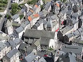
 The church and surrounding buildings, in Murat | |
.svg.png.webp) Coat of arms | |
Location of Murat | |
 Murat  Murat | |
| Coordinates: 45°06′38″N 2°52′10″E / 45.1106°N 2.8694°E | |
| Country | France |
| Region | Auvergne-Rhône-Alpes |
| Department | Cantal |
| Arrondissement | Saint-Flour |
| Canton | Murat |
| Intercommunality | Hautes Terres Communauté |
| Government | |
| • Mayor (2020–2026) | Gilles Chabrier[1] |
| Area 1 | 20.26 km2 (7.82 sq mi) |
| Population | 1,792 |
| • Density | 88/km2 (230/sq mi) |
| Time zone | UTC+01:00 (CET) |
| • Summer (DST) | UTC+02:00 (CEST) |
| INSEE/Postal code | 15138 /15300 |
| Elevation | 868–1,163 m (2,848–3,816 ft) |
| 1 French Land Register data, which excludes lakes, ponds, glaciers > 1 km2 (0.386 sq mi or 247 acres) and river estuaries. | |
Murat (French pronunciation: [myʁa]) is a commune in the Cantal department in the Auvergne region in south-central France. On 1 January 2017, the former commune of Chastel-sur-Murat was merged into Murat.[3] Murat is the administrative seat of this new commune.
History

On 24 June 1944, during World War II, 120 Muratais were deported, 80 never returned.
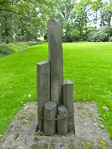
The French people from Murat were deported via Compiègne to the Neuengamme concentration camp and most of them had to work in the subcamp (in German: Außenlager) Farge concentration camp. At begin of June, 2012 a monument in the Memorial wood on the gardening area of former concentration camp was established: It was donated by the city of Murat, to remember what happened in Murat and to commemorate the deported and murdered inhabitants.[4][5][6] The columns of basalt remember July 1944 when the Maquisards from Murat, Cantal were deported and afterwards murdered in the Neuengamme concentration camp and its affiliates. In total 75 men out of 103 died in the concentration camp.[7]
Geography
Location
Murat is situated on the eastern edge of the Mounts of Cantal, in the valley of the Alagnon, a tributary of the Allier, which was the principal route for crossing the Massif Central. It is surrounded by three basalt outcrops, the vestiges of former volcanoes, the Rocher de Bredons, where there is a priory church dating from the 12th century, the rocher de Bonnevie, where there is an 8-metre high statue of the Virgin Mary known as Notre-Dame de la Haute-Auvergne, and the Rocher de Chastel, where the 12th century chapel of St Antoine stands. A market is held every Friday.
Population
| Year | Pop. | ±% p.a. |
|---|---|---|
| 1968 | 2,741 | — |
| 1975 | 2,731 | −0.05% |
| 1982 | 2,541 | −1.02% |
| 1990 | 2,509 | −0.16% |
| 1999 | 2,249 | −1.21% |
| 2009 | 2,161 | −0.40% |
| 2014 | 1,999 | −1.55% |
| 2020 | 1,815 | −1.60% |
| Source: INSEE[8] | ||
Population data refer to the commune in its geography as of January 2023.
Administration
Mayor (maire in French) of the municipal council:
| Name | Start | End | Notes |
|---|---|---|---|
| Martine Mahtouk | 2001 | 2008 | |
| Emmanuel Grèze | 1983 | 2001 | Former General councillor(Conseiller général[9]); Conseiller Régional |
| Jean Meyniel | 1977 | 1983 | |
| Antoine Tabayse | 1969 | 1977 | |
| Joseph Constant | 1968 | 1969 | |
| Hector Peschaud | 1946 | 1968 | |
| Antoine Combes | 1944 | 1946 | |
| Hector Peschaud | 1928 | 1944 | |
| Gabriel Peschaud | 1897 | 1928 | Député |
| Raymond Teissèdre | 1896 | 1897 | |
| Leon Auguste Teillard Chabrier | 1895 | 1896 | |
| Maurice guibal[10] | 1881 | 1895 | républicain General councillor (conseiller général) |
| Pierre Hector Veisseyre | 12 February 1878 | ||
| Joseph Léon Dubois | 3 November 1874 | ||
| Félix Robert | 13 February 1874 | ||
| Pierre Hector Veisseyre | 19 June 1871 | ||
| Alfred Talandier Espinasse | 29 September 1856 | ||
| Identité=Emile Teissèdre | 24 July 1852 | ||
| Jean Baptiste Rhodes | 11 November 1848 | ||
| Pierre Duclos | 2 May 1848 | ||
| Jules Teillard Laterisse | 29 December 1843 | ||
| François Escaille | 10 July 1833 | ||
| Antoine Talandier Lespinasse | 11 October 1830 | ||
| Jean baptiste Marcombes | 30 December 1825 | ||
| Identité=Pierre Maynobe | 16 June 1819 | ||
| Jean Raymond Rancillac de Chazelles | 11 November 1815 | ||
| Antoine Gazard | 5 July 1815 | ||
| Claude Amable Tournier | 5 June 1815 | ||
| Antoine Gazard | messidor an X | ||
| Cérice Bonaventure Teillard Chambon | 1st prairial an VII | ||
| Municipalités de canton | From An IV to An VIII | ||
| Joseph Dubois | 11 brumaire an III | ||
| François Teillard Beynac | 2 December 1792 | ||
| Cérice Bonaventure Teillard Chambon | 28 October 1792 | ||
| Antoine Dominique Chabanon | 15 May 1791 | ||
| Antoine Roux | 15 July 1790 | ||
| Etienne de Montreuil de Charmanière | 9 February 1790 | ||
Personalities
- Olivier Magne
- Raymond Leopold Bruckberger,[12] writer
- Henri de Castellane, politician. His grandson was Paul Ernest Boniface de Castellane who married Anna Gould
See also
References
- ↑ "Répertoire national des élus: les maires". data.gouv.fr, Plateforme ouverte des données publiques françaises (in French). 2 December 2020.
- ↑ "Populations légales 2021". The National Institute of Statistics and Economic Studies. 28 December 2023.
- ↑ Arrêté préfectoral 16 December 2016 (in French)
- ↑ (fr) Murat, Cantal at the Internet Archive
- ↑ Klaus Witzeling: Bekannte Orte, historisch gesehen (title translated to English: Well known places in historical view). In: Hamburger Abendblatt, from May 29, 2012, Beilage Museumswelt Hamburg, Frühjahr 2012, p. 16.
- ↑ Senatorin weiht Mahnmal für Deportierte aus Murat ein (title translated to English: Senator inaugurates the monument for the deported people from Murat). In: Bergedorfer Zeitung, from June 7, 2012.
- ↑ Unrest in Murat
- ↑ Population en historique depuis 1968, INSEE
- ↑ General councils of France
- ↑ ended the building of The Villa or Castel Marguerite in Neussargues-Moissac.
- ↑ Some information is quoted from the article of Mr. Philippart: (in French) Murat à la fin du XIXe siècle: une cité, un maire, un journal.
- ↑ (in French) Raymond Leopol Bruckberger Notice biographique de l'Académie des sciences morales et politiques Archived 2007-04-08 at the Wayback Machine
External links
- (in English) Volcano park of Auvergne on the UNEP-WCMC site
- (in French) Albepierre-Bredons