Saint-Clément | |
|---|---|
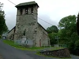 The Church of Saint-Clément | |
Location of Saint-Clément | |
 Saint-Clément  Saint-Clément | |
| Coordinates: 44°58′32″N 2°39′42″E / 44.9756°N 2.6617°E | |
| Country | France |
| Region | Auvergne-Rhône-Alpes |
| Department | Cantal |
| Arrondissement | Aurillac |
| Canton | Vic-sur-Cère |
| Intercommunality | Cère et Goul en Carladès |
| Government | |
| • Mayor (2020–2026) | Jean-Baptiste Amilhaud[1] |
| Area 1 | 17.43 km2 (6.73 sq mi) |
| Population | 77 |
| • Density | 4.4/km2 (11/sq mi) |
| Time zone | UTC+01:00 (CET) |
| • Summer (DST) | UTC+02:00 (CEST) |
| INSEE/Postal code | 15180 /15800 |
| Elevation | 788–1,554 m (2,585–5,098 ft) (avg. 1,000 m or 3,300 ft) |
| 1 French Land Register data, which excludes lakes, ponds, glaciers > 1 km2 (0.386 sq mi or 247 acres) and river estuaries. | |
Saint-Clément (French pronunciation: [sɛ̃ klemɑ̃]; Auvergnat: Sant Clamenç) is a commune in the Cantal department in south-central France.
Population
| Year | Pop. | ±% |
|---|---|---|
| 1962 | 150 | — |
| 1968 | 185 | +23.3% |
| 1975 | 172 | −7.0% |
| 1982 | 136 | −20.9% |
| 1990 | 107 | −21.3% |
| 1999 | 80 | −25.2% |
| 2008 | 70 | −12.5% |
| 2016 | 75 | +7.1% |
See also
References
- ↑ "Répertoire national des élus: les maires". data.gouv.fr, Plateforme ouverte des données publiques françaises (in French). 9 August 2021.
- ↑ "Populations légales 2021". The National Institute of Statistics and Economic Studies. 28 December 2023.
Wikimedia Commons has media related to Saint-Clément (Cantal).
This article is issued from Wikipedia. The text is licensed under Creative Commons - Attribution - Sharealike. Additional terms may apply for the media files.