La Lande-Saint-Léger | |
|---|---|
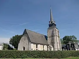 The church of Saint-Léger | |
.svg.png.webp) Coat of arms | |
Location of La Lande-Saint-Léger | |
 La Lande-Saint-Léger  La Lande-Saint-Léger | |
| Coordinates: 49°18′01″N 0°21′55″E / 49.3003°N 0.3653°E | |
| Country | France |
| Region | Normandy |
| Department | Eure |
| Arrondissement | Bernay |
| Canton | Beuzeville |
| Intercommunality | Lieuvin Pays d'Auge |
| Government | |
| • Mayor (2020–2026) | Manuel Mordant[1] |
| Area 1 | 7.96 km2 (3.07 sq mi) |
| Population | 396 |
| • Density | 50/km2 (130/sq mi) |
| Time zone | UTC+01:00 (CET) |
| • Summer (DST) | UTC+02:00 (CEST) |
| INSEE/Postal code | 27361 /27210 |
| Elevation | 38–152 m (125–499 ft) (avg. 152 m or 499 ft) |
| 1 French Land Register data, which excludes lakes, ponds, glaciers > 1 km2 (0.386 sq mi or 247 acres) and river estuaries. | |
La Lande-Saint-Léger (French pronunciation: [la lɑ̃d sɛ̃ leʒe]) is a commune in the Eure department in Normandy in northern France.
Population
| Year | Pop. | ±% |
|---|---|---|
| 1962 | 220 | — |
| 1968 | 222 | +0.9% |
| 1975 | 198 | −10.8% |
| 1982 | 164 | −17.2% |
| 1990 | 201 | +22.6% |
| 1999 | 208 | +3.5% |
| 2008 | 289 | +38.9% |
See also
References
- ↑ "Répertoire national des élus: les maires" (in French). data.gouv.fr, Plateforme ouverte des données publiques françaises. 13 September 2022.
- ↑ "Populations légales 2021". The National Institute of Statistics and Economic Studies. 28 December 2023.
Wikimedia Commons has media related to La Lande-Saint-Léger.
This article is issued from Wikipedia. The text is licensed under Creative Commons - Attribution - Sharealike. Additional terms may apply for the media files.