Popovice | |
|---|---|
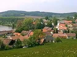
 General view | |
 Flag  Coat of arms | |
 Popovice Location in the Czech Republic | |
| Coordinates: 49°41′44″N 14°45′9″E / 49.69556°N 14.75250°E | |
| Country | |
| Region | Central Bohemian |
| District | Benešov |
| First mentioned | 1295 |
| Area | |
| • Total | 11.72 km2 (4.53 sq mi) |
| Elevation | 435 m (1,427 ft) |
| Population (2023-01-01)[1] | |
| • Total | 284 |
| • Density | 24/km2 (63/sq mi) |
| Time zone | UTC+1 (CET) |
| • Summer (DST) | UTC+2 (CEST) |
| Postal codes | 257 01, 257 03 |
| Website | www |
Popovice is a municipality and village in Benešov District in the Central Bohemian Region of the Czech Republic. It has about 300 inhabitants.
Administrative parts
Villages and hamlets of Kamenná Lhota, Kondratice, Mladovice, Pazderná Lhota and Věžníčky are administrative parts of Popovice.
Geography
Popovice is located about 11 kilometres (7 mi) southeast of Benešov and 41 km (25 mi) southeast of Prague. It lies in the Vlašim Uplands. The highest point is the hill Červíková skála at 578 m (1,896 ft) above sea level. The Chotýšanka River flows through the municipality. The village of Popovice lies on the shore of Popovický Pond.
History
The first written mention of Popovice is from 1295.[2]
Sights
The main landmark is the Church of Saint James the Great. It was built in the late Romanesque style and later rebuilt.[3]
Popovice Fortress is a former fortress, rebuilt into a castle. This Baroque building also contains preserved Gothic and Renaissance elements, and the torso of medieval walls.[4]
References
- ↑ "Population of Municipalities – 1 January 2023". Czech Statistical Office. 2023-05-23.
- ↑ "Obec Popovice" (in Czech). Mikroregion CHOPOS. Retrieved 2023-04-14.
- ↑ "Kostel sv. Jakuba" (in Czech). National Heritage Institute. Retrieved 2023-04-14.
- ↑ "Tvrz" (in Czech). National Heritage Institute. Retrieved 2023-04-14.